By Staff Writer
Published: 10 January 2026 [updated 11 January]
This forecast is for: Sun 11 January 2026
The maps cover: Sun 11 Jan – Sun 11 Jan
The latest forecast is available by clicking here.
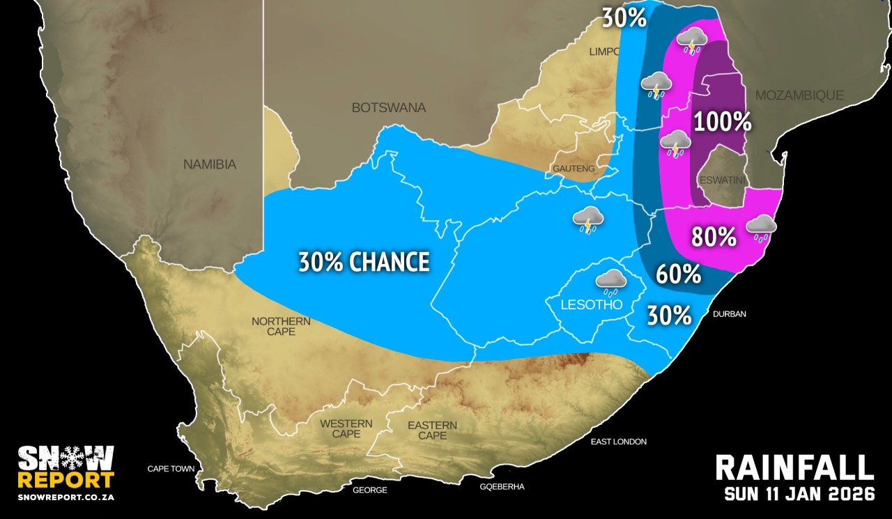
Widespread showers and thundershowers are expected over the north-eastern parts of South Africa on Sunday. Models are indicating significant amounts of rain in excess of 100mm for some areas and significant impacts are possible over these areas. Morning and/or evening fog can be expected in a number of areas.
Very hot to extremely hot and uncomfortable conditions are expected over most places in the Western and Northern Cape, except the south coast of the Western Cape and Richtersveld municipality of the Northern Cape on Sunday. Daytime temperatures are expected to reach the mid to high 30s or low 40s.
According to the SA Weather Service (SAWS), the low-pressure system currently located over the southern parts of Mozambique is expected to significantly influence weather conditions over north-eastern South Africa over the coming days.
SAWS said current weather forecasts indicate that the Lowveld of Mpumalanga, the Limpopo Valley, and most eastern parts of Limpopo are likely to experience widespread and persistent rain and thunderstorms until at least Wednesday and possibly beyond.
For these regions, significant rainfall accumulations are expected throughout the week, beginning from Sunday evening.
Warnings from the SA Weather Service for Sunday:
A. level 6 warning for severe thunderstorms resulting in continuous heavy downpours leading to flooding of susceptible roads, damage or loss of infrastructure, settlements (formal and informal), danger to life (fast flowing streams/deep water), disruption of municipal and other essential services in the Lowveld and escarpment areas of both Mpumalanga and Limpopo.
B. level 5 warning for severe thunderstorms resulting in continuous heavy downpours leading to flooding of susceptible roads, damage or loss of infrastructure, settlements (formal and informal), danger to life (fast flowing streams/deep water), disruption of municipal and other essential services in the extreme north-east of KwaZulu-Natal on Sunday.
C. level 2 warning for severe thunderstorms resulting in heavy downpours leading to localised flooding of susceptible roads, settlements, low-lying bridges/areas, strong damaging winds, hail and excessive lightning over the eastern Highveld of both Mpumalanga and Limpopo, as well as parts of KwaZulu-Natal.
Extremely high fire danger conditions are expected over the southern parts of Sarah Baartman District and Nelson Mandela Municipality of the Eastern Cape, the vast parts of the Northern Cape, the northern and central parts of the Western Cape.
Regional forecasts from the SA Weather Service for Sunday:
GAUTENG
Partly cloudy in the morning, otherwise cloudy and warm but hot in the extreme north.
MPUMALANGA
Morning fog patches along the escarpment areas, otherwise cloudy and cool to warm with scattered to widespread showers and thundershowers, but isolated in the extreme west.
LIMPOPO
Morning fog patched over the south-eastern parts, otherwise cloudy and cool to warm with isolated to scattered showers and thundershowers over the central and eastern parts, otherwise widespread over the Lowveld and escarpment areas.
NORTH-WEST
Fine at first, otherwise partly cloudy and warm to hot, with isolated afternoon showers and thundershowers in the east.
THE FREE STATE
Morning fog in the east where with isolated afternoon showers and thundershowers are expected, otherwise partly cloudy and warm to hot.
THE NORTHERN CAPE
Fog patches along the coast in the morning and evening, otherwise fine and hot to very hot, but partly cloudy in the east and central by afternoon. The wind along the coast will be light and variable.
THE WESTERN CAPE
Partly cloudy along the south coast, otherwise fine and warm to hot but very extremely hot in places. The wind along the coast will be light to moderate westerly to north-westerly along the north-west coast otherwise southerly to south-easterly but fresh to strong along the south-west.
THE WESTERN HALF OF THE EASTERN CAPE
Morning fog patches in places in the southern interior as well as along the along the coast in the evening, otherwise fine and warm but hot to very hot over the interior. The wind along the coast will be moderate to fresh easterly.
THE EASTERN HALF OF THE EASTERN CAPE
Morning fog patches in places in the southern interior as well as along the coast and adjacent interior in the evening, otherwise fine and warm but hot to very hot over the interior. It will become partly cloudy in the afternoon with isolated afternoon thunderstorms over the north-eastern escarpment. The wind along the coast will be moderate to fresh north-easterly.
KWAZULU-NATAL
Morning fog over the interior, otherwise cloudy and warm with isolated to scattered showers and thundershowers but widespread in the north. The wind along the coast will be moderate easterly to south-easterly north of Mtunzini in the morning, otherwise moderate to fresh northerly to north-easterly.
Travellers forecasts from the SA Weather Service for Sunday:
PRETORIA
Partly cloudy.
Minimum/Maximum: 17/31°C
JOHANNESBURG
Partly cloudy.
Minimum/Maximum: 14/27°C
VEREENIGING
Partly cloudy in the morning, otherwise cloudy.
Minimum/Maximum: 15/27°C
MBOMBELA
Cloudy with widespread showers and thundershower.
Minimum/Maximum: 18/23°C
POLOKWANE
Cloudy with scattered showers and thundershowers and showers.
Minimum/Maximum: 17/27°C
MAHIKENG
Fine, becoming partly cloudy in the afternoon.
Minimum/Maximum: 18/32°C
VRYBURG
Fine, becoming partly cloudy in the afternoon.
Minimum/Maximum: 18/32°C
BLOEMFONTEIN
Fine, becoming partly cloudy in the afternoon.
Minimum/Maximum: 17/33°C
KIMBERLEY
Fine, becoming partly cloudy in the afternoon.
Minimum/Maximum: 19/34°C
UPINGTON
Fine, becoming partly cloudy in the afternoon.
Minimum/Maximum: 23/39°C
CAPE TOWN
Fine, becoming partly cloudy from the evening.
Wind: Light to moderate southerly to south-easterly.
Minimum/Maximum: 19/33°C
GEORGE
Partly cloudy.
Wind: Light to moderate south-easterly.
Minimum/Maximum: 17/29°C
GQEBERHA
Fine, becoming cloudy in the evening with fog.
Wind: Moderate to fresh easterly.
Minimum/Maximum: 18/30°C
EAST LONDON
Fine, becoming cloudy in the evening with fog.
Wind: Moderate to fresh north easterly.
Minimum/Maximum: 19/27°C
DURBAN
Partly cloudy to cloudy with isolated showers and thundershowers.
Wind: Light to moderate northerly to north-easterly.
Minimum/Maximum: 20/28°C
RICHARDS BAY
Cloudy with widespread showers and thundershowers.
Wind: Moderate south-easterly, becoming light to moderate northerly to north-easterly from mid-morning.
Minimum/Maximum: 22/29°C
PIETERMARITZBURG
Morning fog, otherwise cloudy with isolated showers and thundershowers.
Minimum/Maximum: 16/28°C
This forecast is usually updated a few times per day.

Please be sure to send photos and videos to us via whatsapp and also tell us where and when they were taken.
Follow our channels