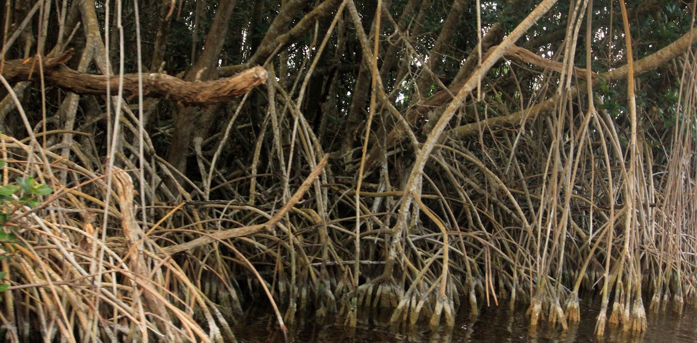
Rivers State on Nigeria’s coastline has some of Africa’s largest mangrove ecosystems. The Niger Delta itself contains the third-largest mangrove forest in the world. These trees support fisheries, biodiversity and the livelihoods of thousands of people.
The Niger Delta region is also the heart of the country’s oil and gas industry. Decades of oil exploration and production have altered its landscape. Pipeline construction, dredging (when sand is dug out of the ground), oil spills and gas flaring (burning) have degraded mangrove habitats. In addition, local communities use mangrove wood for fuel, construction and income generation.
The resulting damage to the environment – including mangrove forests – has weakened the natural coastal defences that once protected communities from flooding, erosion and storms.
Mangroves grow in shallow water. They act as biophysical barriers that dissipate wave energy, trap sediments and reduce the intensity of storm surges.
I am an environmental scientist working in coastal zone management, flood risk assessment and nature-based solutions for climate adaptation. My research focuses on how ecosystems help reduce coastal flood risk. In particular, I have looked at how natural ecosystems, particularly mangroves, contribute to coastal resilience and community protection in vulnerable coastal regions.
In my research I used ecosystem modelling tools to evaluate how changes in habitat condition influence exposure to flooding and erosion in coastal communities. The model scored and compared areas of healthy, continuous mangrove cover with areas where mangroves were degraded or cleared.
It showed that mangrove ecosystems provide a significant natural defence against flooding in the coastal communities of Rivers State. Areas with good mangrove cover scored lower for vulnerability.
This comparison confirms what local residents have long observed: that the loss of mangrove forests has led to more frequent and severe flooding events.
The study underscores the urgency of integrating nature-based solutions into local and national flood management policies.
Mangroves provide significant cover
The Niger Delta has recorded varying amounts of oil spill incidents since the 1970s. These have affected land, water and mangrove forests.
My study applied the InVEST Coastal Vulnerability model developed by the Natural Capital Project. The model uses information about a range of variables to generate exposure scores for places along the shoreline. The variables include shoreline type, wind and wave exposure, and the distribution of populations and infrastructure along the coast.
The score shows how vulnerable a place is to flooding. This allows direct comparisons between areas with intact mangroves and those that have lost mangroves.
A key insight from the modelling exercise was that the relationship between mangrove extent and flood protection is not simple. Narrow, fragmented mangrove belts offer limited protection. Wider and denser belts of mangroves have a disproportionately powerful effect. They substantially reduce wave energy and flood inundation.
This finding aligns with similar studies from south-east Asia and the Caribbean. These report that wider mangrove zones provide exponentially greater flood mitigation benefits.
The study further highlights the socio-ecological implications of mangrove degradation. The decline of mangrove cover driven by fuelwood harvesting, land conversion, oil infrastructure and pollution has eroded biodiversity and fisheries productivity. It has also reduced the resilience of human communities.
In places where mangroves have been lost, residents rely on infrastructure like sandbags or embankments. But these provide limited and temporary relief. Communities are becoming dependent on costly engineering measures rather than sustainable, ecosystem-based solutions.
What needs to be done
Restoring and protecting mangroves is a cost-effective way of reducing disaster risk. Natural coastal buffers reduce exposure to flooding and erosion. They also support livelihoods through fisheries, fuelwood and ecotourism. Mangroves also store carbon.
All these functions make them a cornerstone of climate adaptation in environments like the Niger Delta.
Urgent action is required to protect and restore mangrove ecosystems.
Rivers State could be a model for other coastal regions facing similar challenges. The model produces scenarios of “with mangroves” and “without mangroves”. This enables:
consequences of the presence or absence of mangroves to be seen
the production of maps. These can show areas where mangroves provide the most – and the least – support. So in real time, it shows areas where reforestation or afforestation efforts can be focused on.
These can be replicated in other coastal areas.
Mangrove conservation must be part of formal coastal zone management and spatial planning policies. This means recognising what mangroves can contribute to disaster risk reduction, urban development and climate adaptation strategies at state and national levels.
Large-scale mangrove restoration programmes must begin in degraded areas, especially those that have already experienced severe flooding. Restoration efforts should focus on reestablishing wide belts of trees with dense coverage, using native species and community-led approaches that ensure local participation and ownership.
Government and oil companies operating in the Niger Delta must do more to stop pollution, dredging and land-use practices that destroy mangroves. Aquaculture, eco-tourism and mangrove-friendly fisheries should be promoted to reduce dependence on unsustainable wood harvesting.
Capacity building and public awareness campaigns are essential to empower communities to manage mangrove ecosystems sustainably. By combining local knowledge with scientific evidence, policymakers, researchers and communities can develop effective, nature-based solutions that reduce flood risk while enhancing ecological and socio-economic resilience.