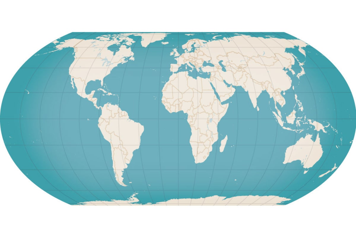
The African Union-backed Correct the Map campaign advocates the Equal Earth projection, shown here, as a fairer alternative to the Mercator projection – the world’s standard map.Murat Yukselir/The Globe and Mail
When a Trump administration official presented a cringingly erroneous map of Africa at a global conference last month, the blunder gave fresh momentum to a campaign for an accurate world map that would finally show the African continent in its true dimensions.
Each of the African countries highlighted on the U.S. map was wrongly labelled, while some were misshapen or incorrectly located. The U.S. State Department apologized and said it took “full responsibility” for the “unfortunate error” – but for many people it was the latest example of the cartography of Western misperceptions.
“It just showed the complete and utter disregard for the continent,” said Moky Makura, the executive director of Africa No Filter, a group that pushes for fairer representation of the continent. “Nobody bothered to check and nobody noticed.”
A screen shows a U.S. government map of Africa with mislabeled countries during a State Department presentation at a global conference in Rio de Janeiro, Brazil, on July 26.Picture obtained by REUTERS/Reuters
For centuries, she noted, traditional world maps have grossly underestimated Africa’s size. But now she and other activists are leading a campaign – backed by the African Union – to adopt the carefully calibrated “Equal Earth” map, with continents shown in their true proportions.
The campaign could soon reach the United Nations. Togo’s government has pledged to take the map grievance to the UN General Assembly at its annual meeting next month.
The injustice can be traced back to a world map created by the Flemish geographer Gerardus Mercator in 1569 that helped colonial-era sailors navigate across the oceans. The Mercator projection soon became the standard, even for today’s maps, but it exaggerated some land masses. Canada and Greenland dominate the top left side, each seemingly as large as Africa, while Europe and Russia command the centre.
It’s an illusion – taught in classrooms and textbooks − that has subconsciously diminished the world’s perception of the African continent. In reality, Africa is three times bigger than Canada and 14 times bigger than Greenland – yet the maps conceal this.
The traditional Mercator map is “the world’s longest misinformation campaign,” Ms. Makura said. “People knew it was wrong and continued to use it.”
Maps are storytelling tools, and they always told a story that marginalized Africa’s role in the world, pushing it to the edges of the global imagination, Ms. Makura told The Globe and Mail.

Proportional justice
Created in 1569, the Mercator projection became the world’s standard map, distorting the relative size of Africa and much of the Global South. The African Union-backed Correct the Map campaign advocates the Equal Earth projection as a fairer alternative.
MERCATOR PROJECTION
Invented for maritime exploration, it exaggerates the size of countries closer to the North and South poles while under-representing the size of much of South America and Africa.
A visual comparison of selected regions
in the Mercator projection
Versus actual surface areas in millions
of square kilometres
EQUAL EARTH PROJECTION
Developed in 2018 by an international team of cartographers, it addresses the distortions found in the Mercator projection.
MURAT YÜKSELIR / THE GLOBE AND MAIL, SOURCE:
NATURAL EARTH; WORLDATLAS

Proportional justice
Created in 1569, the Mercator projection became the world’s standard map, distorting the relative size of Africa and much of the Global South. The African Union-backed Correct the Map campaign advocates the Equal Earth projection as a fairer alternative.
MERCATOR PROJECTION
Invented for maritime exploration, it exaggerates the size of countries closer to the North and South poles while under-representing the size of much of South America and Africa.
A visual comparison of selected regions
in the Mercator projection
Versus actual surface areas in millions
of square kilometres
EQUAL EARTH PROJECTION
Developed in 2018 by an international team of cartographers, it addresses the distortions found in the Mercator projection.
MURAT YÜKSELIR / THE GLOBE AND MAIL, SOURCE:
NATURAL EARTH; WORLDATLAS

Proportional justice
Created in 1569, the Mercator projection became the world’s standard map, distorting the relative size of Africa and much of the Global South. The African Union-backed Correct the Map campaign advocates the Equal Earth projection as a fairer alternative.
MERCATOR PROJECTION
Invented for maritime exploration, it exaggerates the size of countries closer to the North and South poles while under-representing the size of much of South America and Africa.
A visual comparison of selected regions in the Mercator projection
Versus actual surface areas in millions of square kilometres
EQUAL EARTH PROJECTION
Developed in 2018 by an international team of cartographers, it addresses the distortions found in the Mercator projection.
MURAT YÜKSELIR / THE GLOBE AND MAIL, SOURCE: NATURAL EARTH; WORLDATLAS
After extensive research, the campaigners opted for the Equal Earth map, which was created in 2018 to show every land mass in its true size. Then they launched the #CorrectTheMap campaign, led by the advocacy groups Africa No Filter and Speak Up Africa.
In videos on social media, the campaign puts a spotlight on the severe distortions in existing maps. “This isn’t just about size,” the narrator says. “It’s about power and perception. It’s about a false sense of superiority over the Global South, and this needs to change.”
Even if the UN adopts a resolution to endorse the Equal Earth map, however, it has no legal power to impose the map on others. So the campaign is relying on education and awareness to build support for more accurate images.
Two geography professors at the University of Tennessee, Jack Swab and Derek Alderman, have warned that the inaccurate Mercator-based maps can cause damage in the real world. When U.S. President Donald Trump said he wanted the United States to take control of Greenland, he repeatedly cited its “massive” size – an assessment that was “likely influenced by map distortion,” the scholars said.
Togo will ask United Nations member states to adopt a world map that more accurately reflects the true size of Africa and ditch the 16th-century Mercator projection, its foreign minister said.
Reuters
The Mercator projection tends to inflate the size of places such as Canada and Greenland that are closer to the North or South poles. “As the largest continent in the global south, Africa is a victim of this cartographic inequity,” the geography professors noted in an analysis published last year.
For colonial empires, cartography was always a powerful tool of control, the two scholars said. Europeans drafted maps with blank spaces across Africa to imply that these were empty places that anyone could grab. European leaders then gathered at the Berlin Conference in 1885 to draw new lines on the maps, partitioning and carving up Africa for colonial possessions.
The campaign for a fairer map was given a dramatic boost a year ago when the African Union endorsed the goal, putting it onto the global agenda for the first time. The AU designated Togo’s government to spearhead the effort at the United Nations, including at the General Assembly next month.
Opinion: The moment the postcolonial domination of Africa finally ended
The AU, announcing its decision, complained that the Mercator map has always diminished a continent that comprises 20 per cent of the world’s land mass, with a population now reaching 1.6 billion.
“Bringing about changes won’t be easy,” professors Swab and Alderman said in their analysis. Because there is no central authority to govern the production of maps, the campaign will need to mobilize support from educators, diplomats, textbook publishers, the media and others.
Nor will a new map guarantee a fairer and more equal world. “But it’s a step towards restoring Africa’s rightful visibility on the world stage,” the scholars said.
The advocacy groups were enthused by the AU’s decision to campaign against the Mercator map. “This is not a small cartographic error,” Africa No Filter said in its social media posts. “This is centuries of distortion that has shaped how the world sees Africa − shrinking its significance, undermining its identity and diminishing its people.”
There is no guarantee that the UN will vote for the Equal Earth map next month. But the campaigners are optimistic.
“Why are we even having to ask?” Ms. Makura asked. “It’s a no-brainer.”