
Fifty-nine cities in Britain (83%) are highly vulnerable to urban heat, according to analysis from Ordnance Survey (OS), the Met Office and 4 Earth Intelligence.
The organisations have developed a Heat Vulnerability Index to rank how the growing problem of climate breakdown-related heat is likely to affect urban areas.
The analysis found that the remaining 12 cities (17%) were classed as moderately vulnerable.
It also showed that by 2040, “rising summer temperatures are projected to push every city into the high vulnerability category, and by the turn of the century 45 cities (63%) are set to cross into severe heat vulnerability, the most serious level in the Index”.
The findings were published today (8 September). They came after the record summer of high temperatures and heatwaves in the UK. The Met Office said earlier in summer: “England and Wales have provisionally recorded their driest July on record, with Southern England seeing its driest month ever recorded, in a series dating back to 1836.”
Nearly three-quarters of England was officially in drought in mid-August.
Speaking about its new analysis, OS said: “Not only is the urban heat island effect set to intensify in London, but cities like Portsmouth will be particularly vulnerable, and among those projected to warm most between present day and 2070 to 2100 are Leicester, Exeter, Nottingham, Brighton and Bristol.”
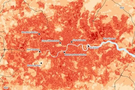 It explained that urban heat islands form when densely packed buildings, roads and other hard surfaces absorb heat from the sun in the day and then fail to release the heat at night in the way that rural areas do.
This is because of lower wind in urban areas due to tall buildings and narrow streets. Higher winds in rural areas carry daytime heat away.
In addition, the lack of trees and water resources reduces the natural cooling effects of shade and evaporation in urban areas.
“Where cities lack sufficient green and blue space to moderate temperatures, this effect intensifies throughout both day and night,” OS said.
It added that, of the top 10 most heat-vulnerable cities today, Leicester is projected to see the biggest rise in its heat vulnerability ranking, climbing from 10th today to fourth by 2100.
“Exeter and Nottingham also rise the rankings to enter the top ten most heat vulnerable cities, alongside Bristol and Brighton and Hove, as rising temperatures reshape the geography of urban heat vulnerability across Britain,” it said.
As a result of the increased vulnerability, there are increased risks to human health, especially to vulnerable groups, such as older people and babies. It will also add pressure to energy infrastructure, transport networks, public services, workplaces and homes.
OS set out to try and understand what was driving the differences in heat vulnerability between different British cities.
It did this by “combining current observed temperatures with the structural characteristics of Britain’s built environment and forward-looking climate projections” into its Heat Vulnerability Index.
That included a temperature score derived from satellite data on heat hazard risks of observed land surfaces compared to their surrounding natural environments, from 4 Earth Intelligence and a climate change score from the Met Office’s UKCP18 climate modelling air temperature projections;
Using the OS National Geographic Database (OS NGD), the index also drew on a built environment score measuring building density, height, connectivity and hard surface coverage and a natural cooling score measuring tree canopy, open vegetation and water bodies.
Ordnance Survey CEO Nick Bolton said: “These findings matter because cities are where millions of people live, work and spend their everyday lives.
“Extreme and sustained heat can affect people’s health and wellbeing, how comfortable our homes and workplaces are, and put additional pressure on transport, energy and emergency services.
“The OS Heat Vulnerability Index shows that by 2040, every city in Great Britain is projected to reach high vulnerability, and by the turn of the century, almost two-thirds could reach the most severe level.
“Understanding how and where this vulnerability is changing depends on an accurate view of how the country is built, based on trusted authoritative data, which is critical for planners, developers and local authorities preparing for a warmer future.”
Main image: Hackney Marshes, London, during drought conditions in August.