Nearly 175 years after it was crushed and abandoned in Arctic pack ice, HMS Investigator is about to get its most detailed digital reconstruction yet. Parks Canada is building a full 3D virtual model of the shipwreck, drawn from more than 150,000 images and sonar scans collected during the most thorough site assessment since the vessel was rediscovered in 2010 – a project expected to reshape how researchers, Indigenous communities, and the public understand one of the Arctic’s best-preserved wrecks.
The model, along with an accompanying archaeological report, is due to be presented this fall to Aulavik National Park, Inuvialuit community members, and the public. Beyond serving as a research and interpretation tool, the 3D reconstruction is expected to shed light on a pressing conservation question: how much longer the wreck can withstand the sea ice that continues to grind against its structure.
A remote survey effort
The data behind the model was gathered in May 2026, when Parks Canada’s Underwater Archaeology Team and Western Arctic Field Unit staff established an ice camp directly above the wreck site in Mercy Bay. A ski-equipped aircraft landed on the sea ice, allowing the team to set up a temporary field camp in one of the most remote regions of the country.
Working through a hole cut in roughly two metres of sea ice, archaeologists deployed a DeepTrekker remotely operated vehicle fitted with a Voyis Discovery Stereo imaging system – equipment loaned by Voyis Imaging of Waterloo, Ontario. The ROV captured high-resolution imagery, video, and three-dimensional data from the wreck, while sonar recordings taken from the ice surface added further detail. The non-invasive approach let the team document the site’s condition in depth without disturbing it.

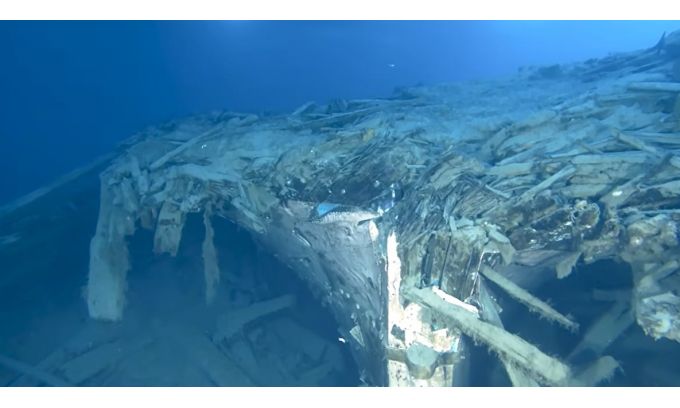
Recent image of HMS Investigator, showing that the topmost timbers of the wreck have been destroyed by ice. (Image courtesy: Parks Canada)
Trapped between ice floes
The survey found that the 36-metre by 9-metre vessel remains upright on the seabed of Mercy Bay, its preservation aided by cold Arctic waters and the shelter of the bay itself. However, the team observed that sea ice continues to interact with both the wreck and its surrounding debris field – a pattern consistent with findings from earlier investigations in 2010 and 2011, suggesting the threat to the site is ongoing rather than diminishing.
HMS Investigator was a merchant vessel purchased in 1848 and pressed into Arctic service alongside HMS Enterprise on an expedition led by James Clark Ross to locate Sir John Franklin’s lost Northwest Passage expedition, which had vanished the previous year. Investigator made two voyages north before becoming trapped between ice floes near Banks Island’s Mercy Bay. After enduring nearly three years of entrapment, the crew abandoned ship on June 3, 1853. The wreck lay undiscovered for more than 150 years until archaeologists located it in July 2010 in the Beaufort Sea.
With survey data now in hand, Parks Canada’s next steps are twofold: compiling a formal archaeological assessment report and building out the detailed 3D virtual model. Together, they are intended to support future research, guide conservation planning, and give both the Inuvialuit community and the wider public a clearer window into a site that has quietly endured Arctic conditions for over a century and a half – for now.