
Severe weather outlook – forecast across Europe. This forecast features areas of organized severe weather with risk levels and severe weather threats across the European continent.
SEVERE WEATHER OUTLOOK
Valid: 27/08/2026 06 UTC – 29/08/2026 06 UTC
Issued by: Severe Weather Europe
Forecaster: Marko Korošec
SUMMARY
*** A significant two-day severe weather outbreak is forecast across portions of western Europe from Thursday through Friday night this week. Moderate to high instability and strongly sheared environments combine for widespread thunderstorm activity with large to giant hail, severe winds, tornadoes, and flash flood potential from Eastern France to western Switzerland and southwestern Germany on Thursday. Followed by additional severe thunderstorm activity across the Alps from southeast Germany, northern Austria to the Czech Republic and southwestern Poland on Friday.***
A large and deep upper-level trough is emerging into western Europe, with a strong blocking High over the Mediterranean region. Between these large-scale features, a powerful southwesterly jet stream is providing ample wind shear, while the air mass beneath it is extremely humid.

This outlook focuses on both Thursday’s and Friday’s evolution, when a significant severe weather event is forecast across eastern and southern France toward the Alps, Germany on Thursday, and Austria, the Czech Republic, and Poland on Friday.
Robust thunderstorms are expected from Thursday afternoon through Friday evening.
Above: Video animation of the convective storm’s development across Central Europe from Thursday through Friday night, August 27th and 28th, 2026.
For this reason, HIGH + MDT risks have been placed across portions of France, Switzerland, Germany, the Czech Republic, and Poland, with highlighted areas where the most robust severe weather threat will develop on both days. The threat includes enhanced potential for severe damaging winds, flash floods, tornadoes, and very large to giant hail (6-10 cm or larger).
SYNOPTIC OVERVIEW
This week’s weather pattern over Europe shows the underlying risk to France on Thursday. As a strong upper-level ridge builds over the Mediterranean, Central Europe, and the Balkans, a deep wave over western Iberia creates a significant pressure and temperature gradient between the two large-scale features.
This significantly amplifies southwesterly jet-stream winds from eastern Spain across the western Mediterranean into southern and eastern France, providing violent wind shear.
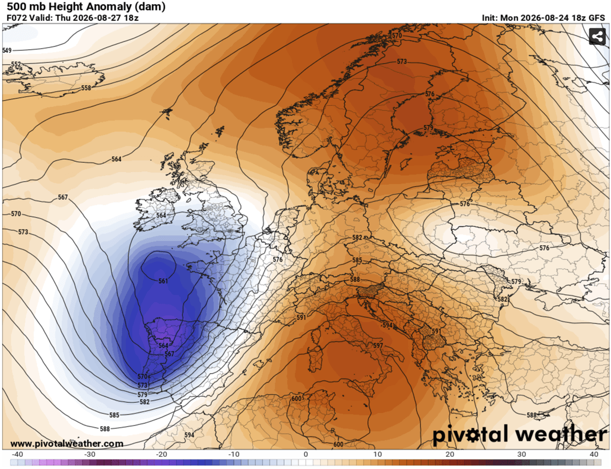
This results in a frontal system entering France, with the cold front moving west to east towards Germany and the Alps from Thursday midday through Friday night.
WEATHER FORECAST DISCUSSION – Thursday, August 27th
+++ Weather forecast for France, Switzerland, and Germany +++

Explanations for abbreviations (TSTM, SLGT, ENH, etc.)
Highlighted severe weather threats:
Tornado potential: High
Maximum hail size: More than 8 cm
Peak wind gusts: Up to 120 km/h
24-hour rainfall: Up to 100 mm
HIGH risk has been issued for east-central France, western Switzerland and southwestern Germany for an outbreak of severe thunderstorms. The threat includes severe damaging winds, very large to giant hail, torrential and excessive rainfall with flash floods, and tornadoes.
MDT/ENH risks have been issued for areas surrounding the HIGH risk areas, including most of France, Switzerland, northwest Italy, western Austria, southern, central and western Germany, and the Benelux, with a threat for severe winds, large hail, and torrential rainfall. The expected storm coverage is forecast to be lower than inside the highlighted purple risk area.
Ahead of an emerging frontal system from the west, powerful westerlies aloft are advecting high moisture from the western Mediterranean region into southern and southeastern France. Given the ongoing extreme Mediterranean heatwave, high dewpoints will result in moderate to locally extreme instability, with MLCAPE reaching 2000 to 4000+ J/kg over southeastern France.
At the same time, ample wind shear is also overspreading the region, thanks to the intense jet mid-level stream aloft. Therefore, a strong forcing develops near the left-exit region of the jet.

A combination of intense wind shear and high instability will create a volatile environment, with explosive development of severe thunderstorms from midday Thursday, starting over the Massif Central and spreading into the Rhone valley, where southerly moist winds will transport high dewpoints northward. Isolated but intense supercells are expected as the primary mode, supporting rapid development of severe threats, large to very large hail, damaging winds, and torrential rainfall.
Strong southeast low-level flow also hints at tornadic supercells. The tornado threat is maximized across the Rhône Valley portions of the HIGH risk area in southeast France, where the highest storm-relative helicity and low-level shear will be present. Storms will move east-northeast quickly, with intense winds aloft, spreading toward western Switzerland and southwestern Germany into the evening.
Through Thursday night, storms will be merging into large cluster(s) while continuing northeast into southwestern and central Germany. Given the high wind shear and instability, large wind-driven hail, severe damaging winds, and torrential rainfall will be the main threats.
Another area of enhanced storm activity is to the north of the wave axis as it moves toward the Benelux and Western Germany late afternoon into the evening, supporting widespread storm activity as storms cluster. Severe winds and torrential rainfall will be the primary threat, while tornado potential also exists.
Isolated severe storms are also possible across southern England near the wave crossing during peak heating, with moderate instability and relatively strong shear in place.
WEATHER FORECAST DISCUSSION – Friday, August 28th
+++ Weather forecast for Switzerland, Germany, Austria, Italy, Czech Republic and Poland +++

Explanations for abbreviations (TSTM, SLGT, ENH, etc.)
Highlighted severe weather threats:
Tornado potential: Medium
Maximum hail size: More than 8 cm
Peak wind gusts: Up to 120 km/h
24-hour rainfall: Up to 100 mm
MDT risk has been issued for eastern Switzerland, Austria, the Alpine region, the Czech Republic, and southwestern Poland for an outbreak of severe thunderstorms. The threat includes severe damaging winds, very large to giant hail, torrential and excessive rainfall with flash floods, and tornadoes.
ENH/SLGT risks have been issued for areas surrounding the MDT risk areas, including southeast France, northern Italy, western Slovakia, west-central Poland, and eastern Germany, with a threat for severe winds, large hail, and torrential rainfall. Expected storm coverage is forecast to be lower than within the highlighted purple risk area.
Isolated thunderstorms will initiate over the Alps during the early afternoon, supported by moderately strong instability and amplified wind shear. Intense multicells and supercells will be the primary storm modes before the activity clusters into one or two large convective systems towards the evening hours.
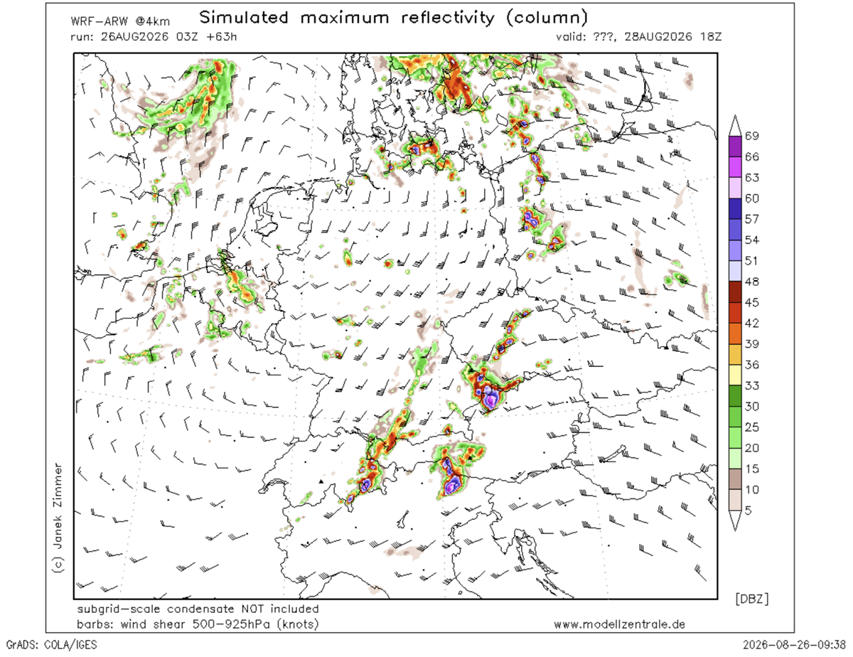
This is a great concern, but it is also uncertain how intense and large the mesoscale convective system (MCS) will develop from southeastern Germany and northeastern Austria into the southwestern Czech Republic. Some high-resolution models hint at a violent wind-gust potential from the bowing segments, clustered off the supercells earlier.
If this occurs, destructive winds may develop and exceed 120 km/h, producing widespread severe wind damage across the MDT risk area and spreading northeast into southwestern Poland overnight.
Meteoadriatic, Wxcharts, and PivotalWeather provided images used in this article.