
An impartial OSINT dossier on Saudi Arabia, Jordan, Kuwait, the United Arab Emirates and Bahrain: military capabilities, eyewitness accounts and economic consequences.
Abstract
Iranian attacks on U.S. military installations in the Middle East during Operation Epic Fury caused verifiable damage far beyond what emerged in the very first official statements. The 22 October 2026 investigation by Aaron Parnas and Ken Harbaugh for MeidasTouch and VALOR Media adds photographs and accounts from service members, contractors and family members to earlier satellite-based investigations, but the allegations do not all meet the same evidentiary standard. By reviewing more than one hundred images and cross-checking against Copernicus and Planet imagery, The Washington Post had already identified at least 217 structures and 11 pieces of equipment damaged or destroyed across 15 locations as of 14 April. The Congressional Research Service subsequently catalogued 81 aircraft lost or damaged during the campaign through 5 October, including accidents, friendly-fire incidents, drones and aircraft later repaired. The central issue is not merely to count the destruction. It is to determine how the exposure of fixed bases affected force protection, interoperability, resupply, deterrence and the cost of restoring capabilities.
Methodological Note
VISUAL EVIDENCE NOTICE: The three photographs actually embedded in this edition are archival military images; they are not photographic evidence of the strikes themselves. Photographs and satellite imagery of specific strike damage credited to the BBC, CBS, AFP/Planet Labs and MeidasTouch are identified and linked in the OSINT register, but the original files are not embedded because they were not available for inclusion. These must not be confused with the analytical charts produced by IARI.
This dossier triangulates accounts collected by journalists from sources who are not publicly identified, photographs accessible online, geolocation checks published by independent newsrooms, institutional records and specialist assessments. A photograph of a ruined building documents its physical condition and, if geolocated, its location; it cannot by itself prove when it was struck, what weapon caused the damage or which order commanders issued. Anonymous statements are attributed to the outlet that obtained them and are not presented as judicial findings. The confidence scale differentiates A, visually and independently verified; B, corroborated by several but incomplete lines of evidence; C, insufficiently verified allegation; and D, analytical hypothesis. Selected visual sources are described in the OSINT register with their origin, what they establish, what they do not establish and their reliability. IARI’s original charts are explicitly labelled analytical diagrams rather than satellite photographs. They are no substitute for forensic examination of the source files: the complete raw archive, original metadata and military telemetry are not available to this investigation.
Introduction
On 28 February 2026, the United States and Israel began military operations against Iran. Iran’s response reached installations associated with the U.S. military presence across a broad regional geography: Kuwait, Bahrain, Qatar, the United Arab Emirates, Saudi Arabia and Jordan. Their vulnerability must be examined against two dynamics: the disparity between America’s overall military power and Iran’s asymmetric options; and the Gulf states’ reliance on energy, logistics and commercial infrastructure located within reach of regional missile systems. The war thus placed both a military network and a regional political economy under stress, rather than merely a set of airfields.

FIGURE — Crisis timeline. Sources: CRS, DoD, MeidasTouch, AP. Limitation: shows a selected, non-exhaustive sequence of events.
Comparing the Two Economies: United States and Iran
Direct economic relations between Washington and Tehran are extremely limited, reflecting decades of sanctions and restrictions. For 2025, the U.S. Census Bureau records $58.7 million in U.S. goods exports to Iran and $1.4 million in imports; the Office of the U.S. Trade Representative estimates total trade in goods and services at approximately $724.1 million. These sums are marginal relative to gross domestic product: according to the World Bank, U.S. nominal GDP in 2025 was approximately $30.77 trillion, compared with roughly $363 billion for Iran, a ratio of about 85 to 1. A nominal GDP comparison measures economic scale at current exchange rates, not domestic purchasing power or warfighting potential, which also depends on doctrine, industry, sanctions constraints and geography.

FIGURE — U.S.–Iran economic comparison. Source: World Bank; IARI analysis. Limitation: nominal GDP does not translate proportionally into military capability.
The Indirect Economic Connection: Energy and the Gulf
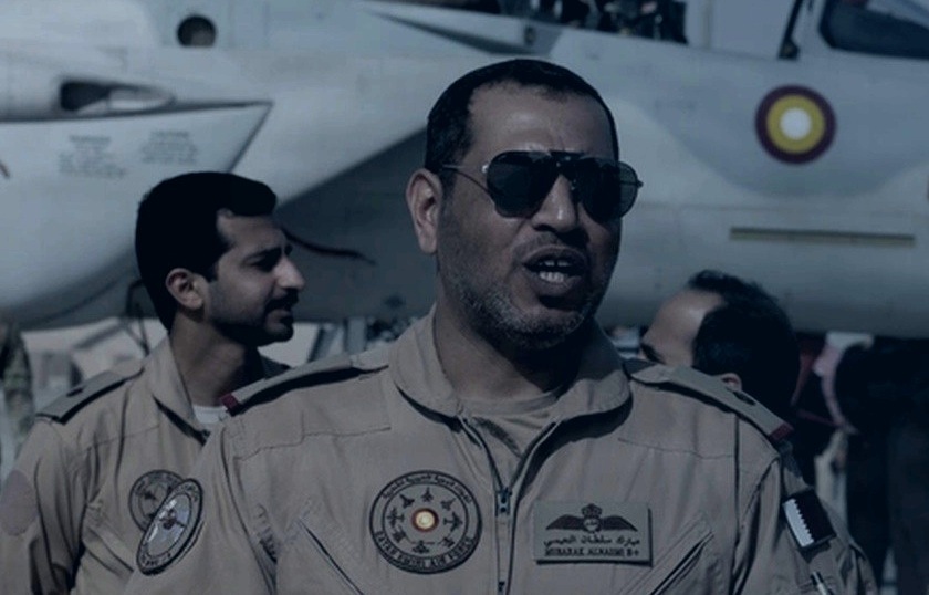
CONTEXT PHOTOGRAPH — Personnel and an aircraft at Al Udeid Air Base, 11 February 2026. Source: U.S. Air Force / DVIDS, Tech. Sgt. Christopher Thornbury. Cropped from an image previously archived in an IARI dossier. Does NOT document damage from Epic Fury.
The near-absence of direct trade does not mean the two economies are insulated from each other. The strongest economic consequences of the conflict are transmitted through energy prices, the Strait of Hormuz, marine insurance, aviation, ports and public security expenditure. According to the IMF’s July assessment, the effective closure of Hormuz disrupted a corridor that had carried roughly 20 million barrels of oil and petroleum products per day before the war. Gulf countries have different levels of exposure: some have pipelines and alternative outlets that can bypass the strait, while others remain heavily reliant on regional terminals. For Iran, the conflict intersects with constrained energy exports and the burden of sanctions; for Washington, it entails expenditure on munitions, air defence, allied protection and replacement equipment. It is therefore more accurate to describe economic asymmetry and strategic interdependence transmitted through global markets than two directly integrated economies.
Evidence Corpus — Reconstructing the Record
The comparative investigation covers five geographical areas while treating them as parts of a single distributed architecture. The principal figures refer to different datasets and must not be added together: 228 is the minimum number of structures and items of equipment detected in available imagery through April across a sample of sites; 81 refers to aircraft lost or damaged through October for a variety of causes; $3.7 billion is the upper end of an estimated equipment-loss figure in the Inspector General’s report; and the full cost of rebuilding the bases has not been comprehensively disclosed.

FIGURE — OSINT evidence matrix. Source: IARI assessment drawing on news and institutional sources. Limitation: categorises confirmed, corroborated and unverified claims.
Saudi Arabia: Prince Sultan and the Loss of an AWACS
Photographs of the destroyed E-3 Sentry at Prince Sultan provide some of the strongest evidence in the entire case. The BBC verified that the images were taken at the Saudi air base, while other reconstructions describe the destruction of the fuselage and rear section. The documented serial number is 81-0005; the MeidasTouch report uses the shorter form 81-005. This variation in transcription does not justify counting a second aircraft. The E-3 is an airborne surveillance, early-warning and coordination platform. Its loss is not equivalent to that of a routine transport aircraft because it removes a high-value command-and-control asset. The CRS also records damage to KC-135 tankers during the campaign; each event must be identified separately to avoid double-counting.
Shelters, Facilities and the Alleged C-17 Loss
MeidasTouch materials include images said to show barracks, dining facilities, operational areas and unfinished shelters. One image appears to show doors not yet installed on a bunker: it can establish a physical condition at the time of the photograph, but not that all personnel were systematically without shelter or that this bunker was assigned to service members during a particular strike. The same outlet presents alleged C-17 wreckage and reports claims of concealment; its authors acknowledge that they could not independently verify the loss. Without an aircraft serial number, independently geolocated imagery and corroboration in loss records, the C-17 claim remains at confidence level C. The alleged motive for moving the wreckage likewise cannot be treated as established fact. [F01]
Jordan: Muwaffaq Salti and Operational Continuity

CONTEXT PHOTOGRAPH — U.S. medical personnel in a 2022 archival image previously included in the IARI IRGC/Nasr-2 dossier. Source: U.S. military archive / DVIDS. This does NOT depict the 17 July 2026 strike or its aftermath.
Public reporting documents multiple attacks on Muwaffaq Salti Air Base, including strikes on air-defence infrastructure. The MeidasTouch account describes repeated alarms over several months, damage to accommodation and supply difficulties. Claims that service members could not reach shelters must be weighed against the locations of impacts and the alert procedures that were in place. The deaths of three U.S. service members in the 17 July attack are supported by reporting independent of MeidasTouch. Aircraft losses are a separate question: the CRS records damaged F-15s, some subsequently repaired, and other incidents spread across the theatre. Without verified dates, aircraft identifiers and locations, it would be unsound to attribute every mentioned F-35 or MQ-9 incident to this Jordanian base. [F01] [F03]

FIGURE — Regional map of the bases discussed. Source: Basemap/GSHHS geographical data and publicly reported locations. Limitation: approximate public locations only; no targeting or impact locations shown.
Kuwait: Camp Buehring, Arifjan and the Port Shuaiba Attack
At Camp Buehring, CBS obtained video and testimony and checked the available evidence through metadata and on-the-ground verification. Sources describe missile and drone attacks, ammunition shortfalls and the movement of units into desert areas. Some of this relocation was a deliberate effort to disperse forces and reduce exposure at fixed sites; it should not automatically be characterised as a rout. According to CBS, no personnel died from enemy fire at Camp Buehring or in the follow-on positions it examined, although there were injuries and other incidents during deployments in the desert. [F05] [F06]
Port Shuaiba: Inadequate Protection or Accepted Risk?
On 1 March, an Iranian attack on a U.S. operations centre near the civilian port of Shuaiba killed six service members. An AP investigation based on interviews with military personnel and relatives of those killed documented earlier concerns about drones, shelters and emergency procedures. The investigative question is not merely whether the struck facility existed, which imagery can establish, but why personnel were stationed at such an exposed location, which alternatives were genuinely available and whether orders reflected the risk assessment at the time. Some officers defend the decisions taken, citing the requirement to maintain logistics operations. Any definitive assignment of responsibility depends on the complete internal investigation, not simply a photograph of the impact site. [F04]
United Arab Emirates: Al Dhafra and Missile Defence
Satellite observations published by independent outlets indicate damage to structures and equipment associated with radar and missile-defence systems in the UAE. The Washington Post includes Emirati locations among the damaged sites, linking some strikes to THAAD-related infrastructure. A destroyed or damaged radar can weaken local resilience and force the relocation of other resources; it does not by itself establish that the entire regional network was blinded. MeidasTouch describes personnel who allegedly sought shelter in hotels or dug individual fighting positions without adequate orders. Such accounts are relevant evidence about preparedness, but they do not replace operational directives and personnel records. [F01] [F02] [F14]

FIGURE — Operational impact pathways. Source: IARI synthesis of CRS, CBS and The Washington Post. Limitation: analytical relationships, not a reconstruction of specific missions.
Bahrain: The Fifth Fleet and the Logistical Cost of Damage
Planet Labs imagery from 1 March and subsequent journalistic investigations clearly show damage to the Naval Support Activity Bahrain complex in Manama. The Washington Post documents damage to communications infrastructure, a qualitatively different consequence from the loss of recreational or administrative buildings. The destruction of fixed equipment can lengthen resupply routes, require substitute systems and force the reassignment of personnel and activities. Journalistic sources report changes to naval logistics; however, these effects must be kept distinct from any overall assessment of the Fifth Fleet’s combat capability. [F02] [F14]
Family Evacuations and Responsibility for Decisions
The MeidasTouch investigation describes families sheltering in car parks, difficult transfers and extended uncertainty; other reporting documents that some families had not been evacuated before hostilities began. The occurrence of delays or difficulties does not in itself prove the more serious allegation that a particular authority deliberately blocked evacuations for political or media reasons. Establishing that would require decision logs, official communications and a chronology of orders. The human testimony must therefore be taken seriously without turning an explanation attributed to an anonymous source into a judicial finding. [F01]
Assessing the Losses: Compatible and Incompatible Figures
The Washington Post identified 217 structures and 11 items of equipment hit across 15 installations, based on a partial body of imagery available through mid-April. The CRS counted 81 aircraft lost or damaged through October, including fixed-wing aircraft, helicopters and unmanned systems, some of which returned to service, and incidents attributable to causes other than Iranian fire. The Lead Inspector General report published on 14 September recorded equipment losses valued at up to roughly $3.7 billion over its reporting period; this is not a final estimate of reconstruction costs. On 19 October, five senators asked CENTCOM to release a base-damage estimate presented to them during a classified briefing, requesting a response by 2 November 2026. Confusing these four scopes would produce an artificially inflated total. [F02] [F03] [F07] [F08]

FIGURE — Losses and statistical scopes. Sources: The Washington Post, CRS and DoD Inspector General. Limitation: compares three distinct metrics that cannot be added together.
The Strategic Vulnerability of Permanent Bases
The geography of the U.S. military presence in the Gulf offers logistical and diplomatic advantages, but also concentrates people, depots and communications at highly visible locations. Surveillance and interception networks are effective only when they integrate defences against different threats, from ballistic missiles to slow, low-flying drones, alongside shelters, redundancy, dispersal procedures and logistical continuity. An attacker can achieve consequential effects without destroying all defences: striking a rare asset, a system with no backup or a crowded facility may suffice. Conversely, damage to buildings following a preventive evacuation must not be equated with the same magnitude of combat-power losses. The variable that matters is the time required to sustain or restore critical functions, rather than merely the burned area visible from above. [F02] [F05]
Speculative Hypothesis
The central hypothesis is that Epic Fury may accelerate a transition from a posture centred on large permanent garrisons to a more distributed, redundant and mobile regional presence. This is not a prediction that bases will close across the board: airfields, access agreements and storage facilities remain indispensable. Rather, it concerns reducing the operational value of any single fixed target through compartmentalisation, short-range counter-UAS defence, rapid repair capability, decentralised communications and relocation of high-value assets. Accounts of service members’ conditions further suggest that the human dimension—warning systems, shelters, family support and command chains—must be included in resilience assessments rather than treated as secondary. This is an analytical inference, not an approved Pentagon plan. [F01] [F02] [F05]
So What — Hypotheses, Impacts and Strategies
Under the adaptation scenario, Washington and its allies increase investments in counter-drone protection, logistical dispersion, alternative sensors and the protection of high-value infrastructure. Unit protection costs rise, but the risk of disruption to essential functions may decline. Under a fragile-stability scenario, bases remain active with smaller staffing levels and selective protection: further Iranian strikes could damage facilities without paralysing the whole system, while drawing down stocks and driving repair expenditure. Under a renewed-escalation scenario, concurrent attacks on military systems and energy infrastructure magnify effects on insurance premiums, maritime routes and fuel availability. The U.S. strategic response might combine defensive capability, dispersal and diplomatic risk management with host countries. None of these scenarios is a certain outcome. [F02] [F12] [F13]
Implications for Italy, NATO and Europe
For Italy, the main effects are indirect but tangible: volatile energy supply, maritime transport costs, protection of lines of communication and the availability of allied military resources for other theatres. The resilience of U.S. bases also offers a case study in dual-use infrastructure, layered air defence and protection of deployed personnel. Lessons from the Gulf cannot, however, be transferred automatically to NATO bases in Europe, where the environment, threats, command arrangements and geometry of defence differ. For Rome, the main relevance therefore concerns planning standards, logistical dependencies and the opportunity cost of resources. [F12] [F13]
Conclusions
Currently verifiable information shows significant damage to U.S. bases and demonstrates an Iranian ability to hit identifiable military objectives. The new MeidasTouch imagery adds testimony on protection problems and personnel conditions; it does not automatically turn every reported loss into a verified fact. Allegations of deliberate concealment, the loss of a C-17 and politically motivated evacuation decisions remain open questions requiring documentary investigation. The strikes may have imposed substantial tactical and logistical costs without proportionately reducing overall U.S. offensive capacity. For that reason, claims of ‘defeat’ cannot be inferred merely by adding up buildings that were hit. An impartial assessment must preserve at once the evidence of damage, uncertainty about commanders’ responsibility and the record of continued U.S. operations. [F01] [F02] [F03]
Indicators to Monitor in the Short, Medium and Long Term
In the near term, a key test will be whether CENTCOM releases the unclassified base-damage estimate requested for 2 November 2026, and how its scope compares with the losses already disclosed. Over subsequent months, investigators should examine the outcomes of internal inquiries into Port Shuaiba; the identities and operational status of affected aircraft; the return of personnel and infrastructure to service; and changes to protection and evacuation procedures. Longer-term indicators include timelines for replacing rare radar systems and aircraft, industrial capacity to replenish interceptors, contracts to harden installations, the share of functions redistributed away from major hubs and changes to access agreements with host nations. Analysts must distinguish announcements, appropriations, physical deliveries and capabilities that are actually operational. [F03] [F07] [F08