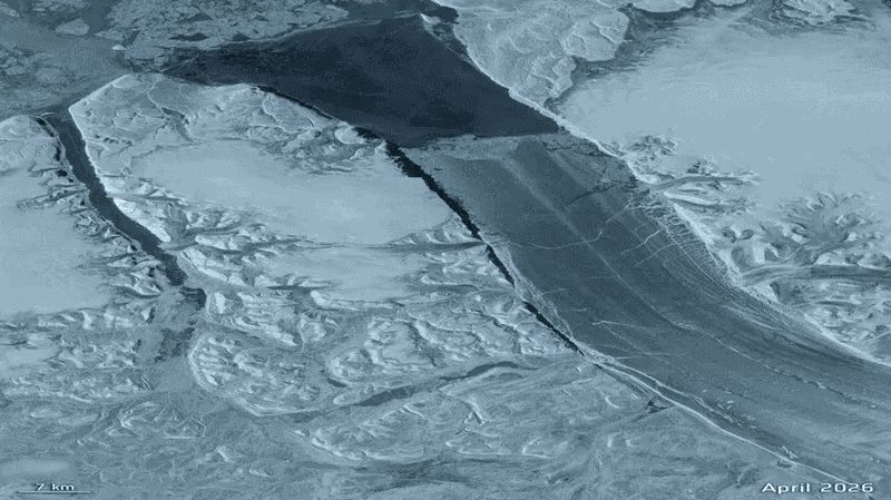
A gigantic chunk of Greenland just broke free, and it’s roughly the size of Manhattan.
The 29-square-mile section of Petermann Glacier snapped off earlier this month, creating a massive tabular iceberg, or “ice island.”
Scientists estimate the slab could be nearly 500 feet thick.
Satellites watched it happen
Europe’s Copernicus Sentinel-1 mission captured cracks spreading rapidly through the glacier weeks ago.
By Aug. 3, the area was showing major deterioration. On Aug. 4, the slab completely separated.

Satellite image of a frozen river or fjord with ice cracks and snow-covered terrain, dated April 2026 with a 7 km scale bar
This particular glacier hasn’t experienced a break this large since 2012, making this its biggest ice loss in more than a decade.
Why you should care
Greenland’s ice sheet holds enough frozen water to raise sea levels around the world by more than 20 feet if it were to melt completely, so it’s worth keeping an eye on.
(MORE: Couple gets married among Greenland glaciers)
While one iceberg breaking away won’t make sea levels suddenly rise, it’s a reminder that changes happening thousands of miles away can eventually show up on your doorstep.
Rising seas can mean more coastal flooding, erosion and damage to homes and infrastructure. For people living near the coast, that can translate into higher insurance costs, more flood risk and tougher decisions about where and how to build.
Risk to this glacier isn’t over
Scientists say two even larger pieces, estimated at about 37 and 33 square miles, could eventually break away as existing cracks continue spreading.
For now, researchers will track the Manhattan-sized ice island as it drifts through the Atlantic, breaks apart and potentially affects Arctic shipping.