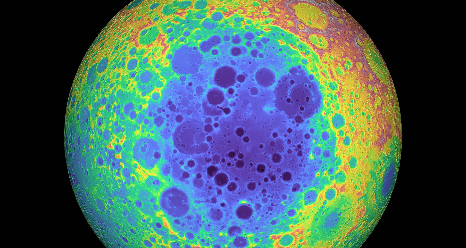
New research says the Moon’s largest and deepest impact crater, known as the South Pole-Aitken basin (SPA), sits on its far side. A new study demonstrates that the SPA was formed by an asteroid coming in from a northern direction, upending current beliefs.
The basin is 250 miles deep, spanning more than 1,200 miles north to south and 1,000 miles east to west. It straddles the rugged terrain around the lunar south pole.

The SPA’s outline is not a neat oval. It tapers toward the south, a hallmark of oblique impacts where the downrange end narrows.
That taper, together with a slow fade in topography and crustal thickness to the south, points to a north to south trajectory. It also marks the south as the place where debris blasted out by the impact piled up thickly.
The work was led by Jeffrey C. Andrews-Hanna of the University of Arizona’s Lunar and Planetary Laboratory (LPL). It blends shape, signals, and impact physics into one testable story.
Shapes of other giant basins back the pattern. Hellas on Mars and Sputnik on Pluto also narrow in their downrange direction.
KREEP in the South Pole-Aitken basin
To make sense of what the impact unearthed, meet KREEP, a leftover mix of potassium, rare earths, and phosphorus. It formed from the Moon’s ancient magma.
KREEP tends to cluster on the near side, where it kept rocks warm and mobile. One tracer of KREEP is thorium, a heat producing radioactive element visible to orbital detectors.
The new map around South Pole-Aitken shows thorium rich material in the southwest ejecta and little to the northeast.
Another piece of the puzzle is the Moon’s lopsided crust. The far side’s crust is thicker than the near side, as shown by NASA’s GRAIL mission.
This pairing of composition and structure sets up a clear test. If thorium is concentrated only where the crust was once thin, the enrichment likely records the last pools of molten rock. Those pools formed before the surface locked up.
Concentrated leftovers
During the Moon’s earliest era a magma ocean cooled. It then turned to rock. Late in that process, small pockets of KREEP remained in some places. These pockets stored heat and unusual elements close to the surface.
The new analysis argues that, at impact time, a thin layer of liquid magma persisted beneath the basin’s southwestern half. That explains the thorium rich ejecta there.
Samples from China’s Chang’e 6 mission support this split picture. The lander collected material in the northeastern part of the South Pole-Aitken basin, and reports show little KREEP in that mantle source.
“Our study shows that these samples may reveal even more about the early evolution of the moon than had been thought,” said Andrews-Hanna.
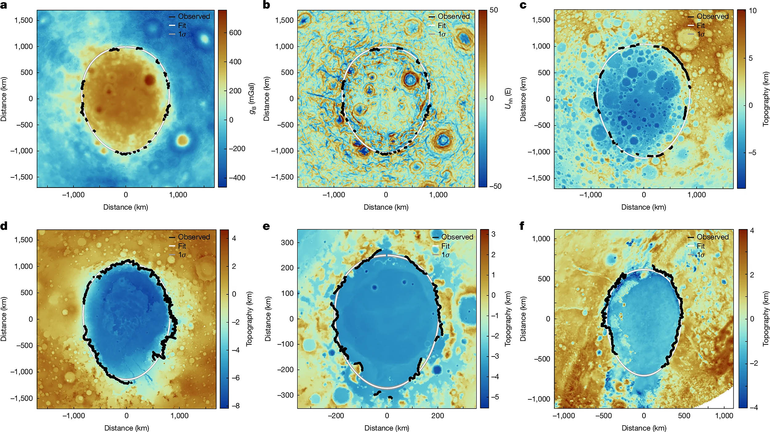 Maps of the South Pole–Aitken (SPA) basin in Bouguer gravity (a), gravity gradients (b) and topography (c) in comparison with topographic maps of the Hellas basin on Mars (d), the Crisium basin on the Moon (e) and the Sputnik basin on Pluto (f). All figures are in a basin-centred polar projection with basins oriented with the inferred downrange direction to the bottom. The rim picks are traced in black, with the mean and 1σ fits for a tapered ellipse in white and grey. The tracing in a and b are the same, based on a combination of the two datasets. Click image to enlarge. Credit: NatureArtemis crew at the South Pole-Aitken
NASA plans to send astronauts to the south polar highlands within the basin’s downrange rim. Mission briefings emphasize sampling impact debris and volatile rich terrains.
Rocks from thorium rich ejecta could lock in ages and reveal how far the basin dug. They also test how KREEP moved from the South Pole-Aitken basin across the Moon with time.
Field teams can target boulders and layers perched on crater walls. Those layers sort deep material by distance and grain size, which helps reconstruct the order of excavation.
Careful ages from melt rocks would bracket the timing of magma ocean solidification. That timing frames how long the Moon stayed hot enough for big changes inside.
History told by the South Pole-Aitken basin
Together, these lines of evidence connect shape, chemistry, and heat flow into one story. A glancing strike from the north sculpted the basin, and it spattered up ingredients that trace a cooling planet.
The scenario also helps explain why the near side turned dark with seas of lava while the far side stayed bright and rugged. The pattern follows where heat producing elements pooled long ago.
The south polar setting adds a practical bonus for exploration. High ridges offer long sunlight, while nearby shadows may trap ice in cold ground.
That combination, science and resources, is rare on the Moon. It is why multiple space agencies keep circling the same rugged turf.
If astronaut teams bring back rocks from the south polar rim, laboratories can read their textures, minerals, and isotopes with precision. Those measurements reveal pressure, temperature, and time, which together outline the impact’s deepest cut.
The same approach can be used across our solar system. Tapered basin rims and chemical gradients act as signposts that point to impact angles, excavation depths, and hidden reservoirs of heat producing elements.
The study is published in Nature.
—–
Like what you read? Subscribe to our newsletter for engaging articles, exclusive content, and the latest updates.
Check us out on EarthSnap, a free app brought to you by Eric Ralls and Earth.com.
—–