Weather experts warn that a potentially severe storm is increasingly likely to hit Ireland, with risks of power outages, falling trees and broadband disruption in the worst-affected areas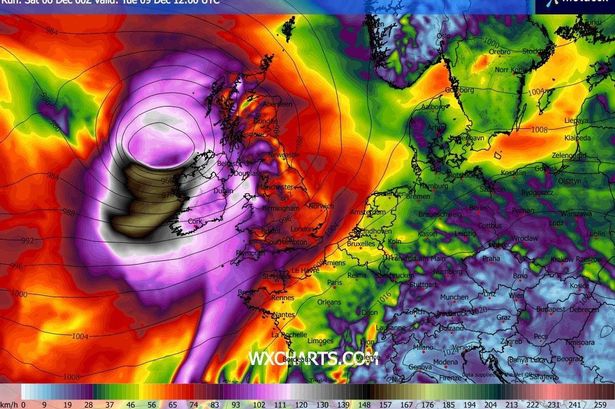 Ireland facing potential storm next week
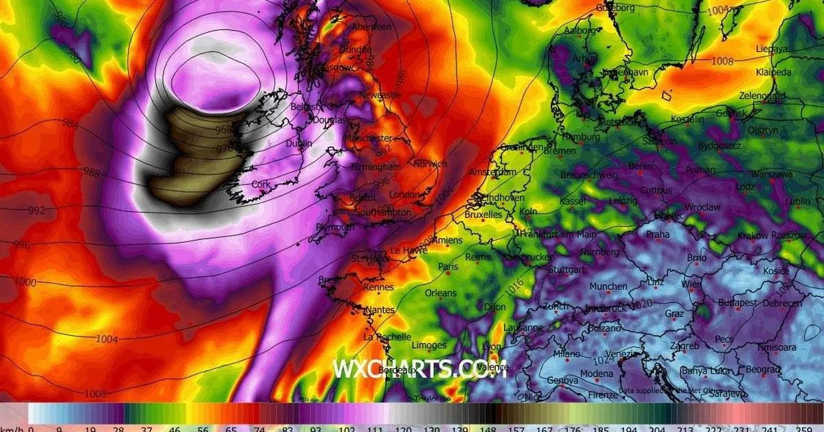
A prominent Irish meteorologist has issued a warning about a “potentially severe” storm approaching Ireland at the start of next week.
In a Saturday update, Cathal Nolan from Ireland’s Weather Channel indicated that the likelihood of a storm striking Ireland on Tuesday is “increasingly likely”, with the possibility of power cuts, fallen trees and interruption to broadband services in the most severely affected regions.
The storm warning comes as the UK Met Office has put in place a Status Yellow rain warning for all six Northern Ireland counties – Antrim, Armagh, Derry, Down, Fermanagh and Tyrone. Significant rainfall is anticipated to cause some disruption on Sunday morning and afternoon, with the alert active from 8am to 3pm.
Looking beyond the weekend, considerable uncertainty remains regarding the precise trajectory and strength of the adverse weather system heading towards Ireland, with Met Éireann highlighting “an unusual amount of uncertainty” in its forecast for potentially strong winds from Monday night into Tuesday.
Nolan acknowledges this uncertainty in his update, whilst also noting that a scenario now appearing more probable, one also highlighted by the UK Met Office on Saturday, involves a storm making its most significant impact on Ireland during Tuesday, reports the Irish Mirror.
If a storm is officially named, it would be designated Storm Bram, marking the second named storm of the season following Storm Amy in early October. “It’s increasingly likely that a strong area of low pressure, a storm depression, is going to pass to the west of Ireland as we go late into Monday night and particularly so during Tuesday, with extremely strong winds potentially for western parts, leading to power outages, leading to the possibility of broadband damage as well as leading to the felling of trees and transport disruption,” said Nolan.
The forecaster warned that southern, western and northwestern regions would probably bear the brunt of the storm if it materialises, though all areas would experience very powerful winds.
Earlier on Saturday, Irish weather expert Alan O’Reilly of Carlow Weather, who has been regularly updating the public on the approaching storm in recent days, commented: “Latest weather model updates for Tuesday continue to show uncertainty on the track of potential storm. The UKMO model has the worst outcome this morning.
“The conveyor belt of low systems will continue coming across the Atlantic with risk of more storms this coming week.”
Join our Dublin Live breaking news service on WhatsApp. Click this link to receive your daily dose of Dublin Live content.
We also treat our community members to special offers, promotions, and adverts from us and our partners. If you don’t like our community, you can check out any time you like. If you’re curious, you can read our Privacy Notice .
For all the latest news from Dublin and surrounding areas visit our homepage.