Few instruments have explored Mars with such precision. Through the razor-sharp eye of HiRISE, the Mars Reconnaissance Orbiter has been decoding the Red Planet, uncovering extraordinary geology and long-hidden secrets preserved in landscapes shaped over billions of years.
For nearly two decades now, the Mars Reconnaissance Orbiter, known as MRO, has been circling Mars. Over these 20 years, it has examined the Martian surface in remarkable detail thanks to its suite of high-resolution instruments. With the HiRISE camera on board, the probe can spot features as small as 25 to 30 centimeters per pixel from orbit, producing images that are both stunning and, at times, completely unexpected.
The sharp eye that examines Mars in the finest detail
Day after day, MRO systematically maps the planet, tracking the shapes of dunes and craters, the paths of geological faults, and sedimentary deposits that point to ancient flows of liquid water on the Martian surface.
The spacecraft can also identify hydrated minerals such as clays and sulfates using the CRISM instrument, while SHARAD allows scientists to peer beneath the surface in search of buried ice. Together, these observations offer crucial insight into Mars’ watery past and help lay the groundwork for future missions—some of which may one day be human.
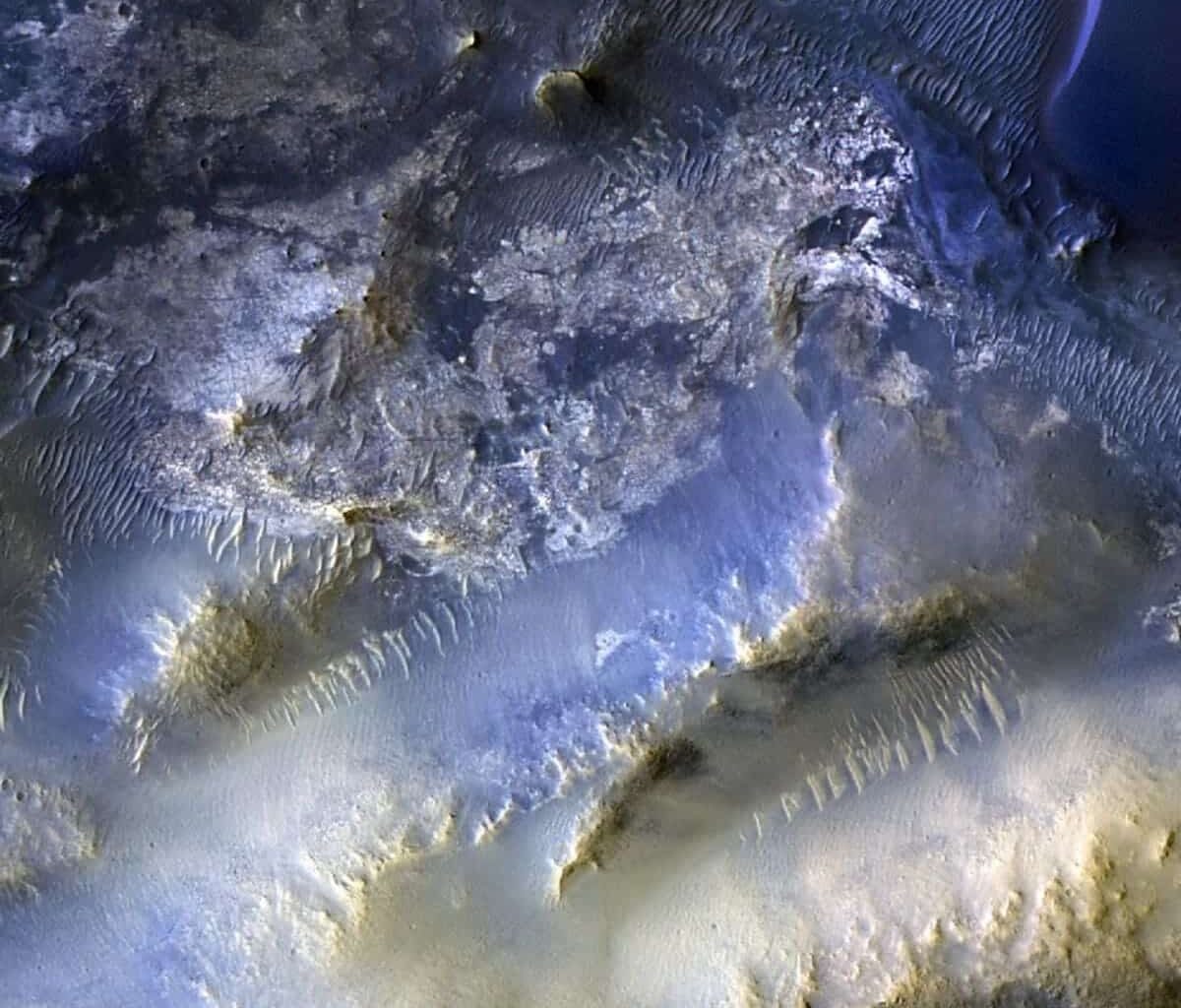
Dune field inside a small crater five kilometers in diameter in the northern plains of Mars. Photo taken by MRO (HiRISE). © NASA, JPL, University of Arizona
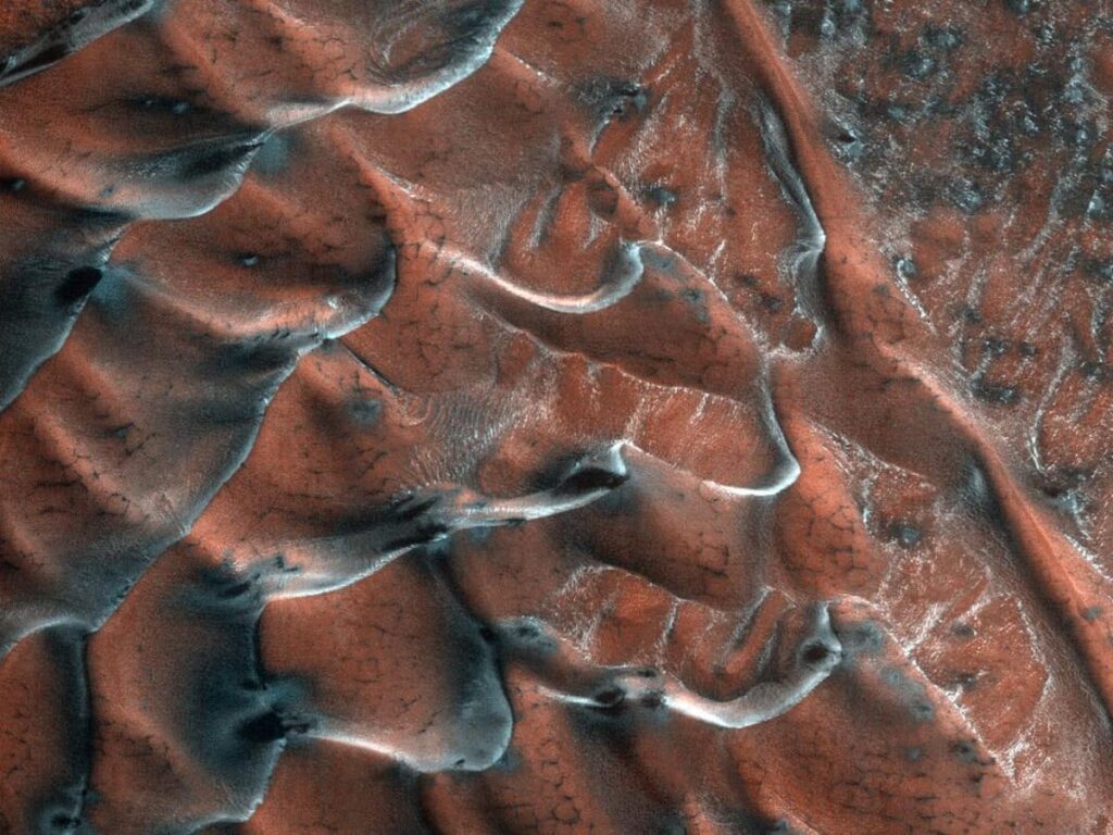
The 100,000th image reached in October
On October 7, MRO marked a major milestone by capturing its 100,000th image. The target was Syrtis Major, a region located roughly 80 kilometers southeast of Jezero Crater, where the Perseverance rover is currently exploring.
As so often with HiRISE images, this one is packed with valuable information. It reveals a landscape dominated by mesas—flat-topped formations with steep sides carved by erosion. Across the plains, countless wind-shaped dunes appear, their forms and orientations changing from place to place. These details are essential for understanding local wind directions and climate patterns on Mars.
Discover the remarkable images captured by HiRISE, the high-resolution camera aboard NASA’s Mars Reconnaissance Orbiter, including its 100,000th image showing the plains and dunes of Syrtis Major. © NASA, JPL-Caltech, University of Arizona
One particularly striking detail is that this landmark HiRISE image was not suggested by NASA scientists themselves. Instead, it was proposed by a student through the HiWish platform.
Through this citizen science initiative, NASA invites the public to recommend locations for observation—a simple yet powerful way of making the exploration of another planet feel

Morgane Gillard
Journalist
As a child, I dreamed of being a paleontologist, an astronaut, or a writer… and ultimately, my heart led me to geology. After years of studying to gain deep knowledge, I now share it with you, the readers of Futura!
Looking back, I realize that my passion for Earth and science in general started very early! My first spelunking expedition was at the age of 4, my first scuba dive at 7, fossil hunting all across France, nighttime outings to watch the stars… With a father who was a chemistry teacher and an avid cave diver, and a mother who was the first female commercial diver in France, my childhood was filled with adventure and discovery! One memory in particular stands out: observing the Hale-Bopp comet in 1997, in the middle of the night, standing in a field while my parents whispered the countdowns for the exposure times to photograph that strange celestial object lighting up the sky. That image is forever etched in my memory, a moment filled with a certain magic—and even today, I still get chills when I gaze up at the stars. Head in the stars, feet on the ground. It was probably during our travels in an old Volkswagen van, between Andalusia and the barren lands of the North Cape, that I discovered the incredible beauty of nature and the stunning diversity of landscapes our planet has to offer.
Discovering Earth and Its Inner Workings
After high school, pursuing scientific studies felt like a natural choice, so it came as no surprise when I enrolled at university for a full degree in Earth Sciences. But I struggled to stick to just one field. During my studies, I explored all areas of geoscience: from geodesy to electromagnetism, from mineralogy to field geology… I loved learning about Earth and its complexity, its beauty, its strength, and its fragility. So when I was offered the chance to start a PhD in geodynamics in 2011—studying the development of the Australian and Antarctic margins—I didn’t hesitate. More things to learn and discover!
One of the most fascinating aspects of geosciences is how you juggle both vast timescales and spatial scales. You never stay still—you’re constantly zooming in and out. In a single day, you might shift from looking at the oceanic crust to analyzing a tiny mineral. You might be discussing tectonic plate movements and then chemical interactions between minerals. What could be more exciting?
From Continent to Ocean: The Incredible Journey of a PhD
Over those three years, I gradually specialized in seismic interpretation. Like a detective, I learned to read those striped black-and-white images and reconstruct a story—the story of plate tectonics and the opening of an ocean. Specifically, I worked on the development of detachment faults in the continent-ocean transition zone and the sedimentary record they produce. I had the opportunity to present my work at many international conferences and built a strong scientific identity. Three years of hard work, amazing discoveries, and incredible encounters shaped me into who I am today. After defending my thesis in 2014, I completed several years of postdoctoral research with CNRS and in collaboration with oil companies interested in these increasingly strategic zones for petroleum exploration.
Science, Always and Forever
But… academia is demanding, requiring full-time commitment—something not always compatible with starting a family. So I made the tough decision to shift career paths and turned to scientific writing. It turned out to be a great choice, as it allows me to keep talking about science, especially geology. Working with Futura is a real opportunity because it lets me share the world of Earth Sciences—an often-overlooked field—with a broad audience. After all, what could be more important than understanding the planet we live on?