Main Points
- Status yellow rain warnings are in force for counties Dublin, Louth, Wicklow, Carlow, Kilkenny, Wexford, Cork, Waterford.
- Met Éireann has warned that further heavy rain on saturated ground combined with high river levels and high tides will lead to localised and river flooding and difficult travel conditions.
- The warnings for Dublin, Louth, Wicklow will remain in force until 9pm while the warnings for Carlow, Kilkenny, Wexford, Cork, Waterford expire at 3pm.
- The National Emergency Coordination Group has warned that the risk of flooding in the east and southeast is “very high” as further heavy rain is forecast this week.
- NECG chair Keith Leonard said rainfall levels will be at their highest today and on Wednesday.
- Ministers are set to meet the NECG to review warning systems for weather events.
Met Éireann has provided a commentary on why the extremely wet weather is continuing to deluge the country.
Unfortunately, it is set to continue into this week and the same areas will be getting the worst of it.
Wexford will get 260 per cent of its usual rainfall for the week, Dublin 263 per cent and Cork 254 per cent.
This is on top of last week’s rainfall, which saw four-and-a-half times the average rainfall for the south and southeast.
A strong jet stream is keeping low pressure anchored off the southwest coast. This will in turn generate spells of rain over the coming week that will mostly affect counties in the south and east.
Met Éireann concluded: “For much of the week the winds are expected to be south to southeasterly too which is an onshore direction for counties across Munster and Leinster. This combined with high tides can further exacerbate the synoptic setup.
“Looking ahead to the rest of the week and low pressure remains dominant. This in turn will result in spells of rain continuing across the south and east.
“Over the coming week more than twice or possibly three times the average amount of rainfall is expected.”
Latest high resolution charts show over 30mm possible on Wicklow Mountains over next 24 hours. Thankfully level of River Slaney in Tullow is back well below median flood level. pic.twitter.com/7B4QFoI4pU
— Carlow Weather (@CarlowWeather) February 3, 2026
Taoiseach Micheál Martin will meet senior Ministers, the National Emergency Coordination Group, the Office of Public Works and local authorities to discuss accelerating flood relief measures.
In advance of the meeting, the Taoiseach posted on X: “I want to assure that all government departments and response agencies are fully focused on protecting properties and alleviating flooding to the greatest extent possible over the period ahead.”
There is a lot of anger and dismay in Enniscorthy that flood measures first mooted in 2010 have never been given planning permission.
An incorporeal Cabinet meeting today will sign off on increased flood-relief payments of up to €100,000 per affected business.
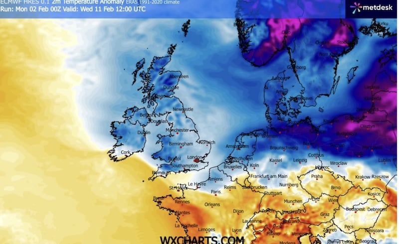 This screen grab from the European Centre for Medium-Range Weather Forecasts (ECMWF) shows a very cold set-up over Ireland on February 11th. The blue colours indicate freezing temperatures.
The National Emergency Coordination Group has issued the following advice
- Monitor Met Éireann forecasts – conditions may change quickly. Visit https://www.met.ie/ for the most up-to-date information. Information is also available across the Met Éireann App, social media platforms (@meteireann) and other news media sources.
- Check local authority websites and social media channels for information on road closures, flooding updates and community alerts.
- Allow for disruption when travelling. Plan extra travel time and reduce speed.
- Expect surface water, debris and poor visibility.
- Do not bypass Road Closed signs – the road ahead is unsafe, the damage may be hidden beneath water and you may be putting your life at risk.
- Do not drive through floodwater – turn back and use another route.
- Check with transport operators when planning journeys.
- Stay back from riverbanks, streams and canals – water levels may rise quickly.
- Keep children and pets away from waterways and flooded areas.
- Keep away from coastal edges, harbours, piers and low-lying promenades during high tide.
- The Irish Coast Guard advice remains: Stay Back, Stay High, Stay Dry.
- Check in with neighbours, older people or anyone who may need assistance in case conditions worsen.
- ESB Networks is highlighting the dangers posed by fallen live wires and is advising the public and the emergency services to stay away from these fallen cables and to report such cases to it immediately. ESB Emergency Services can be contacted at 1800 372 999. The public can monitor www.PowerCheck.ie. in regards to power restoration times.
- Uisce Éireann customers can check the website and social media channels for updates and to get in touch with any issues or concerns via their 24/7 customer care centre at 1800 278 278. The public can also sign up online to their free text alert system to get regular updates about their local supplies – see www.water.ie.
 Taoiseach Micheál Martin has visited areas impacted by Storm Chandra in Wexford, Kilkenny, Carlow and Wicklow. Photograph: Government Information Service
 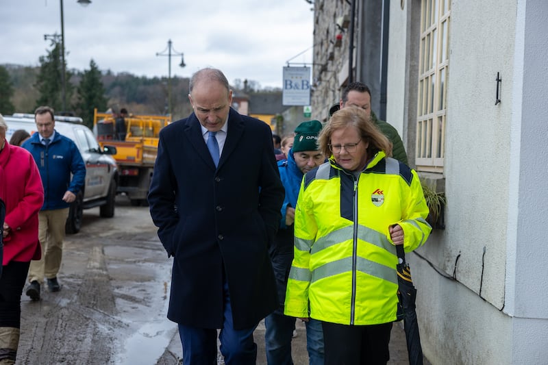 Taoiseach Micheál Martin has visited areas impacted by Storm Chandra in Wexford, Kilkenny, Carlow and Wicklow. Photograph: Government Information Service
Taoiseach promises interim flood defences for Enniscorthy
On Monday, Taoiseach Micheál Martin told sceptical householders and business owners in Enniscorthy, which was badly hit by flooding last week, that interim flood defences will be put in place in the Co Wexford town immediately.
Arriving on Monday at Abbey Quay, which featured submerged cars during the worst of the weather last week, Martin listened intently to Conor Swaine, proprietor of the Btwenty7 coffee shop, who told him the town needed help. His business was flooded, as was his father’s grocery shop across the river on Shannon Quay.
Martin assured Swaine that immediate support would be in place, interim flood defences would arrive and, in the longer term, there would be a permanent defence scheme.
“You can only take him at his word,” said Swaine as the Taoiseach, followed by Minister for Housing James Browne, Minister of State for Infrastructure Kevin Boxer Moran and a posse of about 30 journalists, cameramen, council workers and gardaí moved on up the street.
Outside Holohan’s bar, Martin spoke to owner Niall Holohan.
“I told him I would give him a shovel to start the work now, save him coming back again,” said Holohan.
At a press briefing before Martin went on to tour flooded towns in Kilkenny, Carlow and Wicklow, he said: “the objective is, first of all, to provide humanitarian support to the families and also supports to the businesses that have been impacted.
“Secondly, the OPW will work with the local authority in respect of interim measures to try to protect these houses and this location more generally. And there are interim measures that can be taken to provide that protection and reassurance and we will do that.”
He said a further “substantial, comprehensive scheme” would be submitted for planning permission.
Wet conditions could be replaced by freezing weather and snow
Ronan McGreevy writes: The extremely wet conditions of recent weeks could be replaced by freezing weather and snow by the middle of the month, according to some longer-term predictions.
Much of the weather chaos in the northern hemisphere has been caused by a weaker-than-usual polar vortex this winter. The polar vortex is caused by high-altitude winds that rotate anticlockwise around the North Pole and usually trap extremely cold air in the Arctic region.
This year, the polar vortex has weakened and frigid air has drifted south, causing freezing temperatures across North America and northern Europe.
This has caused a blocking high-pressure area over continental Europe and the jet stream has drifted south of Ireland, dragging up warm air from the Atlantic, resulting in a lot of moisture and the recent heavy rains and flooding.
It is also bringing unprecedented wet weather to Portugal and Spain, with further deluges expected in in the coming days.
Met Éireann climatologist Paul Moore said the latest runs from the advanced weather models show a split in the polar vortex occurring around the middle of the month.
A split occurs when two high-pressure areas push the vortex from either side. In Europe this can cause high-latitude blocking, dragging cold, easterly air over Ireland.
Such a weather set-up led to the infamous Beast from the East in 2018, which was preceded by a split polar vortex.
Yellow rainwarnings in force
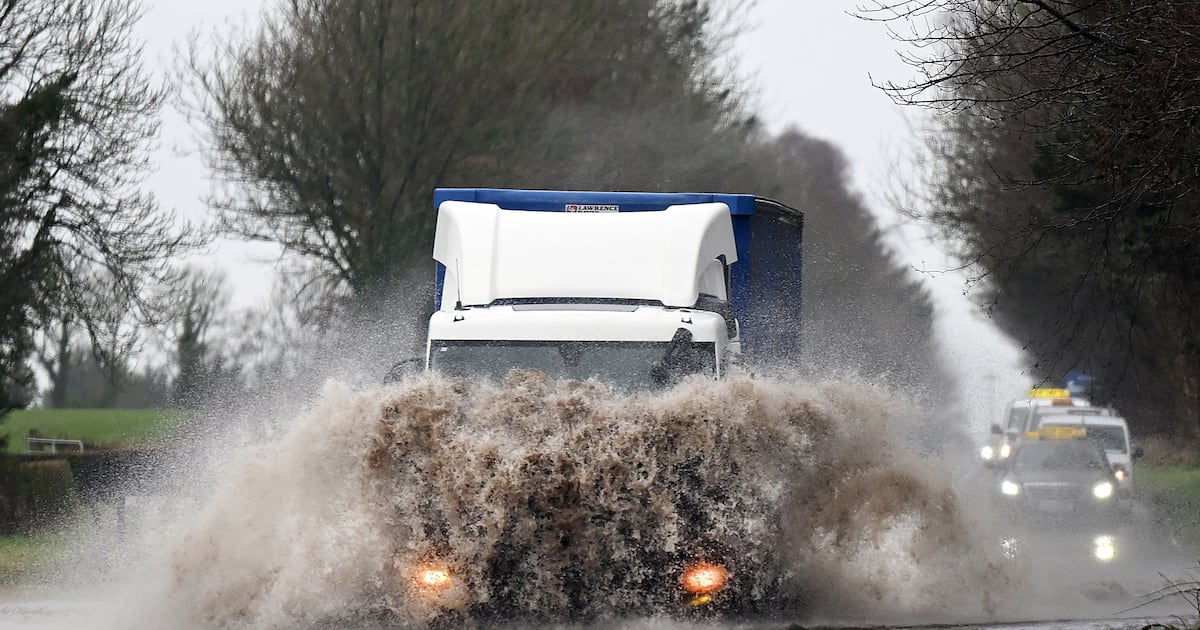
Warnings of heavy rain and possible flooding have been issued for a number of counties in the south and east of the county.
A status yellow rain warning came into effect for Dublin, Louth and Wicklow at 6am on Tuesday. It is due to be in place until 9pm.
Met Éireann issued yellow rain warnings for Carlow, Kilkenny, Wexford, Cork and Waterford from 9am on Monday until 3pm on Tuesday.
It said further heavy rain falling on saturated ground combined with high river levels and high tides will lead to localised flooding, river flooding and difficult travel conditions.
A weather advisory said: “Spells of heavy and persistent rainfall will continue through the week of February 2nd, particularly in southern and eastern coastal counties.
“Rain will fall on saturated ground where river levels are high with high tides expected this week. This will lead to further flooding along rivers and in coastal areas.”