Windchill could bring temps as low as -6C in Ireland
08:06, 31 Dec 2025Updated 08:25, 31 Dec 2025
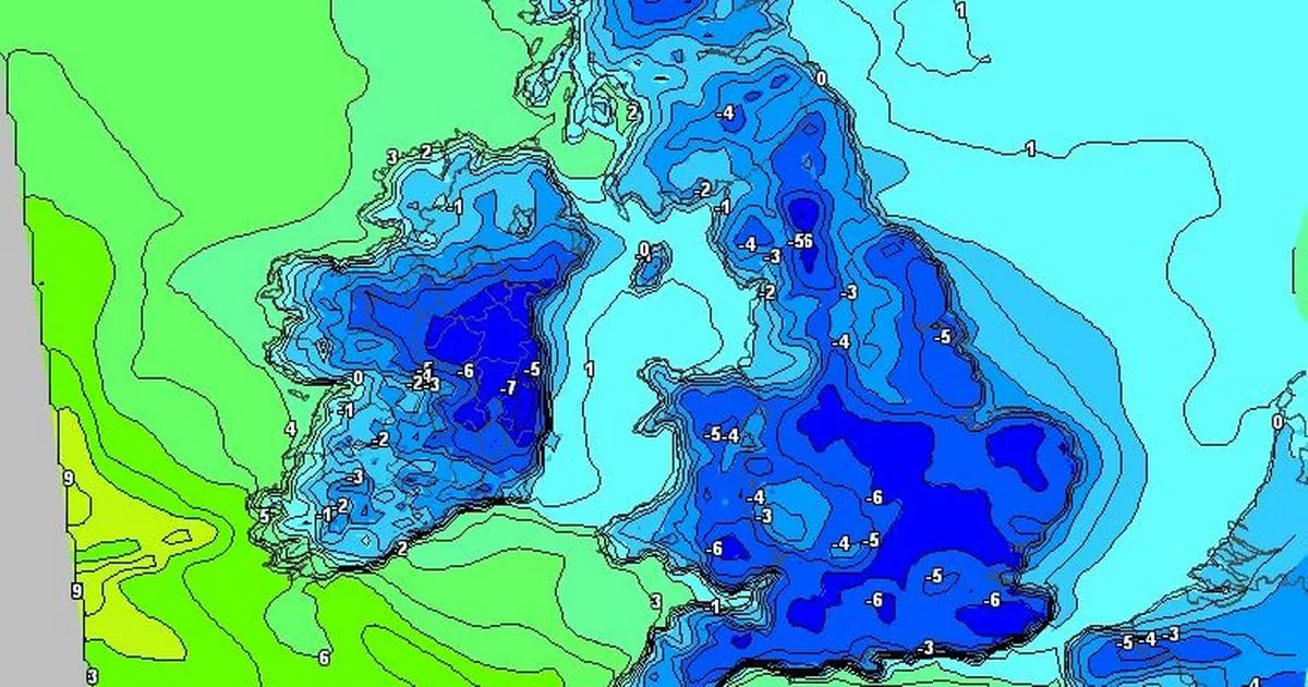
 New Year’s Day – a cold one start (Image: MT)
If you are planning to be outdoors this New Year’s Eve, dig out the thermals or wear about 7 layers as it is going to be bitterly cold tonight – with the windchill factor making it feel as low as -6 in some parts of the country.
Across Cork and Munster, temps will drop below freezing and it will go as low as -2C, with coastal and exposed areas feeling the coldest. However, it will be clear and dry, with light winds and little to no rain for Munster. And 2026 will start off cold and continue in that way, with frost and ice in the mornings, wintry showers and the prospect of some snow should sleet turn more solid over high ground.
It’s also going to be a dramatic start to the New Year for the Canary Islands, a very popular spot for Irish people trying to escape the worst of the cold at this time of year. The Portugese Weather Service has named Storm Francis as the first storm for Europe of 2026.
The forecasters have put yellow alerts in place with warnings of heavy rain and thunderstorms, especially on the southern and western slopes of the western islands:
- La Palma
- La Gomera
- El Hierro
- Tenerife
The good news for anybody heading for Lanzarote this New Year’s eve is that the popular island is expected to be the least affected.
The full forecast for Munster this morning looks like:
TODAY – Wednesday 31st December
Variable cloud and sunny spells today for New Year’s Eve, with any frost clearing early on. Dry for most too, with just the chance of a little drizzle near southern coasts. Highest temperatures of 3 to 6 degrees, with mostly light variable breezes, becoming westerly this evening.
TONIGHT
Dry with clear spells at first, giving way to cloudier conditions and patches of light rain and drizzle moving down from the north overnight. Cold with lowest temperatures of -2 to +1 degrees in light to moderate westerly winds, with frost and icy stretches developing.
TOMORROW – Thursday 1st January
Cloud and any patchy light rain will clear southwards through tomorrow morning, leaving a largely dry New Year’s Day with good sunny spells. Highest temperatures of 4 to 8 degrees in light to moderate northwesterly winds.
National Outlook
Overview: High pressure is continuing to dominate bringing plenty of dry weather overall, though there will be some light rain or showers at times. Turning colder for the weekend with sharp to severe frosts developing and some wintry showers mainly affecting the north and northwest.
Thursday night: Initially dry with clear spells at first. Outbreaks of rain and drizzle will move into the north early on and gradually sink southwards becoming patchier and easing towards morning. Further clear spells and scattered wintry showers will follow from the north. Lowest temperatures of -1 to +3 degrees in light to moderate northwesterly winds.
Friday: A day of good sunny spells, with some showers of sleet and snow possible, mainly in the north. Highest temperatures of 3 to 7 degrees in light to moderate northwesterly winds, fresher near coasts.
Friday night: Continuing mostly dry and clear with some wintry showers, mainly affecting the north and northwest. Lowest temperatures of -2 to +2 degrees in light to moderate northwesterly winds.
Saturday and Sunday: Very cold and mostly dry with wintry showers, mainly in parts of the north and northwest. Highest daytime temperatures of just 2 to 5 degrees in light to moderate northwesterly winds. Lowest night-time temperatures of -3 to +1 degrees with sharp frosts and ice developing.
Further outlook: Continuing cold into early next week, with plenty of dry weather, though there will be wintry showers or outbreaks of rain at times.