
Main points
- Met Éireann have issued rain warnings for 12 counties today. In Dublin, Wicklow and Waterford orange warnings are in effect, while yellow warnings will be in place for Carlow, Cavan, Kildare, Kilkenny, Laois, Louth, Wexford, Monaghan and Tipperary.
- Several rivers including the Liffey, the Nore, the Barrow and the Slaney already have very high water levels and these are expected to rise further on Wednesday and Thursday.
- Wexford County Council says it has been monitoring the tide throughout the night
Sarah Burns – 19 minutes ago
Waterford County Council says it has concerns about road flooding
Gabriel Hines, director of services at Waterford City and County Council, said there are barriers in place at Passage East and Waterford City which are “working effectively”.
“In Dungarvan, in our coastal car parks, some flooding there but we had closed them overnight so we’ve no significant issues there either,” he said.
“Later in the day our difficulty will be similar to Wicklow. We’re going to get significant rainfall, particularly in the Comeragh Mountains. Again, saturated ground, swollen rivers. Again similar to Wicklow, we’re expecting localised spot flooding on our road network.
“We could get some streams overflowing and some river flooding. We would have significant concern in relation to road flooding, in the rivers in particular, feeding off the Comeragh mountains, where we predicted very high intensity rainfall. I think the rivers that are coming from the Comeragh Mountains will be the ones that we could get spot flooding on the local network today.
“Having said that, given the saturated grounds, anywhere we get a high rainfall intensity today, there’s a possibility of the small streams overflowing causing localised spot flooding on the road network. When you’re driving, slow down, expect water on the road network, allow extra time for your journey, extra stopping site distance.”
Sarah Burns – 20 minutes ago
Wicklow County Council says it is preparing for flooding
Michael Flynn, senior engineer with Wicklow County Council, said its crews are all “on alert” and preparing for flooding.
“They’ve been working over the last number of days clearing debris from the last flood event and getting in place measures such as deploying sandbags to areas prone to flooding,” he said.
“We’ve got all our crews ready and available to assist as and where necessary. The areas that traditionally have been prone to flooding have been Aughrim, which had the flooding event last week. Arklow again with the combination of river flooding but we also have high tides and significant onshore winds so the entire coastal regions again we have crews on standby in those locations.
“There’s been very significant damage to our road network, structural damage. So we have road closures in place across the county and we would urge people, if they are making journeys, to check the weather conditions and also check on our social media platforms for notifications of those closures. Above all, we would ask people to heed the warning signs. Those road closures are in place to protect the public from the hazards that exist on those sections.”
Sarah Burns – 36 minutes ago
Dublin City Council monitoring river levels and coastal conditions closely
Dublin City Council said its flood management team is continuing to respond to “ongoing adverse weather conditions and related impacts”.
The local authority is monitoring river levels and coastal conditions closely, to ensure appropriate responses as required, it said.
“Dublin City Council are in regular contact with the National Emergency Coordination Group on all aspects of recent weather events.”
Carparks along coasts at Sandymount and Clontarf remain closed to protect against possible wave overtopping. The cycle lane at Clontarf will remain closed as a precautionary measure.
Eden Quay boardwalk will also remain closed as a precautionary measure. The flood gates along the River Dodder will remain closed until further notice.
“Our crews remain active across the city, making arrangements for possible events and responding to issues as they arise,” it added.
“Crews removal of debris at rivers racks and blockage clearing is ongoing to minimise negative impacts.”
The council said it maintains a limited supply of sandbags at strategic locations for use in response to identified flooding risks.
“These resources are deployed by the council where required, with priority given to critical infrastructure and locations assessed as being at immediate risk.”
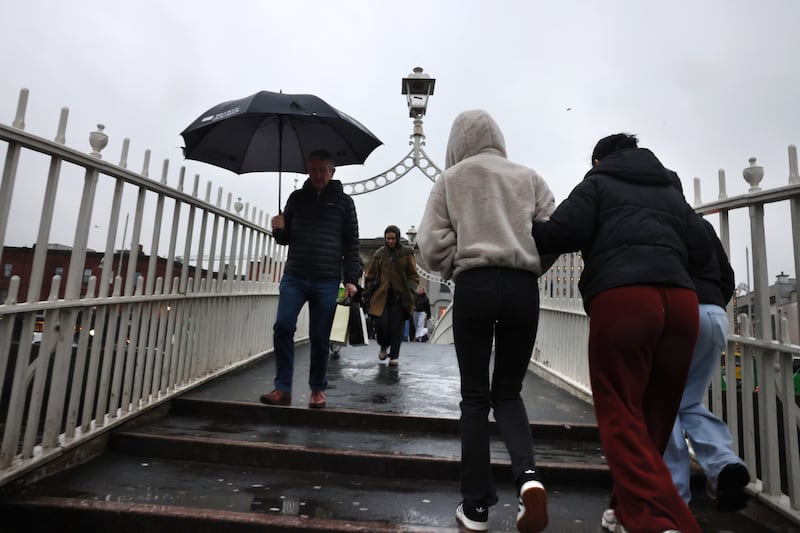 Rain in Dublin City centre on Tuesday.
Photograph: Dara Mac Dónaill / The Irish Times
Sarah Burns – 50 minutes ago
Parts of Dublin will be most at risk of flooding, says forecaster
Weather warnings for Dublin will be yellow from 9am to 12 noon on Thursday after which they will be orange until midday on Friday, senior Met Éireann forecaster Gerry Murphy has said.
“This is because the higher impacts will occur from noon onwards,” he told RTÉ radio’s Morning Ireland, Vivienne Clarke reports.
“Now the reason Dublin has been added in is because with Wicklow it was always considered that there would be very high totals in the mountainous higher levels which would then activate responses in quick responding rivers, which would then have a knock-on effect further at lower levels.
“But it does look like those higher totals are going to extend not only to Wicklow, but also into south Dublin as well. So the higher regions, the Dublin Mountains and parts of Dublin that have flooded recently will also be the most at risk of flooding over the next 24 to 36 hours.
“It’s really the southern half of Dublin that this orange warning refers to simply because the higher ground is in south Dublin in conjunction with the Wicklow Mountains so those impacts that may occur with Wicklow, south Dublin mountains may have a knock-on effect at lower levels over the southern half of Dublin.”
Murphy acknowledged that not all the areas impacted last week will experience the same conditions on Thursday and Friday.
“It may not affect all of them in the same way but nonetheless those are the areas that will be most at risk of flooding and I must say as well people should be aware that this is actually going to be a lot of consistent persistent rain.
“The rain will start off around mid-morning and it’s really going to continue right the way through the rest of today, right the way through tonight and right up until tomorrow afternoon. So it’s going to be very wet really. It may not be raining heavily all of the time but it will be very wet really from mid- morning right the way through to tomorrow afternoon.
“It will be steady rain, sometimes light, sometimes heavy, but at the higher levels in the Wicklow Mountains, Dublin Mountains, where the rainfall amounts will be higher.”
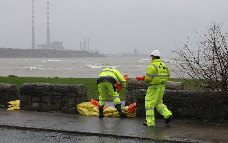 Sandymount strand in South Co Dublin where barriers were erected and sandbags located to combat the high tides on Tuesday and guard against flooding in the area. Photo: Bryan O’Brien / The Irish Times
Sarah Burns – 53 minutes ago
Today will start off mainly dry. Rain developing in the SE early this morning & gradually spreading NW-wards to all areas by mid afternoon, heaviest the SE & E with flooding likely in places. Fresh easterly winds increasing strong to gale force along the E coast.
Highs of 5-10 C pic.twitter.com/ItKGhslS1N— Met Éireann (@MetEireann) February 5, 2026
Wexford County Council says it has been monitoring the tide throughout the night
The chief executive of Wexford County Council, Eddie Taaffe, has spoken of preparations by the local authority for the severe weather warnings for the east coast of the country.
“We’re still about 2½ hours away from a high tide in Wexford harbour,” he told RTÉ’s Morning Ireland, Vivienne Clarke reports.
“We’ve been monitoring the tide throughout the night and the indications are at the moment that while we’ll have a very, very high tide around nine o’clock with a gale force eight, easterly wind pushing it into the harbour.
“I suppose our estimate at this stage is that while we will have limited wave overtopping, that our defences will be able to cope with that.
“We’re optimistic that we won’t have extensive flooding in Wexford Town. So, it’s looking reasonably good at this stage in the harbour.
“River levels in Enniscorthy have dropped steadily over the last number of days, but I suppose we are concerned given the level of rainfall that’s predicted in the Wicklow Mountains over the next 24 hours. So we do remain on alert in Enniscorthy and we have additional temporary defences that we can bring into Enniscorthy and establish quite quickly.”
Mr Taaffe explained that an aqua dam is available, which is “essentially a long, thin balloon that you pump up with water quite quickly and it protects from about a metre of water and they can be put up very quickly along areas that are prone to flooding”.
“So we do have those available to us and we can roll those out quite quickly. We won’t deploy them until later on until we see what happens to the river level in the Slaney over the next 24 to 48 hours,” he added.
 Met Éireann’s Gerry Murphy says rain in the Dublin mountains could have a kock-on effect at lower levels in the south of the city and county. Photograph: Enda O’Dowd ‘It is going to be a very, very wet day,’ says Met Éireann
Senior forecaster with Met Éireann Gerry Murphy has warned Thursday “is going to be a very, very wet day”, with rain continuing to fall until mid-afternoon on Friday.
“This is going to be a lot of consistent, persistent rain” he added, but the rain will arrive more slowly than anticipated, Vivienne Clarke reports.
Speaking on both Newstalk Breakfast and RTÉ radio’s Morning Ireland, Murphy also cautioned that the rain, particularly in the Dublin mountains, is going to have a “knock-on” effect at lower levels in areas such as Shankill and Rathfarnham and other parts of south Co Dublin.
This weather regime is going to continue on Thursday, Friday and over the weekend, with a further band next week, he added.
“Once this rain does get started this morning it’s actually going to continue right the way through the rest of the day overnight and through tomorrow morning as well. So there’s going to be rain where basically it’s just going to continue raining from once it starts mid-morning and then basically it’s just rain, rain until maybe mid-afternoon tomorrow.”
Murphy also pointed out that the timings of the warnings have been pushed back as the rain front is moving more slowly.
“People should check Met.ie for exact timings on the warnings as they all have been pushed back by a few hours,” he said.
Rainfall in the Wicklow Mountains will have the effect of “activating some very responsive rivers and streams in the mountains, which then will have a knock-on effect as it flows down to lower levels. But it does look like those heavier, those more significant high rainfall totals will also encroach into the Dublin mountains and parts of south Dublin.
“Because as has been well documented at this stage the river levels are very high, the tides are high, the ground is saturated so moderate amounts of rainfall can and probably will cause flooding in some places, but this is actually going to be a very wet day.
“Once this rain does get started this morning, it’s actually going to continue right the way through the rest of the day overnight and through tomorrow morning as well. So there’s going to be rain where basically it’s just going to continue raining from once it starts mid-morning and then basically it’s just rain, rain until maybe mid-afternoon tomorrow.
“Then it’s a question of how much damage that causes with regard to flooding of rivers of of local areas, really across the east and southeast of the country, but those look like there will be the highest amounts pushing in over Co Waterford from about 9am that’s why Waterford is in an orange warning as well. As I said, Wicklow and Dublin especially the higher ground but with the knock-on effects to lower levels across Wicklow, and especially the southern half of and then yellow level warnings extending on up then into Louth, Monaghan and Cavan as well.”
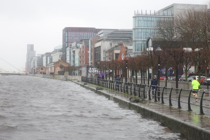
 Braving the rain beside the Liffey in Dublin this week. Photograph: Enda O’Dowd
A number of status orange and yellow rainfall warnings have been issued for counties across the State, with heavy rain and flooding likely in parts, according to Met Éireann.
The national forecaster issued a status orange alert for Waterford, where spells of heavy rain falling on saturated ground, combined with high river levels and tides, will lead to localised flooding, river flooding and difficult travel conditions. That alert is valid from 9am on Thursday for 24 hours.
A second status orange alert affects counties Dublin and Wicklow, where heavy rain is also predicted to cause flooding and difficult travel conditions, is valid from noon on Thursday until noon on Friday. These counties are also under a status yellow weather warning, from 9am on Thursday until noon, when the orange alert begins.
Status yellow rain warnings have been issued for counties Carlow, Kildare, Kilkenny, Laois, Wexford and Tipperary, lasting for 24 hours from 9am on Thursday.
Another status yellow warning, beginning at noon on Thursday, affects counties Cavan, Monaghan and Louth, and is in place until noon on Friday.
Follow irishtimes.com for updates throughout the day.
 Eden Quay in Dublin this week, where high tides and persistent rain led to flood barriers being erected. Photograph: Enda O’Dowd