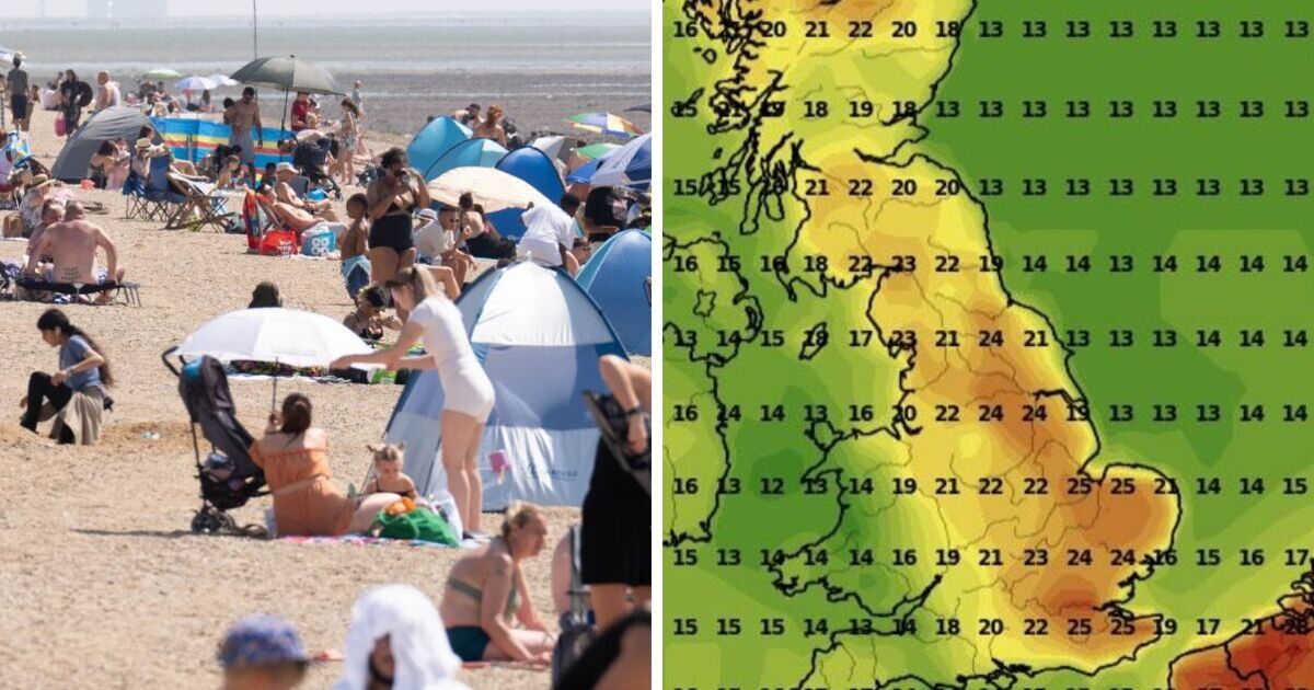
Regions across the UK will sizzle with highs of 25C in just a few weeks’ time. Maps generated by WXCharts on May 25 show the hot and sunny conditions setting in during the second week of June, with parts of southeast England reaching the mid-20s on Monday, June 9. While the warmest weather is forecast for eastern coastal regions, the warm spell will hit most of the country, from the Midlands down to the south coast, in some form, the maps suggest.
Parts of Anglia and Kent, Sussex and Surrey are predicted to experience the hottest temperatures, with the mercury hovering at a more modest 22C in the Midlands and Yorkshire, dropping to between 14C and 17C in Wales, Devon and Cornwall. Northern Scotland is also set for highs of 22C on June 9, the maps suggest, especially around the Highlands, with patches of warmth also forecast for Edinburgh and Glasgow in the southeast.
The burst of hot weather will set in from around midday on June 9, with temperatures holding until the early evening and dropping back to the high teens across the country the following day.
The Met Office‘s long-range forecast for the period warns of “changeable” conditions with southern areas most likely to see dry weather and a decent chance of “hot spells”.
BBC Weather also predicts “a continuation of the drier and warmer weather” on June 9, with the risk of “summer showers or even isolated thunderstorms in some places”.
While it’s comforting to see a possible rise in temperatures on the horizon, parts of the UK will first have to contend with a wet Bank Holiday weekend after forecasts suggested unsettled conditions would end England’s driest spring since 1956 with a band of rain, particularly in northern regions.
“There’s going to be low cloud in places which could produce outbreaks of rain across the Pennines and across higher ground in the south of England, but the main focus will really be northern Scotland,” meteorologist Zoe Hatton said.
“As we go into bank holiday Monday we’re expecting things to stay fairly similar, with showers arriving from the west heaviest and most frequent across the north and west of the country, in Scotland and Northern Ireland,” Ms Hatton said.
“It’s not a complete washout, there will be drier, brighter interludes. It shouldn’t feel particularly cold as we go into the new working week.
“Temperatures are expected to start rising by the end of the week, so perhaps feeling a little bit warmer in the sunshine from Friday onwards.”