
It follows a drizzly start to June which came after one of the warmest and driest Mays since records began The sunshine is making a comeback (Image: Ian Cooper/North Wales Live)
The warm weather is on its way back to Wales as highs of 25°C are expected next week. Met Office weather maps show that sunshine should make an appearance on Wednesday, when the warmest temperatures are expected.
Warm air from the continent will drive temperatures up later this week, but it will bring with it the chance of thunderstorms. It follows a drizzly start to June which came after one of the warmest and driest Mays since records began. According to the weather service Wednesday’s good weather will come after more unsettled conditions on Tuesday.
A plume of warm air moving in from the south will drive a change to the weather later this week.
Highs of 27°C are forecast for Wednesday, 27°C for Thursday with 29°C possible by Friday, the Met Office has said.
Rain and showers across the northern half of the UK will ease through Monday night leaving a drier day on Tuesday, with spells of sunshine across much of the country by afternoon. The south and west will be the cloudiest locations.
But forecasting agency’s forecast for Wales says: “[On Tuesday] often cloudy with outbreaks of light rain and drizzle across the hills and moors. Turning a little brighter during the afternoon.
“Feeling increasingly warm, by day and night. Maximum temperature 19°C.
“Settled on Wednesday with plenty of hazy sunshine.
“Turning cloudier from the south with a risk of thunderstorms overnight. Very warm and remaining changeable for the rest of the week.”
Below are Met Office weather maps showing when and where the best weather will visit Wales on Wednesday.
7am
A cool start to the day with highs of 14°C.
Warmest temperatures around Barmouth and Swansea.
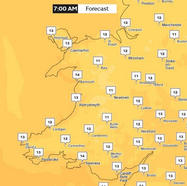 7am on Wednesday(Image: Met Office)10am
The morning will slowly warm up to highs of 19°C in some areas such as Monmouth.
The majority of places will fall around 17°C.
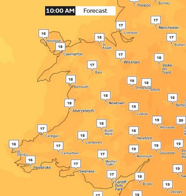 Wednesday at 10am(Image: Met Office)1pm
Things should heat up to highs of 23°C by 1pm.
Some areas around the coast will cooler at around 17°C or 18°C.
However Swansea should be slightly warmer at around 20°C.
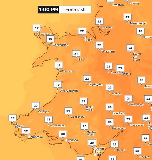 Wednesday at 1pm(Image: Met Office)4pm
Peak temperatures will arrive by 4pm with highs of 25°C – which should come in Wrexham.
Parts of south east Wales should also feel particularly warm by this time.
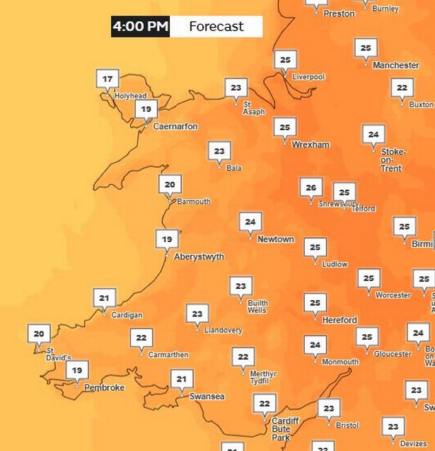 Wednesday at 4pm(Image: Met Office)7pm
Temperatures will remain warm for most of the country before it gradually begins to cool down for the day.
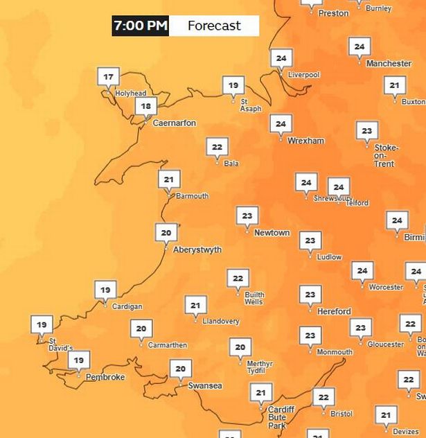 7pm on Wednesday(Image: Met Office)
But thunderstorms are set to move in late on Wednesday. Met Office deputy chief meteorologist, Mike Silverstone, said: “After largely benign weather early in the week, some intense, thundery showers will move in on Wednesday evening. These thunderstorms are being triggered by some warm, humid air that is moving into the UK from the south.
“The intense rainfall could see 20-40mm accumulating over just a few hours, which could cause some disruption. While there are no severe weather warnings issued at the moment, it is possible thunderstorm warnings may be issued this week.”
The thunderstorms and a wider area of showers will move north and east through Thursday, leaving more settled weather for a time through Friday for most. However, another band of thunderstorms moves in again from the south-west later Friday bringing further intense rainfall into the early hours of Saturday.
By the end of the weekend, the humid and thundery airmass will be displaced by fresher and generally more settled conditions spreading east across the UK.
The south is forecast to become more settled with temperatures a little above average while northern parts of the UK, especially the northwest, are likely to be more changeable, with spells of stronger winds, cloud and some rain at times.