Weather forecasters have predicted large parts of England will experience snow later this month Large parts of England could be set for snow according to WX Charts
Spring is officially here and while summer is still a couple of months away, we’ve already enjoyed some sunshine.
In fact, England enjoyed its sunniest March on record this year since records began in 1910, according to the Met Office.
And the start of April looks to follow the same trend by being warm, dry and sunny according to the forecaster.
READ MORE: England set to be hotter than Spain with temperatures entering double figures
Get breaking news on BirminghamLive WhatsApp, click the link to join
However WX Charts is predicting that snow could arrive across most of England in a matter of weeks, potentially bringing a brief end to the sunny weather.
According to wxcharts.com, snow is set to arrive over England at 12pm on Wednesday, April 16, covering parts of northern England and Wales.
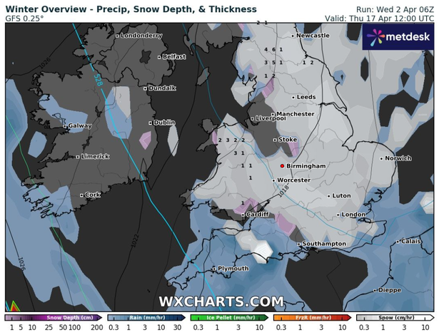 Large parts of England are set for snow, according to WX Charts(Image: WX Charts)
Its set to continue falling over northern England – mainly in Cumbria, Northumberland and Durham – by 6pm that day.
The snow will start to spread south by 12am on Thursday, April 17, according to wxcharts.com.
Up to 4cm per hour could fall over the North Pennines, while there could be a light dusting from Birmingham to Stoke, covering the West Midlands and Staffordshire.
By 12pm on Friday, April 17, large parts of England are set to be blanketed by snow, including much of the Midlands, the north, the east and south east of England, along with Wales.
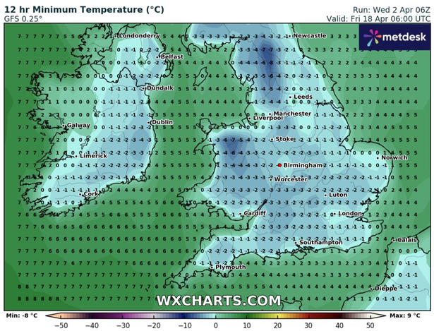 WX Charts has forecasted temperatures to drop below freezing(Image: WX Charts)
A maximum of 6cm per hour could fall over the North Pennines at this time.
While the northwest and southwest of England are set to be spared apart from areas of Dorset.
By 6pm on Friday, April 17, snow is set to remain in patches across the Midlands and south of England, along with the north of England and eastern fringes of England.
And by 6am on Friday, April 18, the snow is set to be confined to the east and northeast of England, with up to 5cm forecasted to land over parts of North Yorkshire.
Meanwhile, at 6amon Friday, April 18, WX Charts has forecasted that temperatures could drop below freezing at that time, particularly in higher regions.
Parts of the North Pennines could see the mercury fall to -8C, while in Snowdonia, the temperature could fall to -7C.
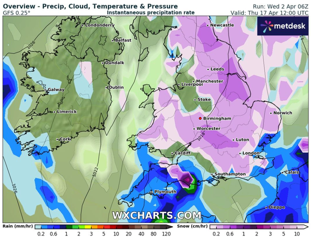 Large parts of England could be set for snow(Image: WX Charts)
Areas around the Midlands could see the temperature fall to -2C at that time.
Meanwhile, in its long range forecast from April 16 to April 30, the Met Office said: “Weather patterns are most likely to remain fairly slow-moving through the second half of April.
“There could be some interludes of rain or showers for a time around mid April, but on the whole plenty of dry and fine weather is expected with high pressure looking to remain in charge for most of the time.
“Temperatures are likely to be around or a little above average overall, and feeling warm inland at times during the day, although some chilly nights are still possible under any clear skies.”