
The UKHSA has issued yellow and amber health alerts starting today as mini heatwave set to hit UK this weekend Yellow and amber health alerts have been issued across the UK this weekend
A second amber heat health alert within a fortnight will come into force on Friday as the mercury is expected to climb above 30C over the weekend.
The alert, covering London, the East Midlands, South East, South West, and East of England, begins at midday on Friday and will remain in place until 6pm on Tuesday.
Simultaneously, the UK Health Security Agency (UKHSA) has issued a yellow warning for Yorkshire and Humber and the West Midlands during this period, warning of significant impacts across health and social care services.
It comes as temperatures could reach 28C on Friday in central and southern England, before rising to 30C on Saturday, then a potential 31C on Sunday, before peaking between 32C and 34C on Monday, the Met Office said.
An amber alert was previously issued for all regions in England on June 19, the first time it had been used since September 2023.
Across Greater Manchester, the temperatures are not quite forecast to reach such heady heights but it’s still expected to a warm weekend, according to the Met Office.
This morning (Friday 27) is expected to be largely cloudy up until mid-afternoon with a chance of rain early on.
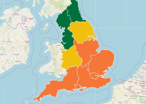 UKHSA amber and yellow alert areas across the UK in place this weekend
Maximum daytime temperature is forecast to be 24C while another warm night is expected, with temperatures of 18C.
It’s a similar picture for Saturday, with cloud expected throughout the morning and into the afternoon with outbreaks of rain and drizzle throughout the day. However, it’s expected to turn brighter later on and into the evening.
Top temperatures are again expected to be around 24C with high humidity levels.
The heat is expected to creep up again on Sunday with highs of around 26C, as the day is set to start overcast, changing to sunny intervals by lunchtime and another warm night expected.
But it’s Monday that temperatures are expected to reach their highest point with a sweltering 31C forecast for the region.
According to the Met Office, strong sunshine is expected through the morning and afternoon, changing partly cloudy by late evening and into the night.
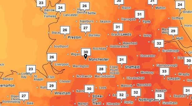 Temperatures forecast around Greater Manchester around 4pm on Monday (June 30)(Image: Met Office)
In the longer forecast, after Monday temperatures are expected to be fresher, around the low 20s carrying into the rest of the week.
Giving the broader picture across the UK as we head into the weekend, Met Office meteorologist Craig Snell said: “From Friday onwards we’re starting to once again see the heat build across England and Wales.
“Scotland and Northern Ireland are going to have a slightly different few days, some parts of western Scotland could see some heavy rain, especially on Friday, and we could potentially see some further rain towards the end of the weekend.
“On Friday, we’re likely to see temperatures potentially peak around 27C or 28C in central and southern parts of England, it’s going to feel quite humid.
“On Saturday, the hottest weather will be in the south east, potentially 30C.
“On Sunday, we’re most likely to see somewhere around 30C or 31C.
“It looks like the peak of the hot spell will be Monday, at the moment it’s looking between 32C and 34C, there’s a chance it’ll be hotter than the previous (heatwave).
“Tuesday, some fresher air is going to spread across the country, but we’re potentially likely to see between 31C and 33C.”
Join the Manchester Evening News WhatsApp group HERE