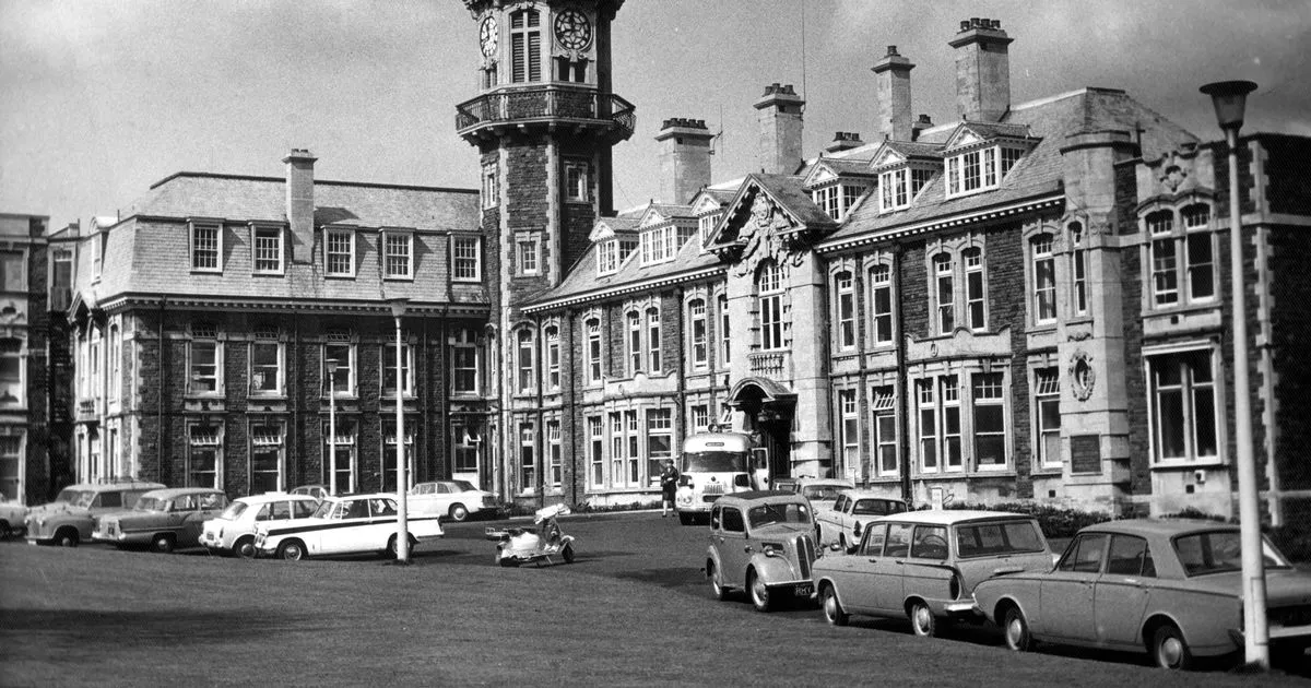
It’s not where you might think, according to topographers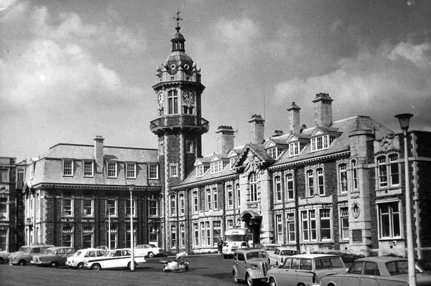 Cossham Hospital, Kingswood. Bristol, pictured in 1965(Image: Mirrorpix)
Bristol is renowned – particularly among people who walk or cycle everywhere – as a particularly hilly city, and of course it’s famous for having the steepest residential street in the country, as well as the spectacular Avon Gorge. That may have more to do with the fact that other cities tend to have historically evolved on rivers with wider flood plains, like London, Manchester, Nottingham, Birmingham and Newcastle, while Bristol’s geography of a steep-sided river valley and gorge is distinctive.
But, out of all those hills around Bristol, which – exactly – is the highest, the biggest, the most above sea level in the city?
It’s a question that, surprisingly, can legitimately have two different answers. Ask anyone born and raised in Bristol, particularly anyone on the east side of the city, and they will instantly know. Most people in Bristol have been brought up with this nugget of knowledge about the city locked into their brains – the highest point in Bristol is Cossham Hospital.
But that, we’re afraid to say, is not strictly true. Or at least, it can be disputed. For there are large swathes of Bristol which are a good 30m to 40m higher than Lodge Hill, the hill on which Cossham Hospital has sat for the past 120 years.
Where is it? And why is there a dispute?
Cossham Memorial Hospital was built between 1905 and 1907. It is still run by the North Bristol NHS Trust, and it was built as a memorial to a man called Handel Cossham. He was a mine owner and local MP with a huge Victorian beard and when he died he instructed that all his collieries be sold off and the money be put to building a big hospital.
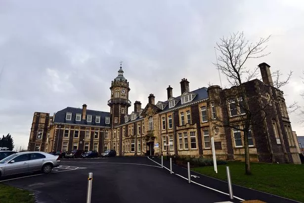 A general view of Cossham Hospital in Bristol.(Image: Dan Regan)
That’s quite a statement, and the hospital was too – it was designed so that its clock tower on the top of Lodge Hill dominated the landscape and would be seen for miles around. It was said that the hospital on Lodge Hill was located on the highest point of Bristol, and that was true.
The top of Lodge Hill where Cossham Hospital is, lies 112 metres above sea level, and with a large hospital building and a tall clock tower, naturally the inhabitants of East Bristol boasted this was the highest point in the city and county of Bristol.
In fact, Lodge Hill continues to rise just a little bit more within Bristol. There is a point on the corner of Clare Road and Tower Road, a stone’s throw from the hospital to the east, which is still just about inside the border between Bristol and what is now South Gloucestershire, which is 115 metres above sea level.
So for generations of Bristolians, Lodge Hill and Cossham Hospital was the answer given to inquisitive school children who asked what the highest point in Bristol was. But then, something happened.
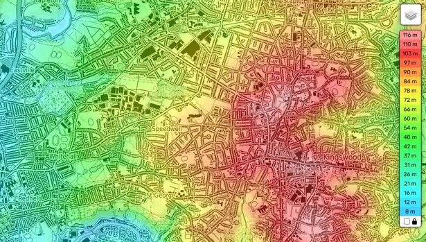 Lodge Hill and Kingswood in east Bristol. The light-pink/white shaded area is the high point of Lodge Hill, close to Cossham Hospital, and rises to 115m above sea level on the Bristol-South Gloucestershire border (Image: topographic-map.com)
In 1949, the city expanded. A deal was done between the County of Bristol and the County of Somerset. Bristol needed to expand and build tens of thousands of new homes to house people displaced or homeless after the Second World War. Bristol wanted to expand its borders east and north into Gloucestershire to take in Filton and Kingswood, and also expand south into Somerset to build the estates of Hartcliffe, Withywood, Hengrove, Whitchurch and Stockwood.
The Government ultimately said ‘no’ to the expansion east – which is we are still left with the anomaly of a lot of ‘east Bristol’ actually being in a different area – but it did say ‘yes’ to the deal with Somerset.
READ MORE: How Bristol traded Portishead Marina for HartcliffeREAD MORE: Bristol ‘needs to move its border’ into Kingswood and Filton to solve city’s housing crisis
Somerset wanted something in return, though. The City and County of Bristol, for centuries up to 1949, also included the coastline and docks at the mouth of the Avon all the way round to Portishead. So in return for moving the Bristol border south from Bedminster Down and Knowle to the bottom of the Dundry Slopes, Bristol gave Portishead Docks – now the Marina – to Somerset.
The new border was drawn to follow the contours of the Dundry Slope – a three-mile long escarpment which rises above South Bristol and forms the horizon for anyone looking south from the city centre. There are four hilltops along the way – in the west, Dundry Hill is the highest, in the middle of the village – which is about 233m above sea-level, then Dundry Down, New Down and finally Maes Knoll Tump, which rises to just about 200m directly south of Whitchurch Lane.
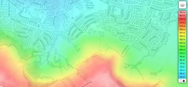 A topographic map of Dundry Slopes and Hartcliffe in South Bristol. The point where the red and orange shade overlaps the Bristol-Somerset border in the centre of the image is the highest point in Bristol at 160m above sea level(Image: topographic-map.com)
The new estates of Withywood, Hartcliffe and then Whitchurch were built up to a point where the slope became too steep – the furthest up the builders went was generally about 90-94m above sea level. But the boundary itself was laid down further up, to follow the old boundary which separated Dundry parish with Bishopsworth parish. And that meant the north-facing slope of Dundry Hill and Maes Knoll were, from 1949, part of the city and county of Bristol.
That generally followed a contour between around 110m and 130m above sea level, but in places, on the northern edge of Maes Knoll Tump, the new Bristol-Somerset border climbs a bit further up the hill.
Topographers and map-makers have worked out the exact point where the border reaches its highest. It’s about ten yards north of the intersection of three fields just a field away from East Dundry Road, directly up the slope and up a track from Hill Farm, overlooking Hartcliffe City Farm.
There, Maes Knoll Tump continues to rise to 199m above sea level, but the Bristol border is 160m above sea level – a whopping 45m higher than Lodge Hill.
READ MORE: Horses, foodbanks and warm welcomes – a straight-talking life on the very edge of BristolREAD MORE: The lost ‘Garden City’ of Bristol – new book reveals how people on one of Britain’s biggest estates were ‘betrayed’
So the geography books had to be rewritten. A point on the Dundry Slopes was now officially recorded as the highest point in Bristol. It’s still not particularly impressive – Bristol’s highest point ranks 43rd out of 48 ceremonial counties’ highest points in England. Only Essex, Cambridgeshire, Suffolk, Norfolk and the City of London have less impressive ‘highest points’.
But the switch did take Bristol out of the relegation zone. If it was still Lodge Hill, Bristol would be below everyone except Norfolk and the City of London.
What’s left for Lodge Hill? Whoever penned it and Cossham Hospital’s Wikipedia page are still claiming records, and here’s the nub of the dispute. Lodge Hill is still recorded as the ‘highest point in urban Bristol’, with the panoramic views of the Dundry Slopes seemingly not counting as part of ‘Bristol proper’ because the houses start further down the bottom.
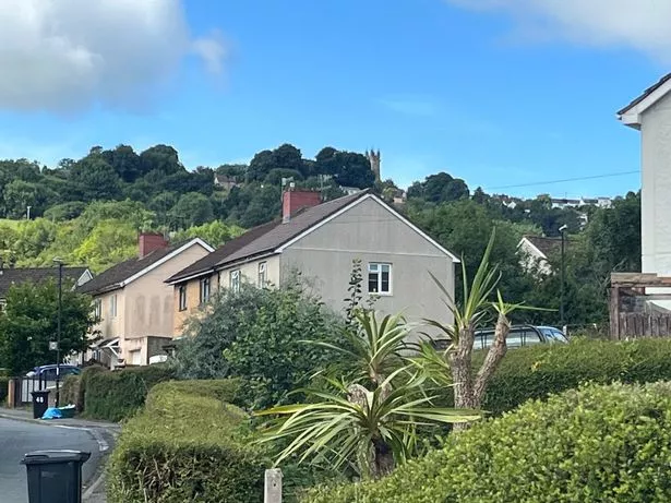 Dundry Slopes, with the North Somerset village and its landmark church tower, dominate the geography of the upper parts of Withywood(Image: Bristol Live)
Even this accolade could be debated, though. Over in the far south west corner of Bristol, in the delights of Withywood, the homes and roads cling to a bowl-shaped extension of the Dundry Slopes. It is a special place – where the city simply stops being urban and immediately becomes rural.
The likes of Chalcroft Walk, Hersey Gardens and The Ridings rise to just about 100m above sea level. But Highridge Road has homes either side of it at the point it crosses the Somerset border into Bristol. And at that point, topographers reckon it’s 117m above sea level – a whole two metres higher than Lodge Hill.