Several parts of Wales could reach ‘heatwave’ threshold towards next weekend Weather map showing how hot it will get on Friday(Image: windy.com)
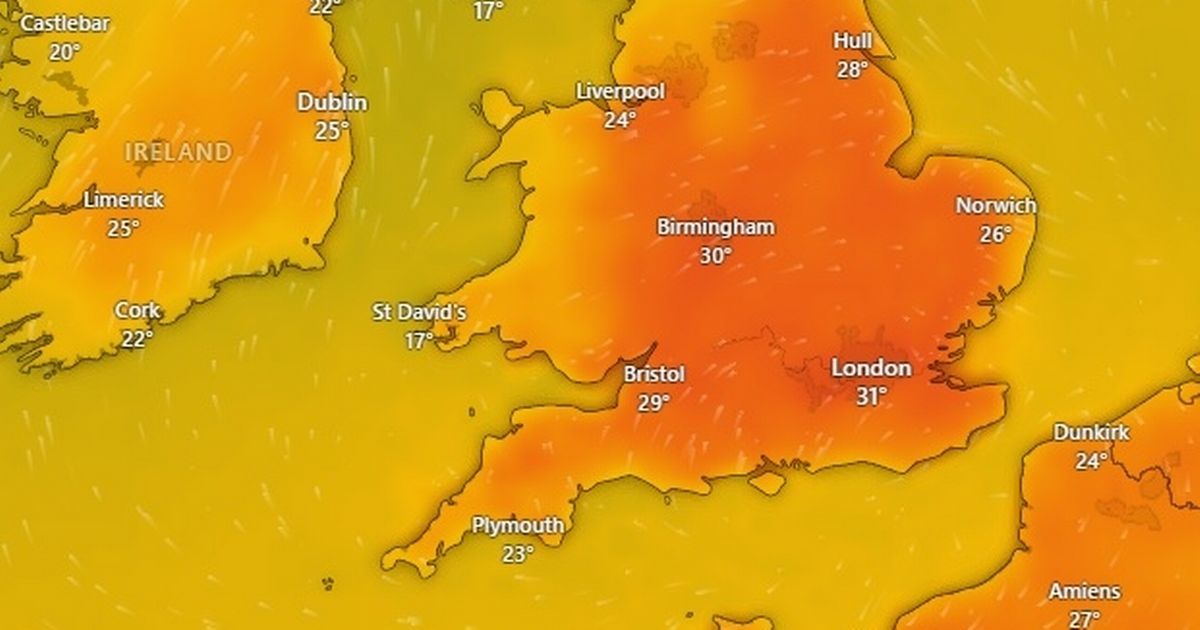
Met Office maps show Wales is set for a significant uptick in temperatures in the coming days – with a heatwave possible by the weekend. Temperatures have been in the low to mid twenties in recent days, with cloudy conditions and some heavy rain in parts of the country.
But temperatures are set to rise significantly in the coming days, with the mercury potentially hitting 29C by Friday. For Wales to have a heatwave, it has to be 25C for three days in a row.
And according to weather maps from the Met Office, there’s several parts of Wales which will hit those temperatures on consecutive days.
On Thursday, weather maps at 4pm show temperatures of 28C in Monmouth, 26C in Newtown, Cardiff and Builth Wells, 25C in Wrexham and Llandovery, and 24C in Swansea and Bala.
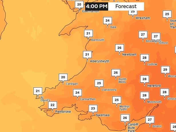 Temperatures at 4pm on Thursday in Wales(Image: Met Office)
On Friday, it will be 29C in Monmouth, 27C in Cardiff, Llandeilo, Builth Wells, Wrexham and Newtown, 26C in Swansea, Carmarthen, Cardigan, and 25C in Pembroke, Bala, Barmouth, Caernarfon and St David’s.
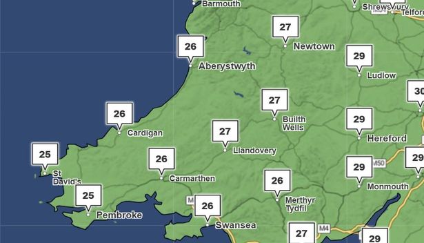 A weather map for Wales on Friday, July 11 at 4pm(Image: Met Office)
On Saturday, it will be 27C in Wrexham, 26C in Newtown, Aberystwyth, Builth Wells, Swansea, Merthyr Tydfil, Cardiff, Carmarthen and Llandovery, and 25C in St Asaph, Caernarfon, Bala and Barmouth and Cardigan.
On Sunday, it is 27C in Monmouth, 25C in Wrexham, Llandovery, Cardiff and Builth Wells. It will fall just short with 24C in Newtown, Aberystwyth, Swansea and Aberystwyth.
Here’s what the Met Office says about the weather between July 7 and July 19.
Monday:
“Apart from an early isolated light shower in the east, the new working week will start fine.
“Though a little breezy, it should feel pleasant in the sunshine that appears. Maximum temperature 20C.”
Tuesday to Thursday:
“A ridge of high pressure will gradually build in from the southwest during the Tuesday to Thursday period. Mainly dry with some clear or sunny spells, and warming up too.”
A long range forecast from Thursday, July 10 to Saturday, July 19:
“A broad northwest/southeast split in the weather looks most likely through much of this period. Towards the northwest, Atlantic frontal systems will bring occasional rain and cloudier skies at times, along with breezier conditions, though there should be some drier, brighter interludes too.
“Further south and east, high pressure will likely dominate with a fair amount of dry and sunny weather to be had. With this, there is a signal for increasing heat and humidity and the potential for another period of hot weather to develop by the second weekend of July, probably lasting into the start of the following week.
“Given the anticipated high temperatures, the chance of thunderstorms also increases, though widespread rainfall across southern areas looks unlikely.”
Get daily breaking news updates on your phone by joining our WhatsApp community here. We occasionally treat members to special offers, promotions and ads from us and our partners. See our Privacy Notice.