Here’s what we can expect over the coming days.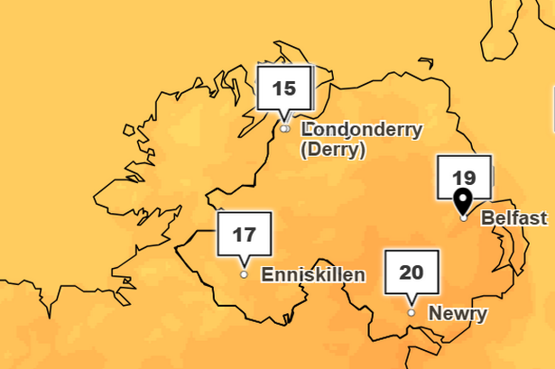 The outlook for Monday(Image: Met Office)
It’s a new working work and there’s some good news on the weather front with sunny spells for the first part of the week before turning sunnier and warmer.
And looking ahead to the end of the week and into next weekend we could see temperatures climbing into the early to mid 20s.
Met Eireann has already signalled that Ireland could experience its first heatwave of the summer as weather models and the latest forecast suggest a prolonged period of hot, dry weather is on the way.
READ MORE: Ireland weather heatwave to last six days as major forecast issuedREAD MORE: Northern Ireland’s ‘most picturesque destinations’ revealed in social media study
The Irish weather service strictly defines a heatwave as “five consecutive days of temperatures above 25C” – and according to the latest weather maps, that threshold could be reached and even exceeded this coming week.
Current models, which are notoriously subject to change, show temperatures starting in the low 20s early in the week before surging higher.
Monday will start off largely dry, bright and breezy with sunshine but turning cloudier through the afternoon with some light showers moving in from the north.
Tuesday will also be mainly dry with sunny spells in eastern areas and cloud building from the west.
Another mostly cloudy start to Wednesday before breaking to leave plenty of sunny spells. Thursday will be relatively cloudy with the chance of the odd spot of light rain or drizzle.
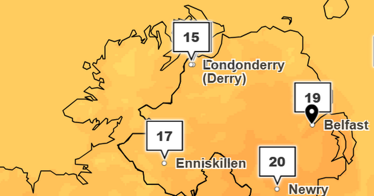
Here’s what we can expect in Belfast over the coming days.
Monday
Mainly dry with bright or sunny periods at first then becoming rather cloudy. A few light afternoon showers possible, mostly towards the North Coast. Maximum temperature 19°C.
Outlook for Tuesday to Thursday:
Ridge of high pressure will bring mostly dry and settled weather with sunny spells. Thicker cloud later Tuesday and into Wednesday with a little rain, especially in the west.
UK long range weather forecast: Friday 11 July – Sunday 20 July
Many parts of the UK are expected to be part way through a period of high temperatures and humidity at the start of this period. The duration, geographical extent and intensity of the heat are all rather uncertain at present, but there is the potential for some very hot weather to be realised, especially across some inland southern and eastern areas.
With this also comes the possibility of thunderstorms, in part because of the high temperatures, but also in association with any frontal systems moving in from the west, which would ultimately usher in cooler and fresher conditions.
Towards the latter part of the period, north-western areas stand a greater chance of experiencing rather more changeable conditions, with drier and occasionally hotter spells more likely further southeast.
 Join Belfast Live Social on TikTok
Belfast Live Social on TikTok will be jam-packed with food reviews, concert announcements, vox-pops of all the important questions and more – giving you handy NI-centric What’s On news at your fingertips.
Be sure to give us a follow HERE and comment the type of content you’d like to see from the team in the future. We are excited to share this side of Belfast life with our new followers.
For all the latest news, visit the Belfast Live homepage here and sign up to our What’s On newsletter.