Issued: 0530hrs Wednesday 16th July 2025
Duty forecaster: Dan Graves
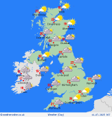 A warm front southwest brings cloud to Ireland and central/south Britain; rain in southern Ireland may be heavy at times.
Good morning,
Upon the passing of yesterday’s low pressure core, cooler air from the north will send showers into north England and southern Scotland, these most common in the afternoon. Decent sun spells will accompany the showers, best of sun and dry conditions in northern Scotland.
A warm front is drifting towards the southwest and will reach southwest England and Ireland later in the morning. Cloud will build across much of Ireland and central/south England, but the main frontal boundary will stall in the southwest. Central and south Ireland will see frequent rain with heavy bursts as the day goes. Southwest England and southern Wales will see rain as well, though more patchy in nature and only isolated heavy spells. High temperatures will reach 20 or 21C for many areas, nearer 23 to 24C central England, up to 26C in the far south.
Little change over Britain overnight with patchy rain in the southwest and clear sky spells to the north. Not so for Ireland: low pressure from the west will begin to encroach brining showery rain, increasingly frequent and heavy. Lows will be 16 or 17C southwest England and Ireland, nearer 11C in the north.
Enjoy your day!
-Dan
Talk live to our forecasters for the latest forecast.
Call 0906 515 1506 (Calls charged at £1.55p/min from within the UK only, network charges may apply, service operated by WCS Ltd WV5 9JD, helpline 01902 895252)