Weather warnings are designed to let people know there’s a potential for impacts in their location
17:14, 20 Jul 2025Updated 17:14, 20 Jul 2025
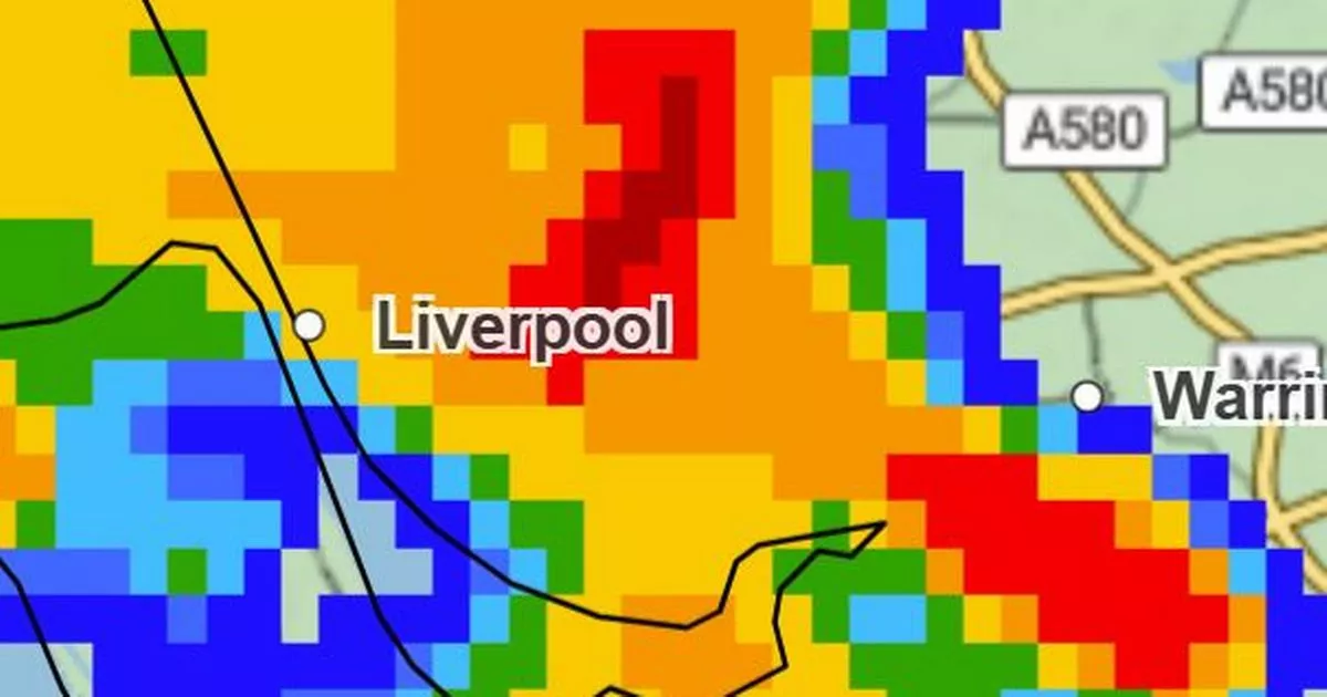
 Met Office map at 5.45pm shows heavy rainfall, July 20(Image: Met Office)
A yellow weather warning for rain is in place across parts of the country, including Liverpool. Other areas impacted are East Midlands, North East, Wales, West Midlands and Yorkshire & Humber. The Met Office says people can expect showery rain, heavy and perhaps thundery. It may cause some localised surface water flooding.
Other areas of the country are still under a yellow weather alert for thunderstorms. Weather warnings are designed to let people know there’s a potential for impacts in their location. This means that any warning we issue should make you think about what steps you can take to minimise the chances of disruption for you.
For yellow warnings, you should check the details of the forecast and consider taking steps to minimise impacts for you and your household. Even in a yellow warning area, people will see disruption to a greater or lesser extent, so the Met Office advises it’s important to check the details and see which steps you could take to prepare.
The new yellow alert for rain has been active since 11am and will remain in place until 10pm this evening. The weather agency has shared further details about the warning, stating: “Showery outbreaks of rain, heavy and perhaps thundery in places, will move northwestwards from late Sunday morning and through the afternoon before gradually easing during the evening.
“Accumulations of 10-20 mm are expected fairly widely, with a few places potentially receiving as much as 40 mm, much of this falling in just a few hours. This could lead to some surface water flooding.” Below is an hour-by-hour weather forecast for this afternoon and this evening, July 20, in Liverpool.
Hour-by-hour forecast Liverpool
- 5pm: 80% chance of rain and 21C
- 6pm: 40C chance of rain and 20C
- 7pm: 50% chance of rain and 20C
- 8pm: 60% chance of rain and 19C
- 9pm: 70% chance of rain and 18C
- 10pm: 60% chance of rain and 17C
- 11pm: 50% chance of rain and 17C
In the Met Office forecast for today, it states: “A cloudy start with showers developing during the day, these turning heavy and perhaps thundery in the afternoon with hail and gusty winds, merging to give longer spells of rain at times. Limited brighter interludes in between and feeling humid. Maximum temperature 23 °C.”
The outlook for Monday, July 21, says: “Bright and dry to begin but showers and longer periods of rain again forming as the day progresses, locally heavy and thundery. Feeling warm in any sunshine. Maximum temperature 24 °C.”
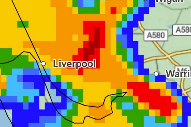
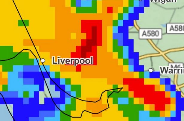
As heavy rain falls across parts of the country, including Liverpool, a Met Office rainfall map has turned red for areas of Liverpool, indicating rainfall of up to 16-32mm/hour in the hours between 5pm and 7pm this evening.
 Met Office map at 5.45pm shows heavy rainfall, July 20(Image: Met Office)
A second weather warning for Monday has also been issued for large areas of the UK, including Liverpool. The thunderstorm warning covers areas of East Midlands, East of England London & South East, North East, North West, South West, West Midlands, Yorkshire & Humber, Scotland and Wales.
The warning will come into place on Monday July 21, at 11am and remain in place until 9pm. the weather agency warns “Heavy showers and thunderstorms may lead to flooding and disruption in a few places on Monday.”
It adds: “Scattered heavy showers and thunderstorms are expected during Monday, especially during the afternoon and early evening. While many will miss the worst conditions, a few places could see 30-50 mm of rain within a couple of hours. Heavy downpours of rain will be the primary hazard but lightning strikes are also likely along with the potential for hail.”