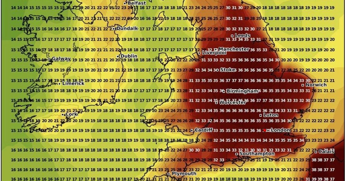
One weather model suggests the mercury will soar in the second week of August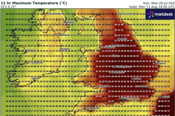 The GFS model suggests that, on Monday, August 11, it will remain very hot in many places, especially in central England(Image: WXCharts)
It has been a mixed start to the summer holidays with spells of sunshine interrupted by showers for most of us. One weather model is suggesting high pressure ridges across the continent could deliver scorching temperatures to Wales and England during the second week of August.
The Global Forest System (GFS) model predicts a heatwave could persist for a week or longer, with temperatures potentially reaching 37°C in some parts of the UK. The projections indicate heat beginning to build from Sunday, August 3, before reaching its peak on Sunday, August 10.
Should this materialise, Monmouthshire might experience highs of 35°C whilst the north Wales coastline could see temperatures hit 31°C.
The GFS prediction suggests the intense heat will then gradually retreat from west Wales on Monday, August 11 with border counties still experiencing highs of 31°C-33°C, with a blistering 37°C possible across central England.
Sweltering conditions from Spain and Portugal are presently being blocked by low pressure systems caught within the jet stream.
An Azores high is edging towards southwest Britain, establishing a north-south weather divide anticipated to persist as the dominant pattern through early August – with rainfall further north and more stable conditions in the south.
However, by the second week of August, the Azores high might break free from its constraints, reports North Wales Live.
Netweather meteorologist Ian Simpson wrote over the weekend: “Longer range outputs from the GFS model indicate that, from there, it won’t take much to get some of that hot weather in Spain and Portugal spreading back northwards through western Europe, should one of those ridges of high pressure head eastwards into central Europe.
“This is a long way off, and substantial heat through Britain and France looks unlikely for at least another 10 days.”
Nevertheless, the Global Forest System (GFS) suggests warmth beginning to develop next weekend, from Sunday, August 3.
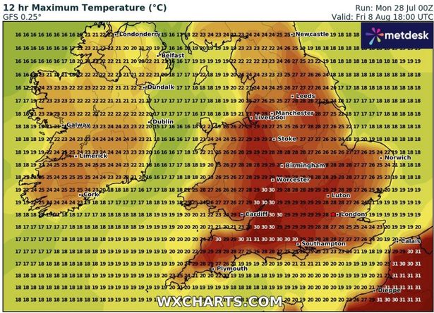 By Friday, August 8, the heat plume is predicted to have reached most of Wales(Image: WXCharts)
Predictions at this distance carry considerable uncertainty and models don’t all concur.
For instance, another forecaster ECM implies that any surge of warmth across Britain might fail to penetrate Wales and northern England. Love dreamy Welsh homes? Sign up to our newsletter here
What the Met Office says
The Met Office indicates there are “hints of a more settled August”, with “tentative signs of a more settled spell developing” early in the month.
“Some models are hinting at a Scandinavian high building to the north of the UK, which could bring drier and warmer conditions,” it stated. “However, confidence remains low at this range.”
The Met Office says that from August 2-11, high pressure to the southwest of the UK will maintain drier weather across the southern half of the UK.
They state: “Perhaps turning widely settled later into August where high pressure to the southwest extends more bodily across the country.
“Temperatures around or a little above normal, perhaps warming further up later in the month.”
Their long range forecast for the rest of August says high pressure, and therefore more settled conditions overall, appears most likely.
“For most, dry weather is likely to continue, although short periods of showers and thunderstorms cannot be ruled out,” they say.
“Temperatures are most likely to be around to above average, with a near normal chance of brief spells of hot weather.”
Get daily breaking news updates on your phone by joining our WhatsApp community here. We occasionally treat members to special offers, promotions and ads from us and our partners. See our Privacy Notice