Temperatures are set to rise again (Image: WXCharts)
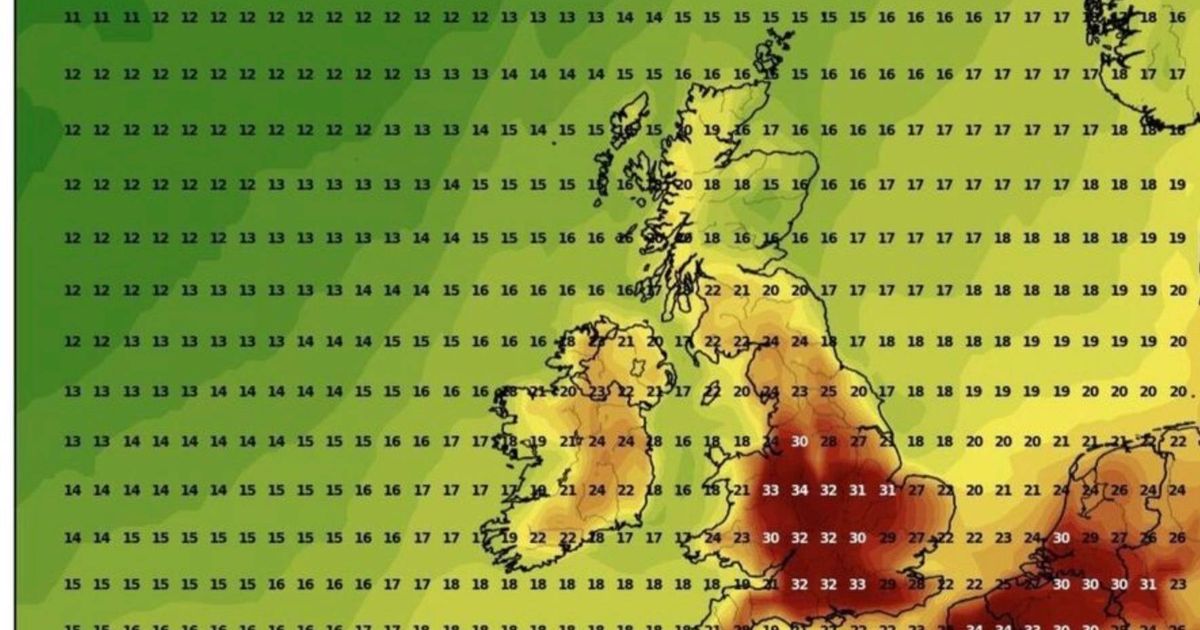
The UK is about to experience another heatwave, with temperatures being forecast to reach 37C.
The mercury is expected to climb again further into August following several weeks of rain, cooler weather, and thunderstorms, turning weather maps a darker shade of red.
The arrival of the new hot spell is being forecast for around Saturday 16 August, hitting Gloucestershire, Warwickshire, Worcestershire and North Wales the hardest, according to maps from WXCharts using MetDesk data.
These areas could see temperatures soar to 37C, potentially the highest temperature recorded in Britain since the notorious 2022 heatwave, which saw a record-breaking high of 40C.
Oxfordshire, Berkshire and Hampshire won’t be far behind, with highs of 36C forecasted.
Meanwhile, all of southern England is set to experience sizzling temperatures of 35C, with south Wales also expected to peak at 35C.

Major cities in the South West, including Bristol and Bath, will see the temperatures rise to 33C, while west and mid Wales will have slightly cooler temperatures of 32C, reports the Mirror.
The east and west Midlands are set to record highs between 33C and 36C, while parts of Yorkshire and the Humber are likely to hit 33C. Scotland and Northern Ireland will be noticeably cooler, reaching highs in the low to mid 20s.
Kent, London and Surrey will also experience the heat, with temperatures forecast to rise to 34C, while coastal areas including Brighton and Portsmouth are being forecast to have 33C.
This is the Met Office forecast for the South West for the coming week
Headline
Turning windy with outbreaks of rain on Monday.
This Evening and Tonight
Any patchy rain easing with clear spells for a time. Cloud thickening from the west with outbreaks of rain in the far west of Cornwall by dawn and becoming increasingly windy, especially along northern coasts. Minimum temperature 14 °C.
Monday
Storm Floris, brings unseasonably windy conditions on Monday with outbreaks of heavy rain spreading east through the day. Drier through late afternoon with sunny spells, though still windy. Maximum temperature 22 °C.
Outlook for Tuesday to Thursday
A bright and breezy day on Tuesday with the odd isolated shower, but drier and warmer on Wednesday with lighter winds. Cloudier again on Thursday with scattered showers.