Tropical Storm Erin forms in the eastern tropical Atlantic
BREAKING NEWS. BREAKING RIGHT NOW AT NOON. TROPICAL STORM AARON HAS FORMED IN THE ATLANTIC. THANK YOU FOR JOINING US. I’M TIFFANY KENNEY. AND I’M AARON GUY. THE NATIONAL HURRICANE CENTER IS PREDICTING THIS COULD BE A MAJOR HURRICANE. LET’S BRING IN FIRST WARNING. METEOROLOGIST SANDRA SHAW. SHE HAS THE LATEST ADVISORY. SANDRA. ALL RIGHT, WELL, AARON DROPPED AT 11 A.M. AND BASICALLY, AS WE HAD BEEN PREDICTING ALL WEEKEND LONG AND ALL THIS MORNING, IT HAD A VERY GOOD CHANCE OF DEVELOPING. AND NOW IT HAS 45 MILE AN HOUR SUSTAINED WINDS AND IS REALLY RACING TO THE WEST NOW AT 20 MILES AN HOUR. SO IT’S EAST OF THE CABO, WEST OF THE CABO VERDE ISLANDS, CLOSE TO AFRICA AND MAKING ITS WAY, KIND OF DIPPING SOUTH OVER ATLANTIC WATERS AND THEN MAGNIFYING AND INTENSIFYING INTO A HURRICANE BY PERHAPS WEDNESDAY. AFTER THAT, IT CONTINUES THAT WESTWARD JAUNT. AND THEN IT’S LOCATED NORTHEAST OF PUERTO RICO AND INTO THE CARIBBEAN AS A MAJOR CATEGORY THREE HURRICANE WITH 115 MILE AN HOUR WINDS. FOR THE LATEST NHC ADVISORY. THE GOOD NEWS IS, MOST OF THE MODELS NOW WANT TO SHIFT IT MORE TO THE NORTH AFTER THAT, BUT IT IS WAY TOO EARLY TO CALL. AS YOU KNOW FROM FALLING THE TROPICS DOWN HERE, HERE’S A LOOK AT ONE OF THE MODELS. THIS IS THE AMERICAN MODEL. I’M GOING TO SHOW YOU BOTH THE AMERICAN AND THE EUROPEAN. AS YOU CAN SEE, IT MAKES GOOD HEADWAY. IT INTENSIFIES, IT BECOMES LARGER. THE EYE MORE PRONOUNCED. BUT THEN LOOK, IT GETS THAT LITTLE SHOVE THANKS TO HIGH PRESSURE ANCHORED OFF OUR EASTERN SHORE AND A FRONT TO OUR NORTH TO MOVE AWAY FROM THE US. THE EUROPEAN MODEL HERE ON SUNDAY HAS IT WELL TO THE EAST
WPBF 25 First Warning Meteorologist
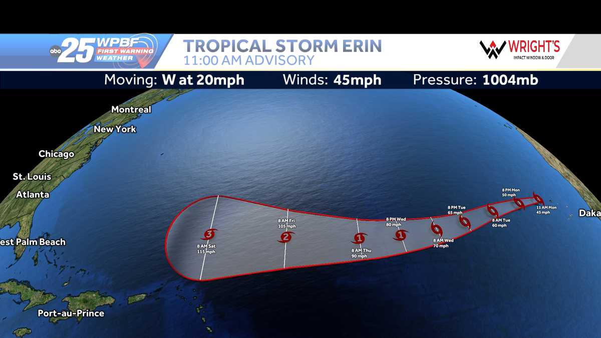
Tropical Storm Erin formed Monday morning in the eastern tropical Atlantic Ocean. This is the 5th named storm of the 2025 Hurricane Season. As of the 11 a.m. advisory, Erin was located about 280 miles west-northwest of the Cabo Verde Islands and about 2,305 miles east of the northern Leeward Islands.It was moving west at 20 mph with 45 mph maximum sustained winds. Tropical Storm Erin can strengthen into the first hurricane of the season. The WPBF 2025 Hurricane Season ForecastPreparing your emergency kit for hurricane seasonHurricane Preparedness Week: Understanding forecast information Interactive radar: South Florida weather coverage from WPBF 25 NewsGet the latest weather updates with the WPBF 25 News app. You can download it here.
Tropical Storm Erin formed Monday morning in the eastern tropical Atlantic Ocean.
This is the 5th named storm of the 2025 Hurricane Season.
As of the 11 a.m. advisory, Erin was located about 280 miles west-northwest of the Cabo Verde Islands and about 2,305 miles east of the northern Leeward Islands.
It was moving west at 20 mph with 45 mph maximum sustained winds.
Tropical Storm Erin can strengthen into the first hurricane of the season.
Preparing your emergency kit for hurricane season
Hurricane Preparedness Week: Understanding forecast information
Interactive radar: South Florida weather coverage from WPBF 25 News
Get the latest weather updates with the WPBF 25 News app. You can download it here.