Tropical Storm Erin forecast to become a hurricane in next few days over central tropical Atlantic
THANK YOU FOR JOINING US HERE AT 11:00. FIRST WARNING, METEOROLOGIST BROOKE SILVERING. JOINING ME NOW WITH THE LATEST ON TROPICAL STORM ERIN AND BROOKE. THE NEW ADVISORY JUST CAME IN AT 11:00. THAT’S RIGHT. MOMENTS AGO IT IS STILL MOVING WEST. I EARLIER WAS AT 22MPH. NOW IT’S SLOWED DOWN TO 20MPH. WINDS SUSTAINED AT 45MPH. SO STILL TROPICAL STORM STATUS. AND IT WILL CONTINUE TO DRIFT OFF TOWARDS THE WEST AS WE GET CLOSER TO THE END OF THE WORKWEEK. THEN WE’LL SEE THIS STRENGTHENING INTO A CATEGORY ONE HURRICANE AS EARLY AS FRIDAY. AND THEN FROM THERE, RAPIDLY INTENSIFYING INTO A CATEGORY TWO WINDS PICKING UP TO 100MPH. JUST STAYING TO THE NORTHEAST OF THE LESSER ANTILLES ISLANDS AND THEN STAYING WELL TO THE NORTH THERE OF THE CARIBBEAN ISLANDS. AS WE GET CLOSER TO YOUR WEEKEND, SATURDAY NIGHT INTO SUNDAY MORNING FOR THE STRENGTHENING INTO A MAJOR HURRICANE, MEANING CATEGORY THREE THERE. EVENTUALLY, THOUGH, A LOT OF MODELS ARE IN AGREEMENT THAT IT’S GOING TO MAKE A CURVE AS WE HEAD INTO THE SECOND HALF OF THE WEEKEND AND INTO THE START OF THE NEXT WORKWEEK THERE. NO IMPACTS DIRECTLY FOR THE STATE OF FLORIDA, ALTHOUGH IT COULD INCREASE THE RIP CURRENT RISK ACROSS AREA BEACHES. SO AS WE TAKE A LOOK AGAIN, YOU HAVE TROPICAL STORM ERIN OUT INTO THE ATLANTIC. WE HAVE ONE AREA THAT WE’RE NOT TOO CONCERNED WITH DEVELOPMENT. ANOTHER SPOT, THOUGH, THAT COULD SEE FURTHER DEVELOPMENT IS IN THE WESTERN GULF. BUT FOR NOW, THOUGH, WE ARE MONITORING THE WESTERN CARIBBEAN AS WE HEAD INTO THE NEXT COUPLE OF DAYS, WE’LL SEE THIS AREA OF DISORGANIZED SYSTEM THAT DISORGANIZED STORMS DRIFTING OVER THE YUCATAN AND THEN ENTERING INTO A MORE FAVORABLE SPOT FOR FURTHER DEVELOPMENT, SOMETHING WE’RE GOING TO BE WATCHING OUT FOR, FOR MEXICO AND EVEN SOUTHERN TEXAS. NO IMPACTS FOR US HERE DIRECTLY ACROSS THE STATE OF FLORIDA. A CLASSIC SEA BREEZE FOR TODAY. RAIN AND STORMS MAINLY STILL ALONG THE WESTERN HALF OF THE STATE AS WE HEAD THROUGHOUT THE REST OF THE NIGHT. TONIGHT, LOOKING QUIET AS WE HEAD INTO YOUR MORNING TOMORROW, THOUGH, IT’S GOING TO BE OFF TO A VERY WARM START. LOOK FOR THE UPPER 70S LOW 80S AND THEN REACHING THE UPPER 80S FEELING LIKE THE MID 90S. AS EARLY AS 11 A.M. ANOT
Tropical Storm Erin forecast to become a hurricane in next few days over central tropical Atlantic

Updated: 11:21 PM EDT Aug 12, 2025
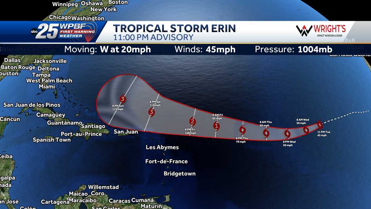
Tropical Storm Erin formed Monday morning in the eastern tropical Atlantic Ocean. This is the fifth named storm of the 2025 hurricane season. As of the 11 p.m. advisory, Erin was located about 2,440 miles east of the northern Leeward Islands.It was moving west at 20 mph with 45 mph maximum sustained winds. Erin is expected to strengthen into the first hurricane of the season this week. The WPBF 2025 Hurricane Season ForecastPreparing your emergency kit for hurricane seasonHurricane Preparedness Week: Understanding forecast information Interactive radar: South Florida weather coverage from WPBF 25 NewsGet the latest weather updates with the WPBF 25 News app. You can download it here.
Tropical Storm Erin formed Monday morning in the eastern tropical Atlantic Ocean.
This is the fifth named storm of the 2025 hurricane season.
As of the 11 p.m. advisory, Erin was located about 2,440 miles east of the northern Leeward Islands.
It was moving west at 20 mph with 45 mph maximum sustained winds.
Erin is expected to strengthen into the first hurricane of the season this week.

Preparing your emergency kit for hurricane season
Hurricane Preparedness Week: Understanding forecast information
Interactive radar: South Florida weather coverage from WPBF 25 News
Get the latest weather updates with the WPBF 25 News app. You can download it here.