
Weather maps have turned red in 17 counties of England where temperatures could reach 32C Temperatures could rise in a matter of days(Image: Ben Birchall/PA Wire)
As we approach the end of August, the temperature is starting to feel cooler and more like Autumn.
After enduring a sizzling summer with four heatwaves, it feels like the best of the hot weather is behind us.
But according to weather forecasters, that may not be the case.
READ MORE: Exact date 765-mile storm to end heatwave misery as maps show deluge
Get breaking news on BirminghamLive WhatsApp, click the link to join
Weather maps from WX Charts reveal that a mini-heatwave could arrive next week, bringing with it highs of 32C.
The hot weather is concentrated around parts of the East Midlands, East Anglia and South East of England.
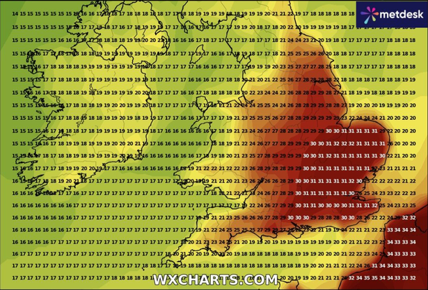 The temperature could reach 32C in England(Image: WX Charts )
A total of 17 counties in these parts of the country have turned red, with temperatures set to range between 30C and 32C.
Although the charts haven’t forecast the conditions for a true heatwave, where temperatures must reach 25C for three consecutive days or more, they reveal that we could experience a mini heatwave.
In its long-range forecast from August 26 to September 4, the Met Office said: “Majority of this period comes with lower than average confidence, even accounting for the long range.
“This is due to large uncertainties surrounding the behaviour of ex-hurricane Erin at the beginning of the forecast and its subsequent impact on the large scale weather pattern over the UK.
“Probably beginning fine for the vast majority of areas, but a band of rain, already in or threatening the west, is likely to move slowly east, perhaps preceded by showers in the south.
“More changeable weather is likely thereafter, possibly even at times unsettled, with more in the way of rain, showers and stronger winds than recently.
“Starting off warm, especially in the south and east, but temperatures are likely to dip nearer to average for most of the rest of the period.”