A map shows the potential impact of rising sea levels threatening many coastal areas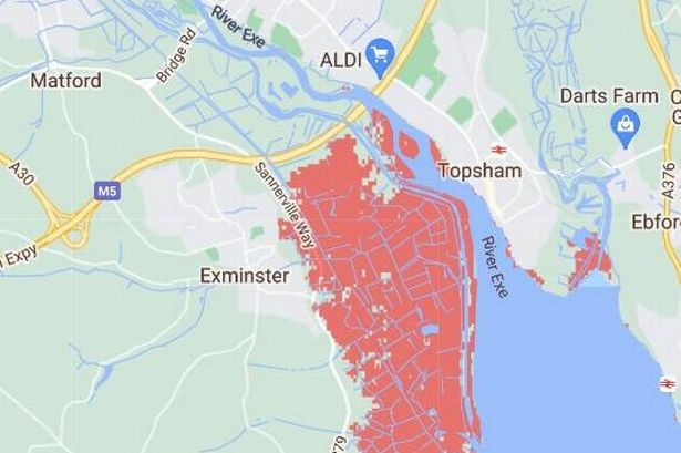 The areas in red could be underwater by 2050(Image: Climate Central)
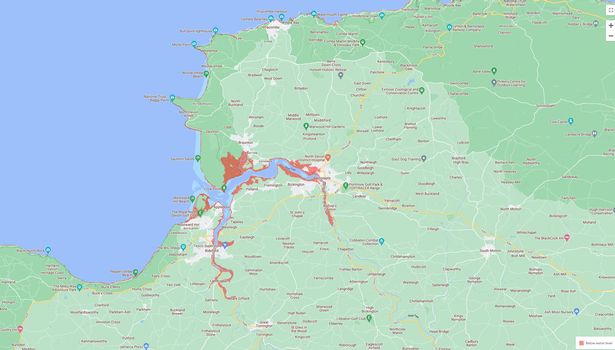
Exminster, Barnstaple and several coastal towns along Devon’s north and south coasts could be partially submerged by 2050, according to a map developed by Climate Central.
The map illustrates the potential impact of rising sea levels threatening many UK coastal areas.
It suggests that some of Devon’s most popular beaches and towns could be inundated due to the effects of climate change on sea levels.
A previous report by MPs found that melting ice caps could put up to 1.5 million UK properties at an increased risk of flooding by 2080 due to rising seas caused by melting Arctic ice.
In addition to more extreme weather, melting ice caps will endanger many coastal communities. It is startling to see how many locations could be impacted.
Some UK holiday towns could be affected as early as 2050, with their beaches gradually disappearing underwater.
Climate Central’s map is based on peer-reviewed scientific research published in leading journals.
Not only does the map highlight the vulnerability of much of the UK coastline to rising sea levels, but it also indicates that even more land will be at high risk of severe flooding.
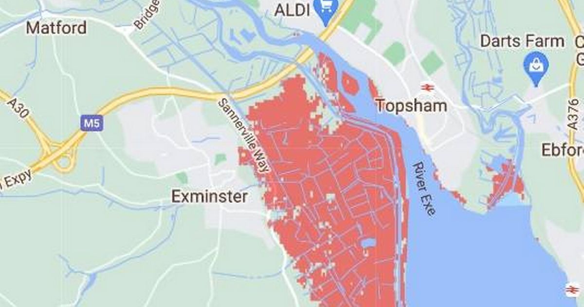
The area in Devon most at risk is Exminster, with large parts of the village just south of Exeter marked in red.
Every bit of land from the River Exe up to the A379 is forecasted to be submerged within the next three decades.
 Areas of Devon could be at risk(Image: No credit)
Topsham, located on the opposite side of the Exe, is also predicted to be affected, albeit not to the same catastrophic extent.
On the North Devon coastline, Barnstaple and neighbouring seaside towns, including Appledore, Bideford and Baunton, could witness large swathes of land disappearing beneath the waves. In Barnstaple, the town’s Asda Superstore is just one area that could be lost by 2050.
It remains unclear whether future planned defence works were considered when the data was published.
Elsewhere in the UK, the east England coastline from Hull, within the Humber Estuary, running south is potentially the most severely impacted region. This encompasses the Lincolnshire coast round to Norfolk, including King’s Lynn, and extends alarmingly far inland towards Peterborough and Cambridge.
Several areas along the southeast England coast are also set to be affected. From Portsmouth to Bognor Regis, Shoreham-by-Sea, and a large area around Rye.
Just around the coastal bend, the Isle of Sheppey could seemingly be halved in size, with even parts of central London being affected by the rising sea levels. Then Foulness Island and the Bengie National Nature Reserve are also set to lose some land to the sea.
At a previous Flood and Coast Conference in Telford, Sir James Bevan, chief executive of the Environment Agency (EA), warned of the irreversible damage caused by coastal erosion and rising sea levels, stating: “While we can come back safely and build back better after most river flooding, there is no coming back for land that coastal erosion has taken away or which a rising sea level has put permanently or frequently under water.”
The idyllic Welsh village of Fairbourne confronts the stark reality of complete submersion, with local authorities forecasting it will become unliveable by the mid-21st century. Officials plan for residents to evacuate, allowing the area to revert to its natural marshland state.
As Arctic regions experience temperature increases four times greater than the worldwide average, both wildlife and human populations face significant threats, potentially affecting UK weather systems – though further research remains necessary to establish concrete links.
Additionally, escalating meltwater from Greenland poses a serious threat to the North Atlantic’s Atlantic meridional overturning circulation (Amoc), a crucial ocean current that regulates Britain’s climate. If the Amoc were to fail due to alterations in oceanic salinity and temperature, Britain could experience significantly harsher winters, whilst tropical regions might witness rapid warming.
Multiple scientists forecast this occurrence could happen within the coming 100 years. James Gray, Chair of the polar research sub-committee, has previously warned: “For too long the effects of a changing Arctic have been out of sight, out of mind. Before melting glaciers and ice sheets contribute to widespread flooding and irreversible weather patterns in the UK, we must throw our full toolbox at understanding changes in the Arctic better.
“We must prioritise and put more funding behind scientific and multi-disciplinary research. At the moment, Arctic science is concentrated on its summer, with the Arctic winter which could tell us an enormous amount about the weather being under-studied.
“More collaboration is needed among UK universities to avoid repetition of scientific endeavours seeking out the same information, and with our international partners to learn and share resource.”
In response to these concerns, a Government spokesperson said: “The UK holds a prominent position in global Arctic research, ranking among the top four nations in peer-reviewed Arctic research output, while allocating approximately £10 million annually for Arctic science projects.
“The UK is a committed observer to the Arctic Council and we stand ready to increase our participation further. Additionally, we are investing £5.2 billion in the UK’s flood defences by 2027 to enhance protection for hundreds of thousands of properties both now and in the future.”