Monday, 1 September 2025, 13:15
September will start with weather instability in Spain. The entry of a trough on Sunday from the northwest will bring «very strong storms» to the country at the beginning of this week, the state meteorological agency (Aemet) has announced. The effects of this front will be felt in the extreme north and northeast of the Spanish mainland.
Over the next few days, a succession of fronts will bring heavy rain and storms that will particularly affect Catalonia and the Balearic Islands, although it will also leave precipitation in Galicia and the whole of the Cantabrian area.
The drop in temperatures that we have experienced over the last few days will continue this Monday, with a drop in temperatures across most of the country. However, between Tuesday and Wednesday the values will rise again and will be above 34C in some provinces in the southern half of the country.
“Very heavy” rain and thunderstorms in these areas
The trough that brought unstable weather to the north of the Peninsula on Sunday will finish crossing the eastern Mediterranean area today, according to Aemet. The “Atlantic circulation” will put three regions on alert for rain and storms: Aragon, Balearic Islands and Catalonia.
Specifically, the storms will be «very strong and with hail» in the Pyrenees and eastern Catalonia in the first half of the day and, in the afternoon, “locally strong” in the eastern Balearic Islands. Late in the day they could affect the Valencian coast. Precipitation may also occur in Galicia and surrounding areas, extending to the Cantabrian Sea, where very strong gusts of wind are expected.

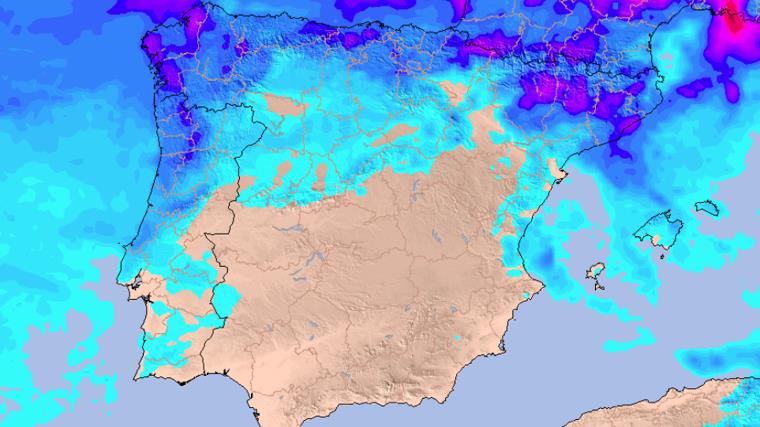
Precipitation map for Wednesday.
Meteored

Aemet warns of the entry of a new weather front on Tuesday, which will leave «precipitation spreading from west to east across Galicia and surrounding areas», especially persistent in the Rías Baixas. There will also be showers and isolated thunderstorms in Catalonia, Valencia and the Balearic Islands.
The instability will not give any respite in northern Spain, as the entry of another trough on Wednesday from the extreme northwest will bring precipitation that “will spread from west to east” and that, in the afternoon, may be accompanied by thunderstorms. Wind gusts will be very strong in Galicia and Asturias.
Changing temperatures
The passage of the trough will leave a widespread drop in temperatures this Monday on the mainland in Spain and in the Balearic Islands. The drops will be «noticeable» in large inland areas of the eastern half of the country with very cool values for this time of year. The exception will be the southeast coasts and the south of the Balearic Islands, where they will increase.
Between Tuesday and Wednesday, there will be increases in temperatures across practically all of Spain, “locally noticeable in the northern plateau”. Temperatures will only fall in the Mediterranean area.
Therefore, they could reach over 34C in some provinces such as Murcia, Seville, Granada, Bilbao and Badajoz. As for minimum temperatures, they will not fall below 20 degrees in most of the Mediterranean area. On Thursday the mercury will drop again.
