
Wednesday, 10 September 2025, 15:30
The meteorological summer we have just left behind us in Spain was, together with the summer of 2022, the warmest since at least 1961. Between 3 and 18 August, coinciding with the heat wave, temperatures were up to 6C above normal. This extremely warm environment has contributed to heating up the Mediterranean, specifically the area between Alicante, Gerona and Mallorca (the Balearic Sea), a worrying factor that may favour torrential rains this autumn.
At this point in time, nobody forgets the violent ‘Dana’ storm of 29 October in Valencia, which occurred when the sea temperature was warmer than normal. And this summer the surface temperature of the water along the Mediterranean coast has even exceeded that of the air. On 1 July in the Murcian municipality of Los Alcázares, on the shores of the Mar Menor, the air temperature was 28C, while the water was 28.3C; and on 17 August the average temperature in the Balearic Sea reached 28.6C. On the same day on the beach of Valencia it reached 29C.
29C
When the Mediterranean is “hot”
“The sea is warmer”, was a common phrase heard amongst bathers this summer. As confirmed by the state meteorological agency (Aemet), the temperature of the Mediterranean sea in some coastal areas (such as Valencia) reached 29C on some days in August. And in places like Los Alcázares, in Murcia, there was a day when the air temperature was 28C, while the water was 28.3C. In other words, it was warmer in the sea than out.
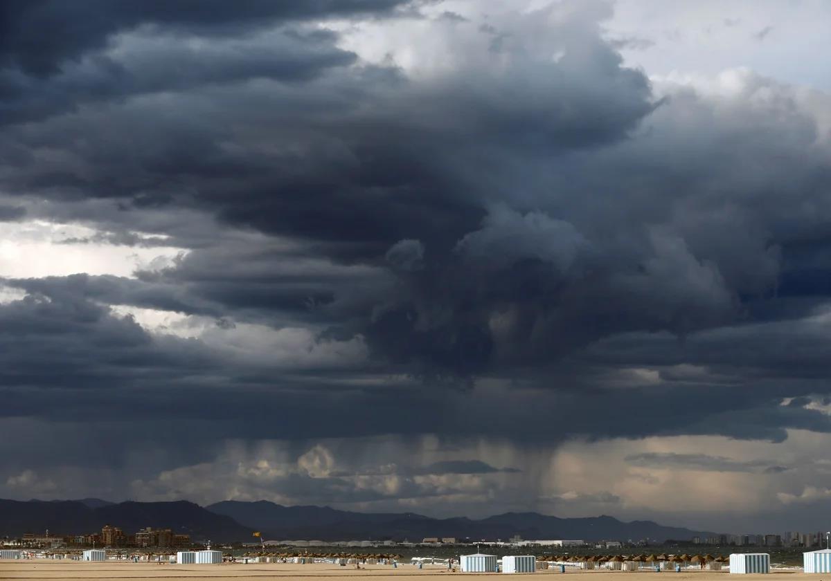
Experts argue that this heat at the sea surface is “fuel” for extreme weather events, such as danas. Rising sea temperatures act as an enhancer of these storms and make them more damaging by priming them with energy. The process is as follows: warm water evaporates more easily and the air becomes more humid and warmer. Thus, when it collides with cooler layers of the atmosphere, conditions are created that are conducive to the formation of such sudden and intense storms as a ‘Dana’.
Jorge Olcina, professor of regional geographical analysis at the University of Alicante, where he teaches land use planning, climatology and natural hazards, said that the warming of the Mediterranean “is nothing new”, and that year after year “the trend of temperatures above 27 or 28C at the beginning of September is once again repeated”.
Energy reservoir
All studies indicate that the Mediterranean is one of the world’s sea basins that has warmed the most in the last 40 years (1.5C since 1980), “twice as much as the air over this sea”. Therefore, Olcina points out, “it is becoming a reservoir of energy, especially in the summer and autumn months”. The professor highlighted the sea’s capacity to retain the heat absorbed. “It holds the temperature much better than the air itself.”
And a warm Mediterranean, he said, is a sea that is “very potentially unstable, that transfers a lot of energy to the atmosphere, which causes very energetic clouds to form, heavily laden with water that discharge large quantities of water in a short time”. “The fact that the Mediterranean is so warm increases the amount of water and above all the intensity,” said Olcina, an expert who was a reviewer of the fifth report of the IPCC, the UN-linked group of experts that updates knowledge on climate change.
The professor from Alicante is not so much concerned about 300mm of rainfall, but about 150mm falling in an hour. “That is what spells disaster because it generates sudden flooding of rivers and ravines, and there is practically no room for manoeuvre to be able to act,” he explains. For this reason, he believes that this situation requires extreme vigilance of atmospheric conditions, “as Aemet is already doing perfectly”, and above all to inform the population “immediately” if there is a red warning for torrential rains. “We cannot lose one more human life over this issue,” he added.
Olcina pointed out that although it will be a complicated autumn, “at this stage we don’t know if there will be a dana or not. What we do know is that we have the basic factor, which is the water in the Mediterranean, which is why atmospheric vigilance must be extreme,” he said.
Necessary but not sufficient
José Ángel Núñez, head of climatology at Aemet in the Valencian community, explained that the autumn torrential rains are atmospheric phenomena that are fed by the energy accumulated in the sea, “but an excessively warm sea is not necessary, because these episodes do not occur in mid-August, when the sea is normally warmer, but from mid-September and above all, in October and November, when the sea is already cooling, around 21C”.
To trigger such violent storms “you need a suitable atmospheric configuration”. “If this occurs, the importance of the temperature of the sea will be relative to the mass of air that flies over it, that is, to the difference in temperature between the air and the sea (the greater the difference, the greater the instability). But if the right atmospheric situation does not occur, the sea by itself is not capable of generating torrential rains,” said Núñez.
As of today, with only the temperature of the sea water, “we cannot say whether or not there will be torrential rains in the Mediterranean communities, as we do not know if the favourable atmospheric configuration will occur”. In other years, the meteorologist explained, a warm summer sea has been followed by a dry autumn with the accumulated energy dissipating progressively as the season progressed.
Núñez, a geographer and climatologist, saia that until the short term, “seven to ten days before the phenomenon”, it is not possible to anticipate whether or not the cold drop will occur. Even so, it is not advisable to lower one’s guard. In fact, the rapid attribution studies carried out on the dana of 29 October indicated that this phenomena “is now 12 per cent more intense and twice as likely”, because “the availability of energy and humidity is greater now with a very warm Mediterranean”, he explained.
“With more energy, we have seen that phenomena such as those of 29 October are more likely and more violent, but the truth is that we cannot say today whether or not there will be an episode of torrential rains in the Mediterranean communities,” the climatologist added.