Brits hoping to bask in balmy spring temperatures can instead expect to wake up to heavy downpours forecast to last an entire day – with no region spared and major cities hit A ‘Beast from Europe’ storm is set to interrupt warm weather next month (stock)(Image: PA)
A ‘Beast from Europe’ storm looks set to batter Britain next month and bring an onslaught of unpleasant weather that will ruin a “very warm” May, new weather maps reveal.
According to the GFS weather model, no region will be spared when the horror downpour lands on May 8 from midnight onwards. People in England, Wales, Scotland and Northern Ireland hoping to bask in balmy spring temperatures can instead expect to wake up to heavy showers forecast to last all day. It comes as the Met Office warned of “periods of wetter and more unsettled conditions” arriving in the second week of May, and possibly developing into “locally heavy showers and thunderstorms.”
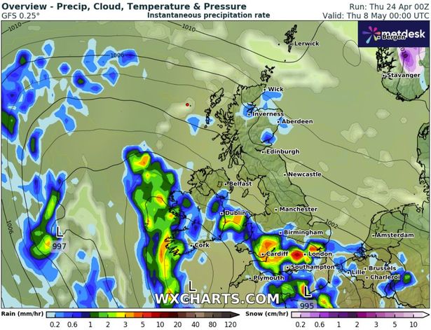 The storm is set to land on Thursday, May 8, from midnight(Image: WX Charts)
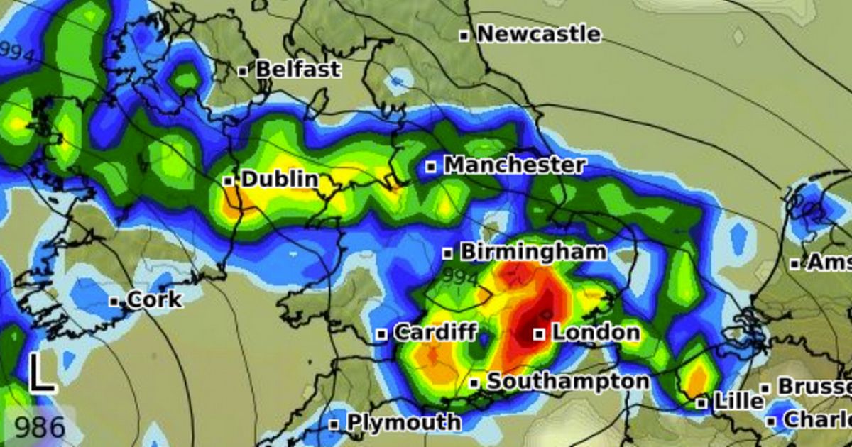
The storm is first expected to land in the south and parts of Scotland during the early hours of May 8 before spreading countrywide as the day progresses. Exeter, Southampton, Cambridge, Ipswich and Birmingham are among the areas set for a soaking on Thursday morning. In Scotland, rain will hit Wick, Inverness, Aberdeen and areas north of Edinburgh, according to the maps.
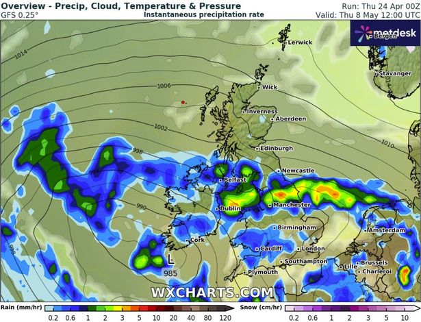
By 6am, rain will clear in Scotland but intensify across the Midlands and the north. A number of major cities including Cardiff, Plymouth, Birmingham, Manchester – and a large chunk of Norfolk – will welcome rain during the early morning rush hour.
By noon, showers will cover the bottom half of Wales including Cardiff, Newcastle, Manchester, Liverpool and a small area of Dumfries and Galloway in south-west Scotland a. During this time, temperatures will range between 6C and 15C.
 Major cities, including Cardiff, Birmingham and Manchester will be hit(Image: WX Charts)
The rain is set to interrupt “very warm” temperatures enjoyed in the days prior. According to the Met Office’s forecast for April 28 to May 7 – before the storm lands – the month will be “most likely starting off widely fine with sunny spells, following the clearance of early morning mist and fog.”
This will most likely be seen in the south, while in the north there will be a greater chance of more cloud which may take some time to clear. Fine and “very warm” weather could extend right across the country during this period, with the chance of cloud or rain in the northwest sinking southeast and introducing more changeable and cooler conditions for a time mid-week.
 The rain is set to interrupt “very warm” temperatures(Image: WX Charts)
From May 8 onwards, the forecaster predicts: “A typical mixture of drier and settled periods, and periods of wetter and more unsettled conditions, is on balance slightly more likely than predominantly unsettled or predominantly settled.
“Temperatures are likely to be around average overall, with a slightly increased chance of warm or hot spells. Any such spells could be accompanied by locally heavy showers and thunderstorms.”