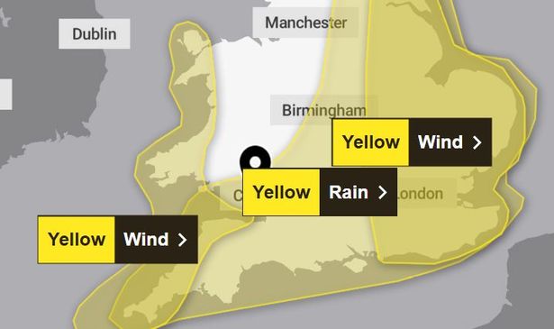
A second warning for wind has also been issued, with the Met Office warning that gusts could reach 60pm
10:57, 21 Oct 2025Updated 12:11, 21 Oct 2025
 A Met Office weather warning comes into force on Thursday for Wales(Image: Met Office)
The Met Office has issued a yellow weather warning as it warns that “extensive and heavy rain” will hit the UK this week. The warning is due to come into force across 12 parts of Wales at midnight on Thursday.
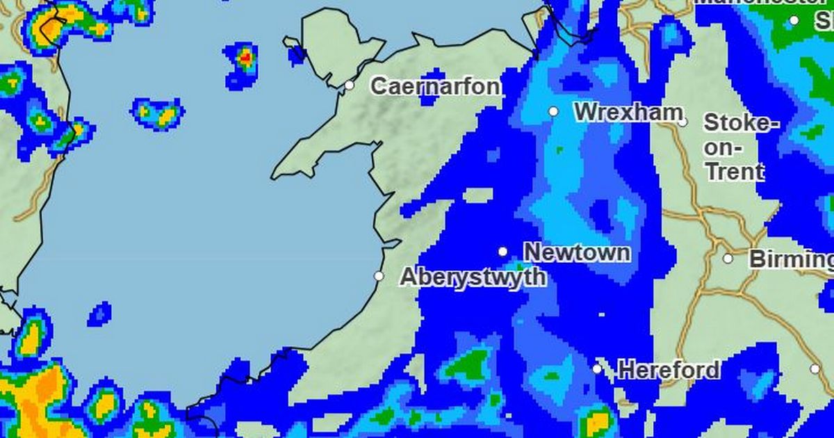
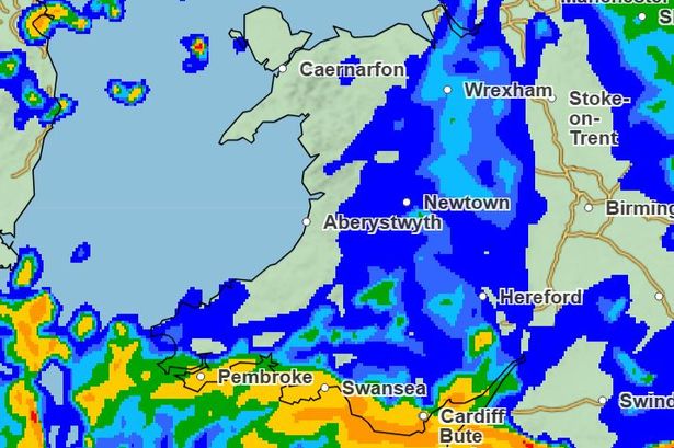
Forecasters have also issued a yellow wind warning seven parts of Wales. The warnings, which will be in place for much of Thursday, state that affected regions should prepare for “substantial rainfall” and “hazardous gusts”. The weather agency warn that is is likely that 20-30mm of rain will fall per hour on Thursday morning, with levels reaching 30-50mm in some areas.
The full list of areas affected by the rain warning in place from midnight until 9pm on Thursday is: Blaenau Gwent, Bridgend, Caerphilly, Cardiff, Merthyr Tydfil, Monmouthshire, Neath Port Talbot, Newport, Rhondda Cynon Taf, Swansea, Torfaen, and the Vale of Glamorgan. For the biggest stories in Wales first, sign up to our daily newsletter here
The wind alert covers Carmarthenshire, Ceredigion, Conwy, Gwynedd, Isle of Anglesey, Pembrokeshire and Swansea from 4am until 6pm.
 Multiple weather warnings have been issued(Image: Met Office )
The rain warning states: “A complex area of low pressure over the mid-Atlantic early this week is expected to move towards the UK whilst deepening, but confidence in the details of its track and intensity as it crosses the UK remains fairly low.
“Despite these uncertainties, there is at least a medium likelihood that an extensive, and in places heavy swathe of rain will move into southwestern Britain during Wednesday evening and spread quickly northeast, with totals by early Thursday morning of widely 20-30mm, and for some places 30-50mm.
“There is a small chance a few places could exceed this, most likely over North Devon and Cornwall and more generally in the east of the highlighted area.
“In association with the rain, conditions are expected to turn windy with a chance of gales, initially along southern and eastern coasts, but more widely across southern Britain during Thursday daytime.”
The Met Office wind warning says: “A spell of strong northwesterly winds will develop across parts of southwest England and western Wales on Thursday.
“Gusts are expected to reach 40-45 mph widely across the warning area, with a risk of these reaching 50-60 mph along exposed coasts and headlands.”
The forecast states that spray and flooding on roads is likely, leading to difficult driving conditions and an increased chance of accidents.
Public transport could also be affected in places with some journey times taking longer. Flooding of a few homes and businesses is “likely.”
For coastal regions, the weather agency warn that large waves are likely and that there is a chance power could be lost.
The Met Office has also said Wales will feel colder from Friday – just in time for October half term.
They said: “Largely dry on Wednesday but heavy rain arriving overnight. Unsettled on Thursday with showers or longer spells of rain and strong winds. Becoming drier on Friday and turning colder.”
Get daily breaking news updates on your phone by joining our WhatsApp community here. We occasionally treat members to special offers, promotions and ads from us and our partners. See our Privacy Notice