“This would destroy the very character of the village”
14:33, 21 Oct 2025Updated 15:47, 21 Oct 2025
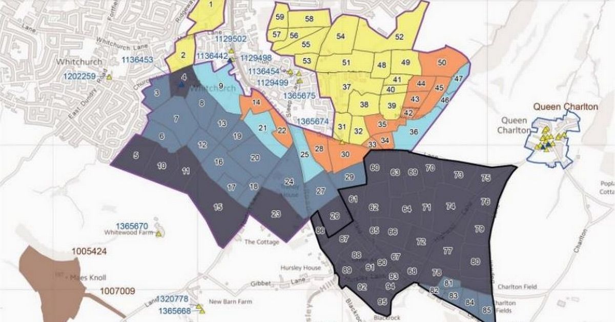
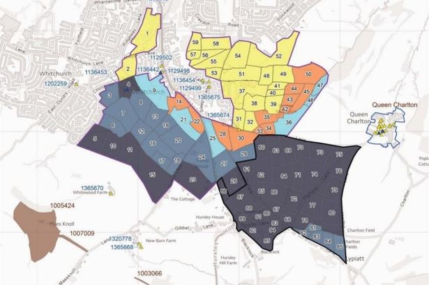 A Bath & North East Somerset map outlining the development possibilities for land surrounding Whitchurch Village, on the edge of Bristol – field by field. The yellow fields are ones which the council planners say would have a low impact on the Green Belt and the surrounding ‘heritage assets’, then orange and light blue, with dark blue having the most impact.(Image: Bath and North East Somerset Council)
People living in a village right on the edge of Bristol are expected to pack into a public meeting tonight (Tuesday, October 21) to discuss their response to new plans which would effectively join them to the city. Bath and North East Somerset Council has published a new draft of its long-term plan for housebuilding, and included options which residents say could see as many as 5,000 new homes built around Whitchurch Village, on the A37 out of South Bristol.
The new B&NES local plans document outlines how huge amounts of new housing development will have to take place on green belt land, and tells residents that the Labour bovernment has brought new policies in that could allow that in the future, especially on what it describes as ‘low quality’ green belt land known as ‘grey belt’.
In the entire Bristol to Bath corridor, which takes in Whitchurch, Hicks Gate on the edge of Brislington, Keynsham and Saltford, the council’s draft plan has a range of locations and a range of options which, if all new homes are built that are suggested, would see a total of 12,630 built – or given planning permission – in the next 10 years.
The bulk of those are around Keynsham and Whitchurch. In Whitchurch Village residents have been campaigning against large-scale development in the fields around their village – and postponed plans for a ring road connecting the A4 with South Bristol. They are back renewing their campaign with an initial meeting tonight.
The council’s draft local plan, which lists four options or locations for large-scale development in Whitchurch, also includes an assessment of what the impact, or ‘risk ratings’ would be of building on the green sites – field by field.
A map in the draft plan shows that the green spaces between Whitchurch Village and Whitchurch to the north west, and Stockwood to the north east of the village are the ‘lowest risk’, while fields to the south are the highest.
READ MORE: New South Bristol suburb – first look at 500-home developmentREAD MORE: 1,000-home expansion in Bristol suburb branded ‘what the city needs’
But the planners who drew up the draft local plan pointed out that building up to 2,000 new homes on the land to the south east of Whitchurch would be such a big development that it would also bring ‘sufficient public benefits’ that could outweigh the ‘harm’ of building on the countryside there.
“Land on the south east edge of Bristol and in the transport corridor linking Bath and Bristol lies within the green belt,” the B&NES document said. “Strategically this is an important part of the green belt in separating the two cities and the settlements that lie in between. The physical separation of not only Whitchurch village from Bristol, but also Keynsham from Bristol, and Keynsham and Saltford village are of great importance to the respective communities.
“In considering locations for development the need to retain, strengthen and enhance green infrastructure corridors is crucial. Land can only be released from the Green Belt for development through a local plan and only if justified by ‘exceptional circumstances’,” it added.
 Around 300 residents attended a meeting with Marvin Rees about the South Bristol ring road proposal
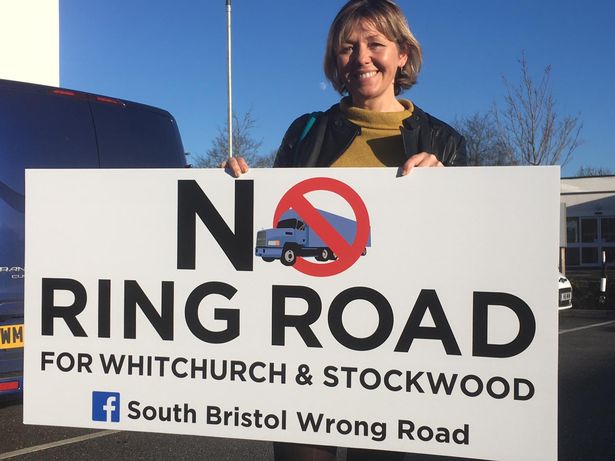
The campaigners in Whitchurch Village previously came together under the ‘South Bristol Wrong Road’ banner, when a plan to open up the countryside around Whitchurch was proposed with a ring road that would connect Hicks Gate on the A4 with Whitchurch Lane in Hengrove.
More than 18 months ago, B&NES planners held a consultation in Whitchurch Village to talk about the next draft of the Local Plan, but fewer than 1,000 new homes were proposed on three sites. Now, the council’s published draft contains a total of more than 5,000 new homes.
Now, the residents are back forming a campaign group, with local councillor Paul May organising Tuesday night’s meeting, which takes place at The Royal Legion, at 8pm tonight. Cllr May will also be joined by the Chair of Whitchurch Parish Council and other local councillors, to help with questions, organisers said.
READ MORE: Plan revealed for South Bristol village to nearly double in sizeREAD MORE: Villagers’ outrage as new suburb proposed on the edge of Bristol
A statement formally objecting to the B&NES plan has been signed by the parish council, the Whitchurch Village Action Group and the South Bristol Wrong Road Group.
“Whitchurch Village is a village and is not an extension to Bristol,” they said. “All of the options are located on critical green belt, that meets most, if not all five of the criteria for declaration of this status.
“If these options are adopted there will be an erosion of the small corridor of green belt separating the village from the city of Bristol,” they added.
“The village has experienced growth in recent years but it is vital to say that we are a village and wish to remain so. The options would add up to 5000+ houses and turn the village into a town of up to 18,000 residents,” they added.
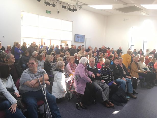 Around 300 residents attended a meeting with Marvin Rees about the South Bristol ring road proposal, back in 2019
“Whitchurch is a village that has already absorbed significant growth, These options would turn the village into a small town, without any additional infrastructure or services to support the growth. The options are all on green belt with no exceptional circumstances to remove the designation. These options would endanger the encroachment of the city into valued open space that characterises the village. This would destroy the very character of the village.
“Some of the sites visually impact on the nearby heritage assets, the historic field pattern so characteristic of the area, high landscape sensitivity, and proximity to the conservation area of Queen Charlton. The Options document itself sets out many risks for development in Whitchurch, yet there is no case made as to why the village has been chosen for massive growth,” they added.