
Snow has been forecasted for 14 different counties in England including Staffordshire and Shropshire
14:06, 26 Apr 2025Updated 15:27, 26 Apr 2025
 Light snowfall has been predicted across parts of the country in a matter of weeks(Image: Graham Young / BirminghamLive)
We’re well into spring and are just two months away from the start of summer.
This year has proved to be a sunny one, with record levels of sunshine recorded in the UK for March.
But like typical British weather, things can change quickly.
READ MORE: Tenerife, Gran Canaria and Lanzarote on brink of major tourism changes as protests planned
Get breaking news on BirminghamLive WhatsApp, click the link to join
While we’re now seeing warmer temperatures after leaving winter behind, we could still see colder conditions ahead.
Forecasters at WX Charts have revealed that snow could be on its way in a matter of weeks.
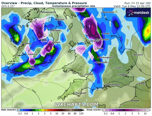 Weather maps from WX Charts have forecasted snow to fall across an 18-hour period(Image: WX Charts)
Snowfall could fall over England on Tuesday, May 6, starting at 6am that day and remaining in spells across different parts of the country for 18 hours, according to wxcharts.com.
At 6am, snow is set to fall over Cumbria, Durham, North Yorkshire, South Yorkshire, Northumberland and further south in Derbyshire and Oxfordshire.
By 12pm, there could be snowfall spread across Lancashire, Greater Manchester, Staffordshire, Derbyshire, Shropshire and Cumbria.
While at 6pm, there could be patches of snow across Lancashire and the East Riding of Yorkshire.
By 12am on Wednesday, May 7, snow is set to linger around North Yorkshire, West Yorkshire, Durham and Northumberland before disappearing.
In its long-range forecast from April 30 to May 9, the Met Office said: “Fine, dry and very warm across the majority of the UK at the start of this period with long clear or sunny spells.
“However, it is expected to be cloudier in the far north with some rain at times.
“Some of this rain will likely spread southwards late next week before clearing to leave a mainly dry and sunny weekend, although with temperatures closer to normal than on preceding days.
“Into the following week, it will probably turn more changeable, with dry, settled periods interspersed with some spells of wetter weather.
“This will bring some showers or longer spells of rain at times, which could be heavy and thundery.
“Temperatures will probably be near normal.”