Forecasters are warning of relentless rain, particularly in the south of Wales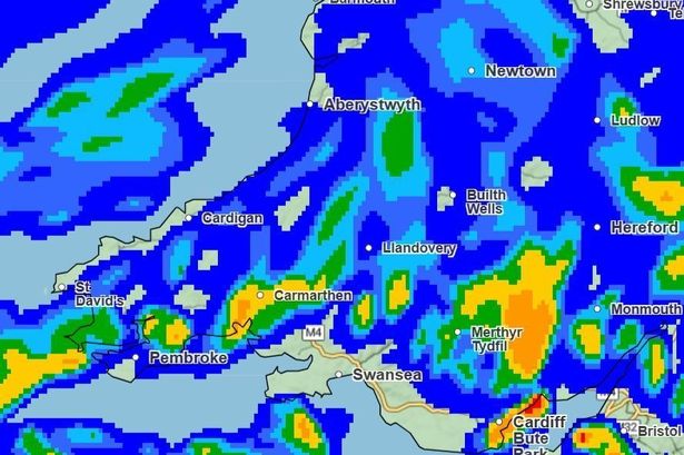 Maps show very heavy rain across Wales(Image: Met Office)
Storm Claudia is set to bring widespread and disruptive rainfall across much of England and Wales from Friday into the early hours of Saturday, with the Met Office issuing amber warnings for heavy rain in parts of the country.
The Met Office has said that the storm is named by Spain’s national meteorological service because of its earlier impacts on the Canary Islands. It is forecast to deliver intense downpours and strong winds as it moves northwards. Amber rain alerts are in place for southern and central areas of England and Wales starting from 6am on Friday, while broader yellow warnings cover much of the country for both rain and wind.
Forecasters are warning of relentless rain, particularly in the south of Wales, where the heaviest and most persistent downpours are likely to cause travel disruption and localised flooding.
It comes as Natural Resources Wales already has more than 20 flood alerts in place across the country.
The places likely to bear the brunt of the rainfall include:
- Blaenau Gwent
- Caerphilly
- Cardiff
- Merthyr Tydfil
- Monmouthshire
- Newport
- Powys
- Rhondda Cynon Taf
- Torfaen
- Monmouthshire
- Powys
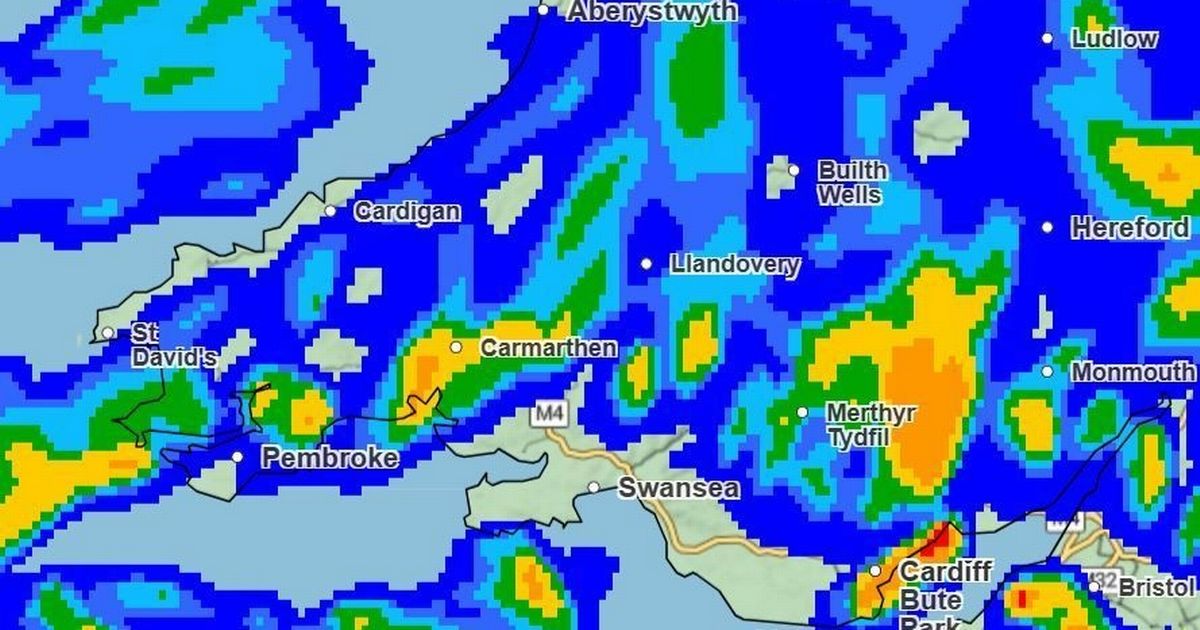
According to the Met Office, rainfall intensity is shown on forecast maps using a colour key – with light blue indicating lighter rainfall and red representing the heaviest downpours.
By Friday afternoon, the map shows bands of rain across much of England and Wales. From around 1pm, which is when Storm Claudia is expected to hit at full force, it looks like many areas will be seeing between 0.5 and 1mm of rain.
Heavier bursts of 2-4mm are likely across Cardiff, Llantwit Major, Burry Port and Monmouth, while Pembroke, Knighton and Newton could see 4-8mm. The heaviest rain looks set to fall around Abergavenny and Hay-on-Wye, where totals may reach 8-16mm.
 Across Wales, areas will be seeing different intensities of rainfall(Image: Met Office)
By 2pm, heavier rain will spread northeast, with a large yellow zone covering areas from Pontypridd through Abergavenny and Monmouth up towards Ludlow and Newton – signifying 4-8mm of rainfall. An orange band, indicating 8-16mm, will stretch from Cardiff north towards Merthyr and Hay-on-Wye.
 Heavier downpour will be spreading, as shown by the map(Image: Met Office)
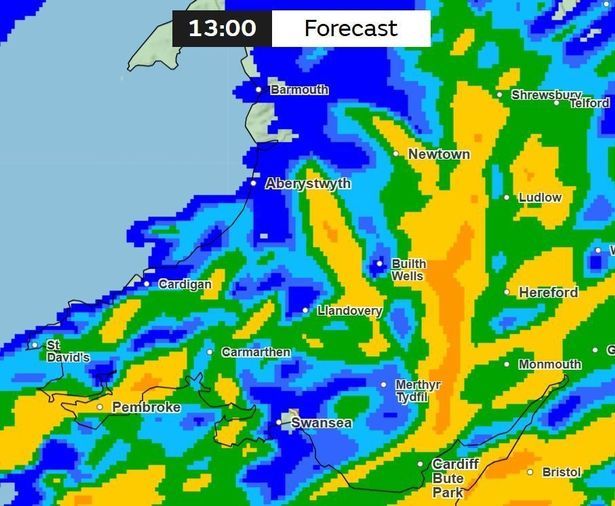
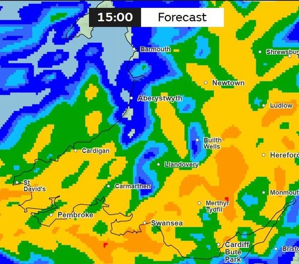
At 3pm, intense rainfall is expected to expand westwards, reaching Swansea and the coast, including Pembroke, St David’s and Cardigan. Spots of red on the rainfall map suggest downpours of up to 16-32mm east of Merthyr.
 It looks to be a turbulent day with areas near Methyr seeing heavy levels of rain(Image: Met Office)
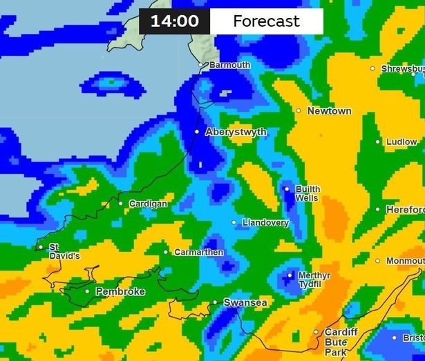
By around 4pm, rain is forecast to ease slightly in some southern areas, including Cardiff, Pembroke, Aberystwyth and Monmouth, where rainfall may drop to around 0.5-1mm. However, Swansea and Llandovery are likely to see 2-4mm, with heavier patches of 4-8mm persisting across mid Wales and northwards towards Wrexham.
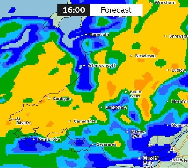 Most areas look to be 4-8mm of rainfall, indicated by the yellow patches(Image: Met Office)
Heading into the evening, around 5pm, the heaviest rain will shift north, affecting mid and north Wales, particularly around Welshpool, Oswestry and Ruthin, where totals of 4-8mm are expected.
Further south along the coast, rainfall will be lighter, with Maesteg, Swansea and Hereford seeing around 0.5-1mm, and Brecon and Pontypridd experiencing slightly heavier falls of 2-4mm.
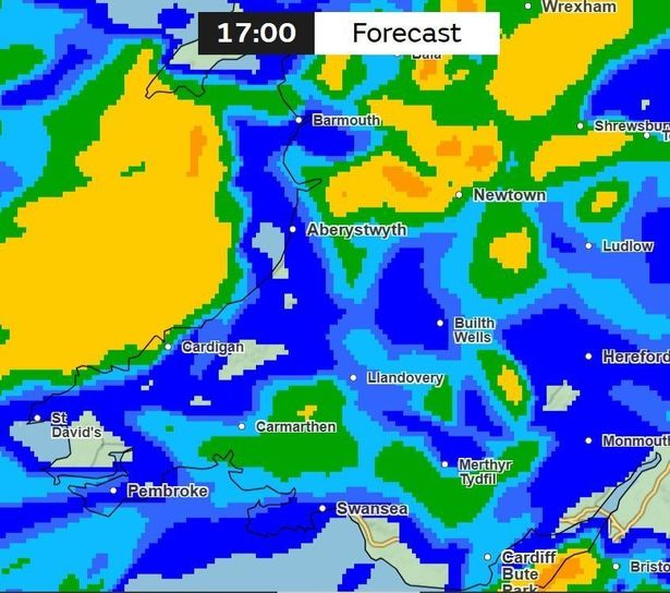 Around 5pm, the heaviest rain will shift north(Image: Met Office)
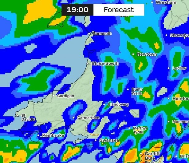
By 6pm, the rain is expected to clear from Swansea, Neath Port Talbot and Ystradgynlais, although some scattered showers may linger. The heaviest rainfall at this time is likely near Monmouth, Caernarfon and St Asaph. For the biggest stories in Wales first, sign up to our daily newsletter here
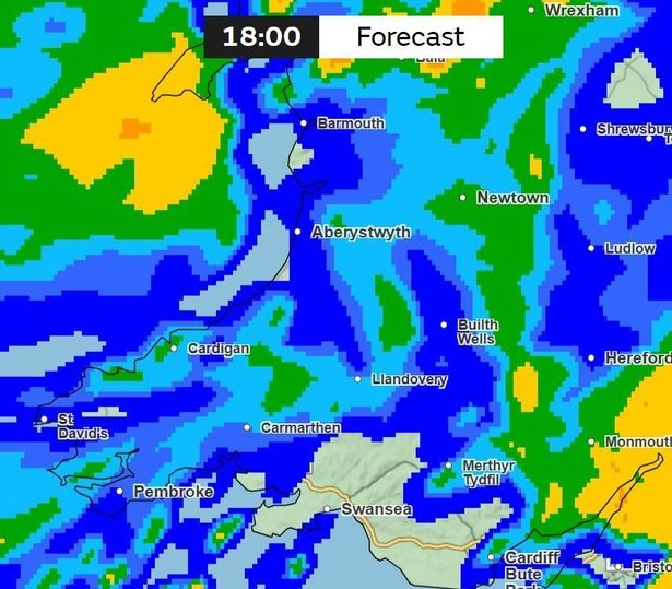 According to the map, rain looks to clear from Swansea, Neath Port Talbot and Ystradgynlais(Image: Met Office)
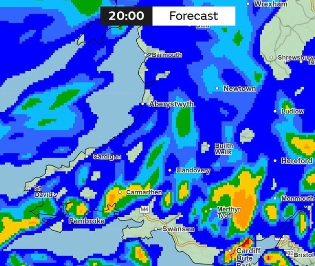
From 7pm, conditions will improve in the west, with clearer skies from St David’s along to Fishguard and Cardigan. However, fresh rain looks set to move in from the south, with spots of red indicating 16-32mm approaching the Cardiff area from the sea. Elsewhere, rainfall amounts will range between 0.5 and 4mm.
 Conditions will improve in the west, with clearer skies from St David’s(Image: Met Office)
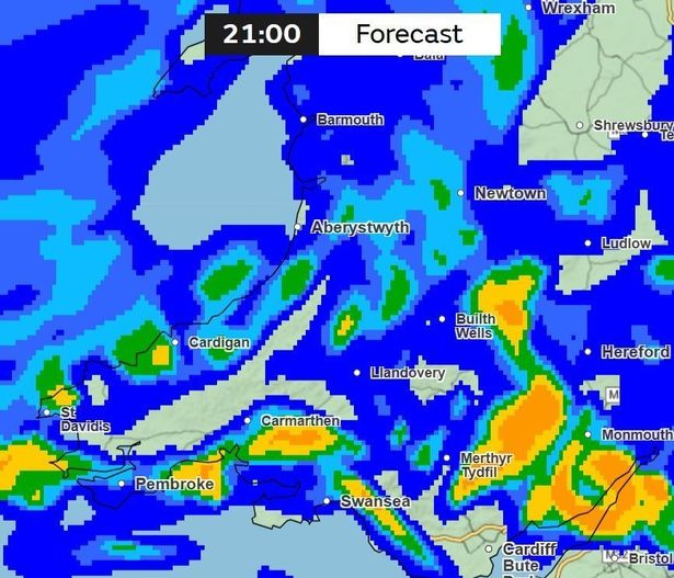
By 8pm, conditions will remain similar, with Abergavenny, Newport and areas up towards Welshpool and Bala seeing 2-4mm of rain. Between Cardiff and Newport, the heavier band of 16-32mm is likely to persist, while most other regions experience lighter rainfall.
 Between Cardiff and Newport, the heavier band of 16-32mm looks likely to persist(Image: Met Office)
From 9pm to 10pm, rain in north Wales should begin to ease, while areas from Builth Wells down to Merthyr could see a mix of moderate rainfall ranging from 2 to 16mm. This unsettled pattern is expected to continue, with Llandovery, Lampeter and Abergavenny also seeing variable conditions.
 Rain in north Wales should begin to ease to a more lighter rainfall(Image: Met Office)
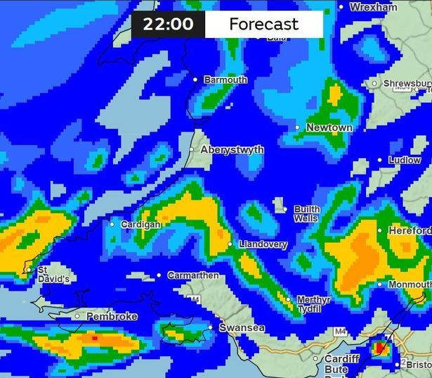 The rain looks to be most intense in the Monmouthshire area, around Abergavenny and Monmouth(Image: Met Office)
Between 11pm and midnight, large parts of the country will experience lighter rain, although some areas such as Cardigan and Machynlleth may still see heavier bursts of 2-4mm.
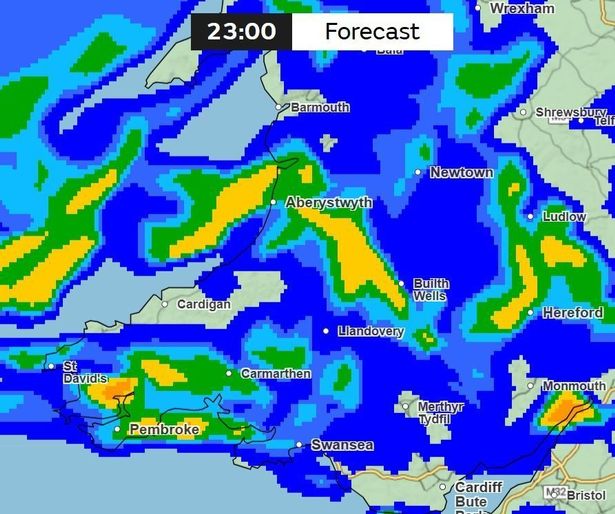 From the map, there are no signs of the rain letting up (Image: Met Office)
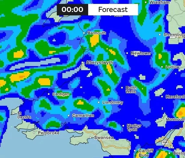 In accordance with the map, it looks like the majority of Wales will be seeing the lighter rainfall as we proceed into Saturday(Image: Met Office)
As a result of the turbulent weather, local councils across the country have issued warnings and advice to it’s residents. One such council is Rhondda Cynon Taff, which has confirmed the closure of several of it’s services:
Friday, November 14
- Grass pitches: CLOSED
- Ynysangharad War Memorial Park: CLOSED 12pm
- Treforest Community Recycling Centre: CLOSED 12pm
- Gas Road Car Park, Pontypridd: CLOSED 5pm
- Henry Street Car Park, Mountain Ash: Vehicles advised to vacate by 5pm
Saturday, November 15
- Grass pitches: CLOSED
- Lido: CLOSED
- Cemeteries and Crematoria: CLOSED
- Ynysangharad War Memorial Park: TBC
- Treforest Community Recycling Centre: TBC
The AA has urged motorists to avoid travelling in the hazardous conditions, warning that “safety comes first” and advising drivers to stay updated as conditions “may change quickly.” It also cautioned against driving through flood water, noting that even shallow depths can be dangerous.
The Environment Agency has said that parts of northern England are already experiencing minor surface water and river flooding. It confirmed that teams are working closely with emergency services and local authorities to prepare for further impacts as the storm moves through.
Flood duty manager Ben Lukey said: “Storm Claudia will bring heavy, prolonged rainfall across parts of England, with significant surface water flooding probable across central regions on Friday. River flooding is also possible tomorrow and into Saturday.”
He added: “Environment Agency teams are on the ground clearing debris from watercourses and are ready to operate flood defences as needed.”