
Train services are still disrupted this morning
09:22, 15 Nov 2025Updated 09:30, 15 Nov 2025
 File image of heavy rain in Bristol (Image: PAUL GILLIS / Reach PLC)
Six flood warnings and two flood alerts remain in place in the Bristol area this morning (Saturday, November 15) following torrential rain yesterday. The Floating Harbour, three towns and several rural villages are among the locations affected due to rising water levels along the rivers Frome, Boyd, Chew and Avon.
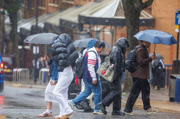
Conditions in most areas are expected to improve today following travel chaos last night, with train journeys cancelled and a two-hour delay on the M5.
Great Western Railway has told passengers to expect continued disruption on certain lines, including between Swindon and Bristol Parkway and between Gloucester and Bristol Parkway. All lines have now reopened but disruption is expected until midday.
The Environment Agency’s map, below, shows the areas most at risk. Flood warnings are more serious compared to flood alerts, and mean that flooding is “expected” and people in the warning zone should “act now”.
Flood warnings
Bristol Frome at Chipping Sodbury and Yate, Vayre Close, Manor Way, Celestine Road and Nibley Lane
This was last updated at 8pm last night and is due to be amended this morning if the situation changes. It states: “Flooding is expected on 14 November 2025. Areas most at risk include Vayre Close and Manor Way in Chipping Sodbury, properties closest to the river at Celestine Road in Yate and the Stover Bridge and Nibley area. Drier conditions are forecast from Saturday and conditions will begin to improve.”
Bristol Frome from downstream of Nibley to Stapleton
Last updated at 9.20pm last night, this warning is set to remain in place throughout today. It states: “Areas most at risk include Rectory Road at Frampton Cotterell. Flooding is forecast to affect locations near the Bristol Frome, with low lying land and roads expected to be most affected.”
River Boyd at Wick
This warning was updated at 7pm last night and should be reassessed this morning. It advises: “Areas most at risk include downstream of the A420 Bridge at the Paper Factory on Church Road and The Green on Barrow Hill, properties at Wick and downstream of Boyd Bridge. Drier conditions are forecast from Saturday and conditions will begin to improve.”
River Chew from Stanton Drew to the Bristol Avon at Keynsham
Last updated at 5.40pm last night, the warning states: “Areas most at risk include the Old Mill Leat at Stanton Court. There is a risk of property flooding at Bye Mills, Church Street at Pensford, Woollard, Compton Dando and Chewton Place. At Keynsham there is a risk of flooding to properties at the bottom of Dapps Hill, particularly at Alice Mews.
“Flooding is forecast to affect locations near the River Chew, with low lying land and roads expected to be most affected, particularly areas around the Old Mill Leat at Stanton Court. There is a risk of property flooding at Bye Mills, Church Street at Pensford, Woollard, Compton Dando.”
Winford Brook at Chew Magna
Updated at 7pm last night, the warning for Chew Magna says: “Flooding is forecast to affect locations near the Winford Brook. Areas most at risk include the road at The Batch and Streamleaze. Conditions are expected to improve from Saturday 15/11/2025.”
Chew Stoke Stream and River Chew at Chew Stoke and Chew Magna
The second warning for the Chew Magna area states: “Flooding is forecast to affect locations near the Chew Stoke Stream, River Chew, with low lying land and roads expected to be most affected, particularly around Mill Lane, properties on The Street and access to School Lane and Chew Stoke primary school in Chew Stoke. Water will be deep and fast flowing at the fords on Mill Lane and Pilgrims Way. Flooding will also affect Dumpers Lane, Tunbridge Close and Tunbridge Road in Chew Magna.”
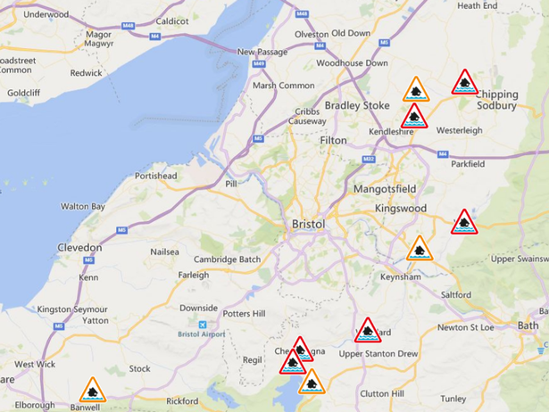 The flood warnings (red) and alerts (orange) shown on the EA’s map(Image: Environment Agency)Flood alerts
Flood alerts are for areas where flooding is “possible” and people within the area should “be prepared”.
Bristol Frome catchment
This alert has not been updated since Friday afternoon but still advises: “Flooding is forecast to affect locations near the Bristol Frome, Bristol Floating Harbour, with low lying land and roads expected to be most affected. Areas most at risk include St John’s Way in Chipping Sodbury and Damson Bridge. Drier conditions are forecast from Saturday and conditions will begin to improve.”
Lower Bristol Avon area
“Areas most at risk include low lying land at Hanham Lock and the floodplain upstream of Bath. Flooding is forecast to affect locations near the Bristol Avon, Broadmead Brook, River Boyd, with low lying land and roads expected to be most affected, particularly around Areas most at risk include low lying land at Hanham Lock and the floodplain upstream of Bath.” The alert was last updated at 6pm last night.