Storm Bram is bringing heavy rain and high winds to the UK as the Met Office issued three amber weather alerts and warned of a danger to life.
The Met Office has announced three amber warnings, meaning the weather is potentially life-threatening, and a series of yellow warnings for wind and rain on Monday, Tuesday and Wednesday across England, Wales, Scotland and Northern Ireland.
Storm Bram, named by Met Eireann, Ireland’s equivalent of the Met Office, could bring winds of up to 90mph to the north west of Scotland, where there is an amber wind warning from 4pm until midnight on Tuesday.
The Met Office said flying debris in that area could result in a danger to life, while roads, bridges and railway lines may close and there could be power cuts and damage to buildings.
There are also two amber rain warnings for midnight to 10am on Tuesday, one covering Cornwall and Devon and the other in south east Wales, where fast flowing or deep floodwater is likely, causing danger to life, while there is a good chance some communities will be cut off by flooded roads and power cuts are likely.
In those amber areas, between 50mm and 75mm of rain is expected, most of which will fall in just nine hours, while a few exposed locations may see about 100mm of rain, more than half the average monthly rainfall for the whole of December.
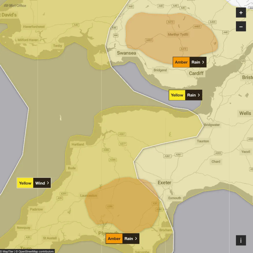
There are two amber warnings for rain in England on Tuesday. (Met Office)
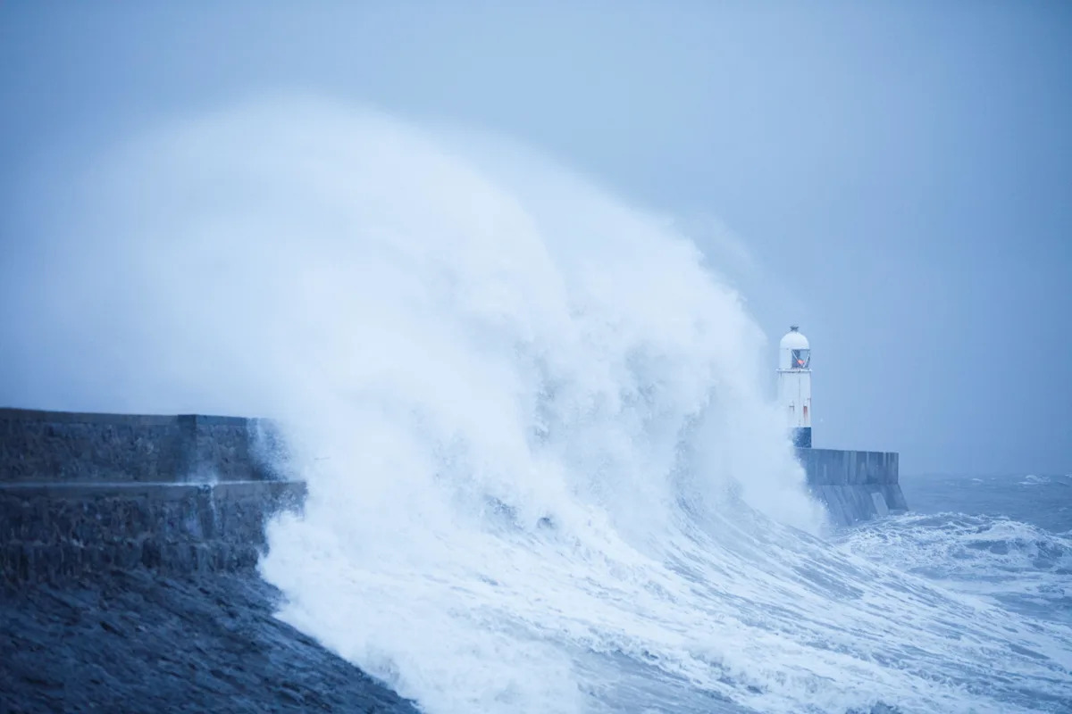
On Monday, a weather warning for strong winds starts at 10pm on Monday and finishes at 4pm on Tuesday, and covers Dorset and Cornwall in the south west of England but stretches all along the west coast of Wales.
Power outages are possible, as is transport disruption, with delays for high-sided vehicles on exposed routes and bridges, while coastal roads and seafronts will be affected by spray and large waves.
Gusts of up to 50mph are expected in most areas, but winds of between 60mph and 70mph are possible along exposed coasts and high ground. The Met Office said there is a small chance of winds over 70mph in north west Wales.
From 6pm on Monday until 2pm on Tuesday, there is a yellow warning for rain that covers a similar but slightly larger area, spreading east into Hampshire and Oxfordshire, potentially causing flooding of homes and businesses amid warnings that some communities could be cut off.
Despite the wet and windy weather, places in the south west of England will see temperatures as high as 15C on Tuesday, while it could reach 16C in Wales, the West Midlands and the North West.
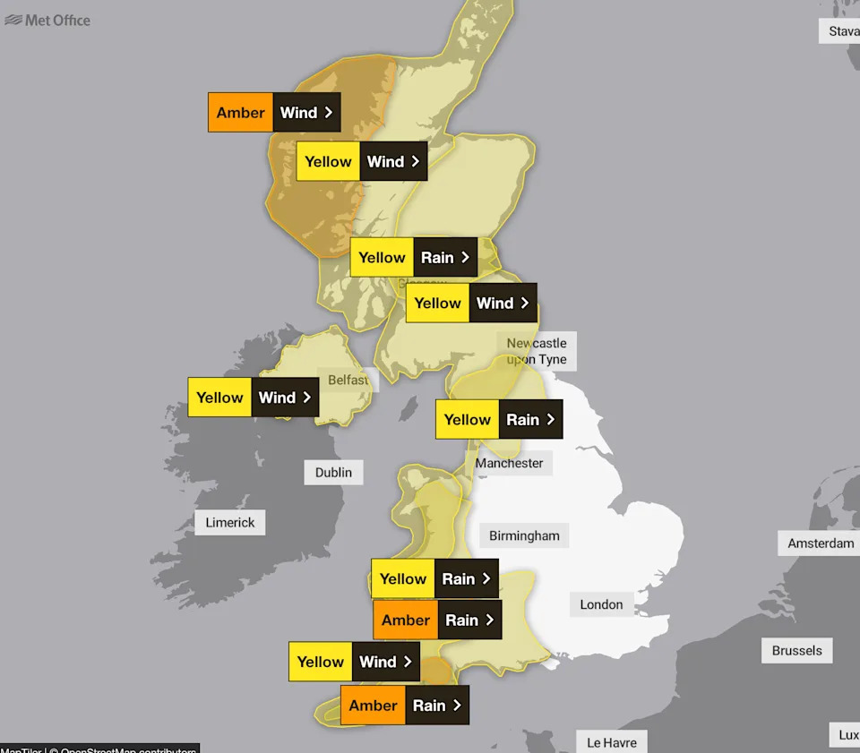
Much of the UK is under a weather warning on Tuesday. (Met Office)
More yellow warnings for wind and rain on Tuesday are in place for the whole of Scotland, the whole of Northern Ireland, and much of the North West and North East of England.
As of Monday afternoon, there were 12 flood warnings in place across England, meaning flooding is expected, with a further 65 flood alerts, meaning flooding is possible, according to the Environment Agency.
The Met Office said the unsettled weather is being caused by a powerful jet stream moving across the Atlantic brining low pressure.
Met Office deputy chief meteorologist Dan Holley said: “Whilst there is some uncertainty as to the exact track and intensity of the area of low pressure as it passes close to western Scotland later on Tuesday, many parts of the UK are likely to see spells of rain which, given saturated ground, could lead to flooding and delays to road and rail travel.
“In addition, strong winds are expected, particularly in northern and western areas. We are closely monitoring developments and may issue updates to the warnings as the situation evolves.”
Yahoo breaks down what the weather will be like for each region of the UK, according to the Met Office.
London and the South East
Mostly dry and bright early Monday morning and the brisk winds will continue. Cloud increasing with some showers and occasional rain likely by early afternoon. Winds easing for a time in afternoon. Maximum temperature 14°C.
Windy start to Tuesday with heavier bursts of rain clearing. Mostly cloudy, before clearer weather arrives from the west. Strong winds and coastal gales easing later. Very or exceptionally mild. Maximum temperature 14°C.

A rainy day in London’s Piccadilly Circus on Sunday 7 December. (Getty Images)
Bright on Wednesday with some blustery showers. Winds easing for Thursday with bright or sunny spells. Overnight stronger winds with rain clearing by Friday afternoon. Temperatures mostly above normal.
South West
Showers quickly clearing, leaving brighter skies for a time. Cloud then thickening with perhaps some showery rain in places. Another mild day. Heavy rain arriving later and through this evening. Maximum temperature 13°C.
Mainly cloudy on Tuesday with outbreaks of rain and drizzle through the morning, heavy over higher ground at first. Brightening up through the afternoon. Gales easing but staying windy. Exceptionally mild. Maximum temperature 15°C.
Drier and brighter on Wednesday with sunny periods and isolated showers. Probably dry with bright spells on Thursday. Rain likely at times on Friday. Often rather windy. Staying very mild.
Midlands
Any early showers soon clearing to leave a mainly dry morning with sunny periods and isolated showers. Turning cloudier through this afternoon with scattered showers. Breezy but winds gradually easing. Another mild day for early December. Maximum temperature 12°C.
Mainly cloudy on Tuesday with occasional periods of rain and drizzle through the morning, most persistent over hills. Brightening up through the afternoon. Windy with upland gales possible, easing later. Exceptionally mild. Maximum temperature 16°C.

People in Stratford-upon-Avon, Warwickshire, during the wet weather. (PA)
Drier and brighter on Wednesday with sunny periods and isolated showers. Probably dry with bright spells on Thursday. Rain likely at times on Friday. Often rather windy. Staying very mild.
North East
A band of rain and showers likely around dawn then mostly dry weather following with spells of sunshine and the fresh winds continuing. A few showers possible in the afternoon, mainly across western areas. Winds easing later. Maximum temperature 11°C.
Wet and windy start to Tuesday. Drier and brighter by afternoon with further strong winds and a chance of gales. Very or exceptionally mild by afternoon. Maximum temperature 15°C.
Bright on Wednesday with blustery showers. Winds easing for Thursday with bright or sunny spells. Overnight stronger winds with rain clearing by Friday afternoon. Temperatures mostly above normal.
North West
Any early showers soon clearing to leave a mainly dry day with sunny periods. Isolated showers remain possible, these mainly in coastal regions. Breezy in places and another mild day for early December. Maximum temperature 12°C.
After a very wet start to Tuesday, slowly turning somewhat drier. Occasional lighter periods of rain and drizzle continuing, especially over higher ground. Windy with gales in places, easing later. Exceptionally mild. Maximum temperature 16°C.
Brighter on Wednesday with sunny periods and isolated heavy showers. Probably dry with bright spells on Thursday, though rain possible later and into Friday. Often rather windy. Staying very mild.

A public Christmas tree reflected in a puddle in Blue Town high street in Sheerness, Kent. (Alamy)
Scotland
A dry start with bright spells but showers over the south move northwards through the morning. Showers heavy at times. Showers dying out to leave a largely dry afternoon with bright or sunny spells developing, especially in Tayside and Angus. Maximum temperature 9°C.
Cloud and heavy rain spread north through Tuesday morning, clearing early afternoon for a brief dry spell before rain returns into the west later. Winds strengthen, with coastal gales developing. Maximum temperature 14°C.
Sunny spells and showers on Wednesday with a risk of coastal gales. Thursday and Friday remain mostly cloudy with occasional rain interspersed with dry periods, and breezy at times.
Northern Ireland
A mostly dry morning with bright and sunny spells. Cloudier in the afternoon with some heavy showers breaking out. Many areas staying dry though with some bright spells. Maximum temperature 10°C.
Heavy rain clearing northwards through Tuesday morning. Remaining mostly cloudy with some light outbreaks of rain possible, but many staying dry in the afternoon. Strong winds and risk of gales. Maximum temperature 14°C.
Sunny spells and showers on Wednesday with a risk of coastal gales. Thursday and Friday remain mostly cloudy with occasional rain interspersed with dry periods, and breezy at times.
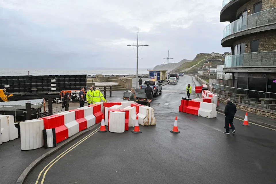
Temporary flood barriers being deployed on the seafront at West Bay, Dorset, ahead of Storm Bram. (Alamy)
Wales
Any heavy showers clearing quickly to leave a generally brighter day with some morning sunny spells. Turning cloudier in the south this afternoon with showers possible. Breezy but winds gradually easing. Another mild day for early December. Maximum temperature 13°C.
Mainly cloudy with outbreaks of rain and drizzle through Tuesday morning, heavy over higher ground at first. Brightening up through the afternoon. Severe gales easing but staying windy. Exceptionally mild. Maximum temperature 16°C.
Drier and brighter on Wednesday with sunny periods and isolated showers. Probably dry with bright spells on Thursday. Rain likely at times on Friday. Often rather windy. Staying very mild.