An artist has created a map showing how the London Underground would look if the Tube network were flipped so that South London had most of the stations instead of North London There are way more Tube stations in North London than South(Image: Richard Baker / In Pictures via Getty Images)
Anyone living along the proposed Bakerloo line extension route will know all too well that when it comes to the Tube map, those south of the Thames get a raw deal compared to their northern counterparts.
Whilst more than 250 stations serve the north side of the river, a paltry 33 cater for the south – including the two most recent additions at Battersea Power Station and Nine Elms, which launched on September 20, 2021 as part of the Northern line Extension. That said, South London does benefit from sections of the London Overground, trams, Thameslink services and the DLR.
Vast areas of the capital are simply overlooked by the Underground network, with the Northern line making the deepest penetration into southern territory, whilst the Victoria, Jubilee and Bakerloo lines also maintain a reasonable footprint.
Now, Colour Country has produced a map reimagining what the Underground would look like if the north-south imbalance were flipped. The redesigned map extends southward through Bromley and into Kent, with Tunbridge Wells, West Malling, Sevenoaks and Dartford all gaining stations.
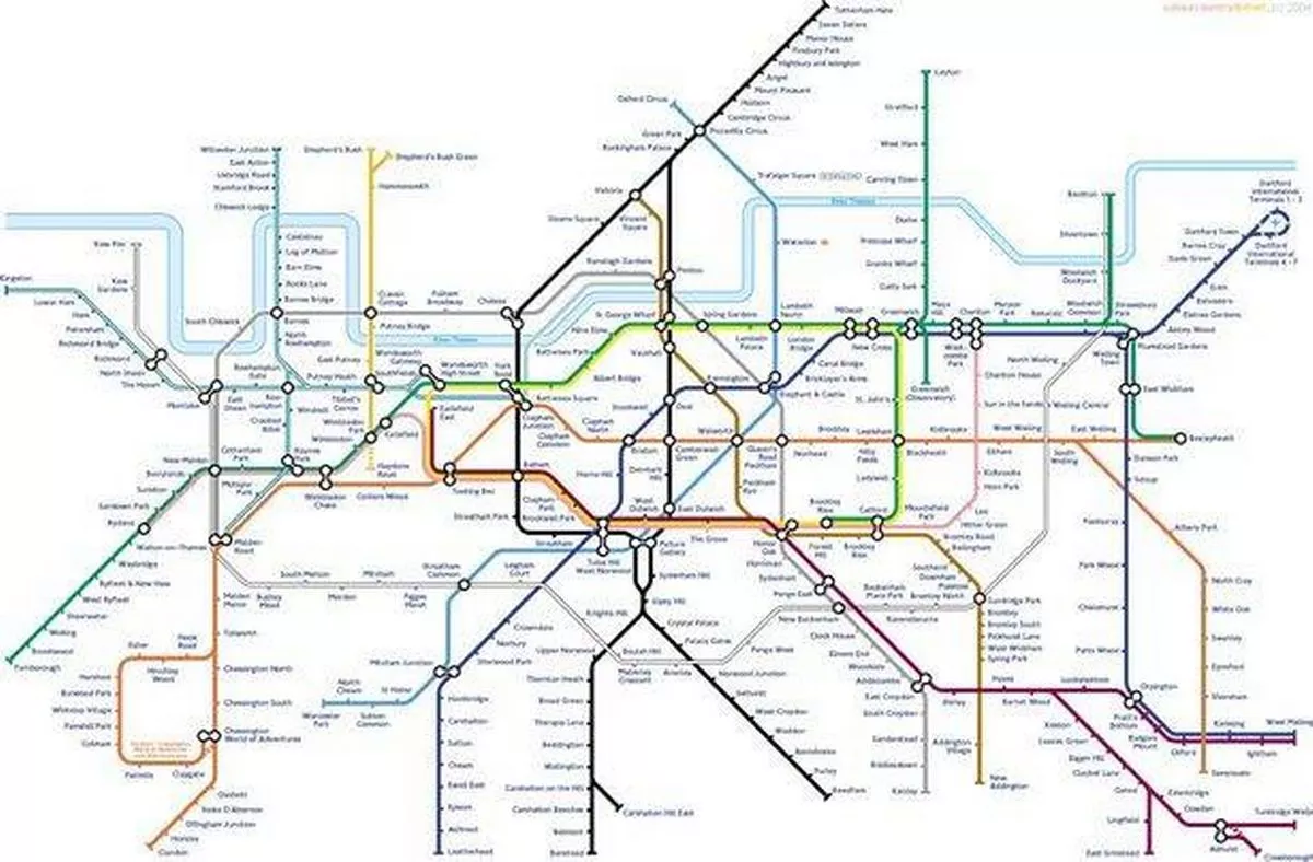 The reimagined map leaves the south much more connected(Image: colourcountry.net)
Explaining the concept, the map’s creator said: “The London Underground map, rearranged so that South London gets most of the stations. The lines and river are identical to the real Tube map, but rotated so that Castelnau exchanges places with the Isle of Dogs: the axis of the river’s rotational symmetry passes roughly through the London Eye.
“It has been pointed out that Kew Gardens and Silvertown stations can be found one from each end of the North (South?) London Line in both this and the real map, which is a nice coincidence.”
Why there are so few Tube stations in South London
The Underground was originally designed to connect various mainline railway terminals with each other, offering an alternative to congested road traffic. As these major stations were located in North London, it’s logical that the earliest Tube stations were also built north of the Thames.
The network was also intended to give growing suburban areas better links to central London – places like Edgware on the Northern line scarcely existed before the Underground arrived – and they feature the same suburban housing style as Sidcup, Orpington and Dartford.
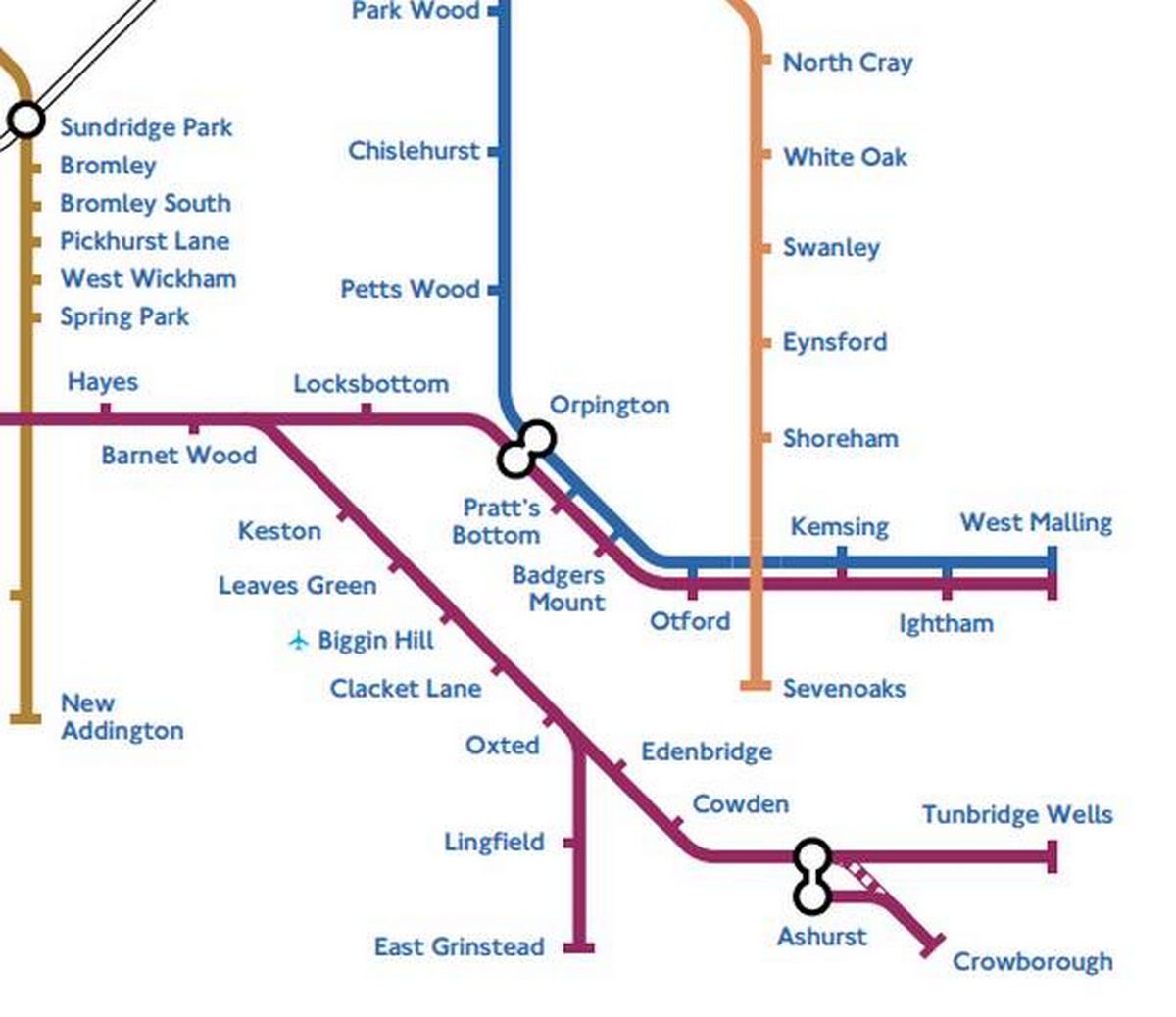 A line focused heavily on the south would go out to West Malling, Kent(Image: colourcountry.net)
That’s because they were all built during the same era – the 1930s, when London began expanding beyond its original boundaries – but South London simply didn’t benefit from the same level of infrastructure investment as its northern counterpart. The original city of London, established by the Romans, was situated north of the River Thames and expanded into areas such as Westminster.
South London, however, was largely overlooked, with now densely populated areas like Croydon or Clapham being essentially rural at that time. Essentially, growth and demand were concentrated in the north, leading to the construction of stations in these areas.
The terrain factor
The ground conditions in the south also played a significant role. The clay soil in the north was ideal for early Tube tunnel digging, while the harder ground in the south proved less accommodating.
In 2017, Croydon Council expressed a keen interest in extending the Tube from Lewisham to Elmers End and then East Croydon. However, a report suggested that any Underground route using existing rail connections would result in a slower service with fewer trains than the current National Rail services.
Furthermore, it pointed out that a tunnelled route from Elmers End to East Croydon would significantly impact the built and natural environment due to a lack of suitable areas for construction and tunnelling works.
Central London railway stations
Another contributing factor to the abundance of Tube stations in the north was the presence of large railway stations constructed there in the 1800s, including Kings Cross, Paddington, Euston and St Pancras.
The Royal Commission’s 1846 ruling that barred trains from fully entering the City of London marked these stations as the final stop for many commuters. As road congestion in London escalated, there was a growing need for alternative means of transport between the City and these stations, leading to the birth of the London Underground.
South London, despite having fewer Tube stations, is home to an extensive National Rail network. In the 19th century, while major train companies were thriving in London, smaller private firms were busily building a complex rail system in the south.
By the time the Underground had firmly established itself around the City of London and began expanding southwards, they found they were already playing catch-up.
Sign up for our London Underground newsletter for the latest travel updates to make your commute easier, plus a weekly fix of Tube trivia! Sign up HERE.