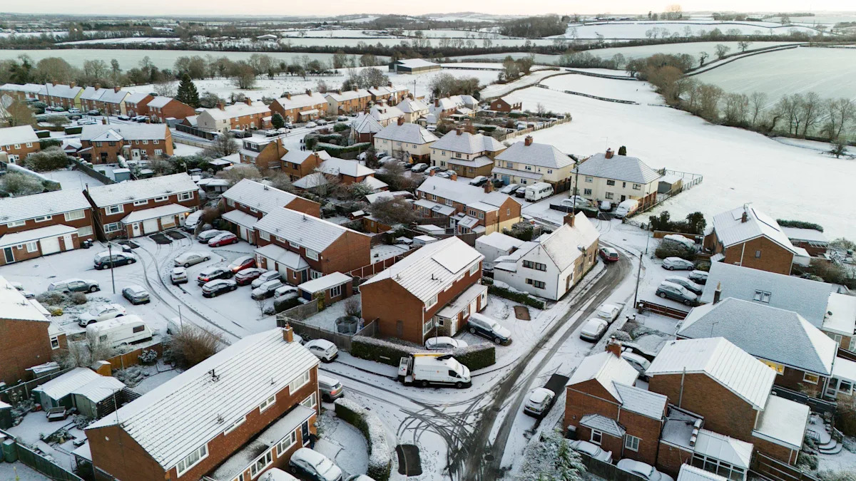
Snow and ice is forecast for parts of the UK in the coming days, bringing potential travel disruption as weather warnings remain in place for large swathes of the country.
Warnings for snow and ice have been issued covering significant areas of the UK, although some which previously included London and the south east of England have now been scaled back.
But others have been extended, such as the yellow snow and ice alert for eastern England which was brought into force a day early on Friday.
In addition, amber snow warnings started at noon on Friday for parts of northern Scotland, where heavy snowfall already caused difficulties for motorists in the Highlands and north-east of the country on New Year’s Day.
Blizzard-like conditions are expected on Friday and are set to continue into the weekend.
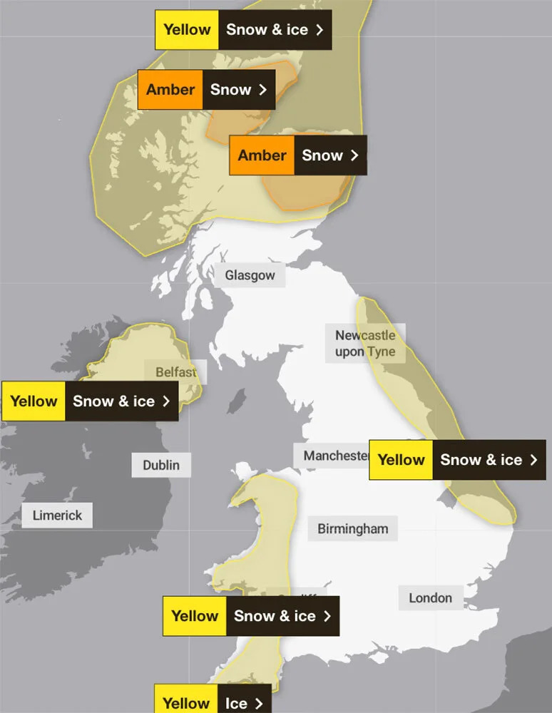
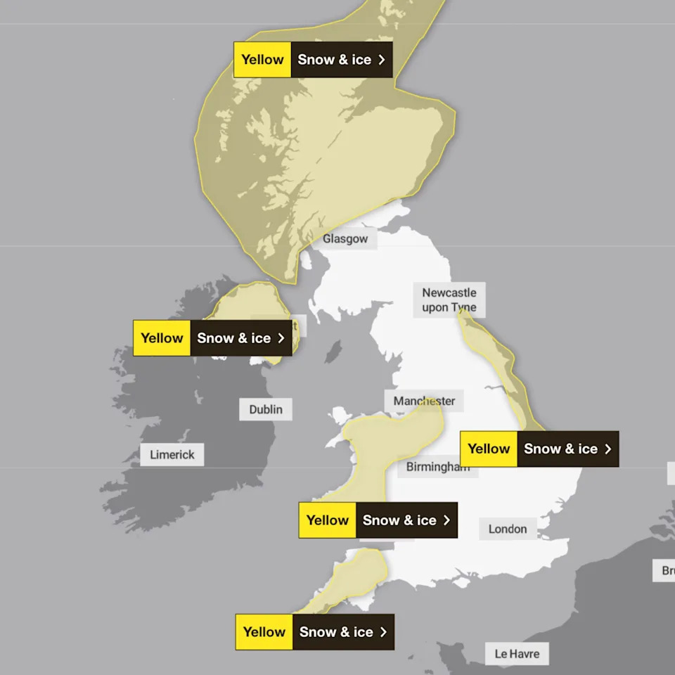
Several weather warnings remain in place for Friday in western and northern areas of the UK. (Met Office)
The amber warnings for snow are in place until at least noon on Saturday, covering areas within a wider yellow weather warning. A separate yellow warning is in place for Northern Ireland until 12pm on Saturday, but will then be replace by a separate alert covering most of the province to run until Monday.
The Met Office warned that Friday could bring snow of up to 20cm on low ground and up to 40cm on higher ground, with the amber areas in Scotland at risk of power cuts and vehicles becoming stranded.
Travel disruption is also expected elsewhere as wintry weather moves southeastwards over parts of England and Wales on Friday, prompting authorities to urge people to prepare for longer journey times by road, and on bus and train services.
The AA has estimated the number of car journeys was likely to reach 20.7 million across the UK on Friday.
Met Office chief meteorologist Rebekah Hicks said: “Arctic air and brisk northerly winds are gripping the UK as we start the new year.
“Snow and ice warnings remain in force for many areas, with the risk of heavy snow showers, especially across northern Scotland and over higher ground elsewhere, though many inland areas will stay largely sunny and clear.
“Bitterly cold conditions will persist through the weekend and into next week, with daytime temperatures struggling to rise above freezing for some, and overnight lows dipping to minus double figures in places.”
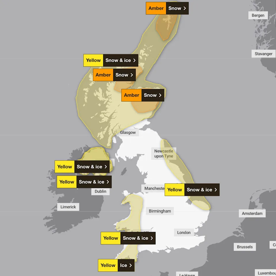
Saturday sees amber alerts for snow remain in place for northern Scotland, along with a yellow warning for snow and ice in Northern Ireland, Wales, Devon and Cornwall and the east coast of England. (Met Office)
A yellow warning for snow and ice is in place for the eastern coast of England between Northumberland and Norfolk and is due to remain in force until midnight on Saturday. A similar alert but covering a smaller area will also be in force for several hours on Monday.
The UK Health Security Agency (UKHSA) has issued severe warnings for the start of the year that run until 10am on 6 January, amid concerns that the weather is “likely” to cause significant impacts across health and social care services, including a “rise in deaths” among those with health conditions or aged 65 or over.
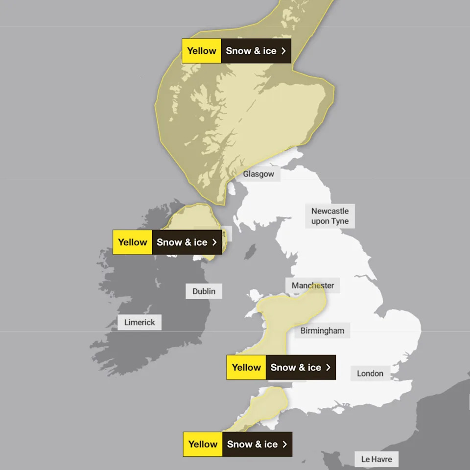
By Sunday the weather risk is expected to have receded slightly in Scotland, but yellow warnings will remain in place there, as well as elsewhere in the UK. (Met Office)
By Sunday, Scotland’s amber alerts are expected to have ended, but yellow warnings will remain in place for swathes of the country.
Health Secretary Wes Streeting warned the “bitingly cold” weather was likely to put hospitals under greater pressure.
He said: “We still face intense pressures, and with this bitingly cold snap adding additional challenges, it is more vital than ever those eligible get their flu jab and people only attend A&E in an emergency.”
Yellow warning for snow and ice are expected to persist until Monday afternoon. (Met Office)
Where will it snow?
The Met Office previously issued a yellow warning for snow and ice across large parts of England and Wales between midnight on 31 December and noon on 2 January, although this has since been scaled back.
Between Friday and Monday, parts of South-west England have been told to expect snow and ice, as well as parts of the West Midlands and the North-east, and areas along the eastern coast of England between Northumberland and Norfolk.
Similar warnings will be in place for most of Wales and Northern Ireland over the period.
Amber snow warnings were issued for northern Scotland running from noon on Friday until noon on Saturday. Separate yellow warnings are in place for Northern Ireland until 10am on Friday.
The Met Office’s five-day UK weather forecast has predicted a “cold and frosty start for all on Saturday”. with the chance of snow showers “across windward coasts”, particularly in Scotland, and the chance of snow persisting into Tuesday.
The long range forecast for 6-15 January suggests milder temperatures could be on their way, and the snow will remain a possibility in northern, eastern and central parts of the UK.
Beyond this, however, there is littler certainty, with the forecaster stating: “The outlook through January is very uncertain, with no strong indication for any particular weather pattern to dominate.”
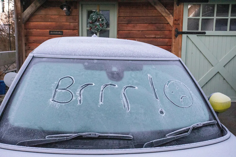
Much of the UK is expected to see frost and snow over the coming days. (Alamy)
“As such, conditions are most likely to be changeable.
“Spells of wet, windy and mild weather are possible at times, along with colder, drier interludes with overnight frost and fog.”
Where are the cold weather alerts?
Amber cold health alerts have been issued by the UK Health Security Agency (UKHSA) for every county in England.
The agency had previously issued amber cold health alerts in the North East and North West of England, with yellow alerts elsewhere but the latter were upgraded to to amber across the East Midlands, West Midlands, South East, South West, East of England, Yorkshire and the Humber, and London.
The UKHSA only covers England, and equivalent organisations in Wales, Scotland and Northern Ireland have not issued similar warnings.
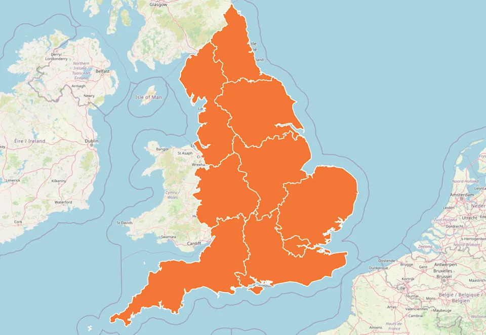
Amber cold weather health alerts have previously been issued for every county in England by the UK Health Security Agency. They are due to last until 9 January.
Regional forecastsLondon and South East England
Saturday: After a very frosty start temperatures will struggle to rise above freezing for many areas, despite a largely sunny day. After dark temperatures rapidly fall below freezing again. Maximum temperature 2 °C.
Sunday to Tuesday: Mostly dry and sunny, but cold throughout with widespread overnight frosts and an increasing chance of freezing fog patches which will be slow to clear each day.
South West England
Saturday: Continuing wintry showers in the west bring the chance of icy patches on untreated surfaces. Dry in the east with plenty of sunshine. Still cold, particularly with the ongoing breeze. Maximum temperature 6 °C.
Sunday to Tuesday: Very similar on Sunday and Monday: cold but largely dry with winter sunshine by day and frost by night. Perhaps cloudier on Tuesday with some rain and hill snow possible.
East of England
Saturday: Cloudier conditions will gradually extend southwards across the region as snow showers arrive across Norfolk, these mostly isolated but becoming frequent and heavy across northeast Norfolk. Feeling bitterly cold. Maximum temperature 2 °C.
Sunday to Tuesday: Mostly dry and sunny by day and clear overnight with widespread sharp frosts and an increasing chance of patchy freezing fog. Coastal wintry showers Sunday and Monday, sometimes heavy. Cold.
West Midlands
Saturday: Plenty of sunshine throughout Saturday and staying dry. However, still feeling cold, particularly with the ongoing breeze. Frosty again overnight. Maximum temperature 3 °C.
Sunday to Tuesday: Very similar on Sunday and Monday: cold but largely dry with winter sunshine by day and frost by night. Perhaps cloudier on Tuesday with some rain and hill snow possible.
East Midlands
Saturday: Frequent heavy snow showers will develop along the Lincolnshire coast, perhaps bringing travel disruption. Dry and brighter elsewhere. Windy along the coast and breezy inland, and feeling bitterly cold everywhere. Maximum temperature 2 °C.
Sunday to Tuesday: Mostly dry and sunny or clear, and widespread sharp overnight frosts with an increasing chance of patchy freezing fog. Coastal wintry showers Sunday, probably easing later Monday. Cold. Often breezy.
Yorkshire and Humberside
Saturday: Frequent heavy snow showers will reach coastal areas, and may move slightly inland, perhaps bringing travel disruption. Dry and brighter elsewhere. Windy, chance of coastal gales, and feeling bitterly cold. Maximum temperature 2 °C.
Sunday to Tuesday: Mostly dry and sunny or clear, and widespread sharp overnight frosts with an increasing chance of patchy freezing fog. Coastal wintry showers Sunday, probably easing later Monday. Cold. Windy initially.
North West England
Saturday: Plenty of sunshine throughout Saturday and staying dry. However, still feeling cold, particularly with the ongoing breeze. Frosty again overnight. Maximum temperature 4 °C.
Sunday to Tuesday: Very similar on Sunday and Monday: cold but largely dry with winter sunshine by day and frost by night. Perhaps cloudier on Tuesday with some rain and hill snow possible.
North East England
Saturday: Frequent heavy snow showers will reach coastal areas, and may move a little way inland, perhaps bringing travel disruption. Windy, with a chance of coastal gales, and feeling bitterly cold. Maximum temperature 1 °C.
Sunday to Tuesday: Mostly dry and sunny or clear, and widespread sharp overnight frosts with an increasing chance of patchy freezing fog. Coastal wintry showers Sunday, probably easing later Monday. Cold. Windy initially.
Scotland
Saturday: A similar day to Friday with snow showers possible near eastern coasts. Otherwise a dry day with a good deal of sunshine. Remaining very cold with bitter winds. Maximum temperature 3 °C.
Sunday to Tuesday: Very cold and frosty. Mainly dry Sunday and Monday with sunny spells, though cloudier near coasts with isolated snow showers. A band of rain and snow spreads eastwards on Tuesday.
Wales
Saturday: Continuing wintry showers in the west bring the chance of icy patches on untreated surfaces. Dry in the east with plenty of sunshine. Still cold, particularly with the ongoing breeze. Maximum temperature 5 °C.
Sunday to Tuesday: Very similar on Sunday and Monday: cold but largely dry with winter sunshine by day and frost by night. Perhaps cloudier on Tuesday with some rain and hill snow possible.
Northern Ireland
Saturday: Another cold day with snow showers, which may be heavy at times. Dry and bright spells between showers. Breezy with a bitter wind chill, especially near coasts. Maximum temperature 4 °C.
Sunday to Tuesday: Remaining cold or very cold through the period with occasional wintry showers Sunday and Monday. A band of rain and snow spreads eastwards on Tuesday. Often breezy, especially near coasts.