Your support helps us to tell the story
From reproductive rights to climate change to Big Tech, The Independent is on the ground when the story is developing. Whether it’s investigating the financials of Elon Musk’s pro-Trump PAC or producing our latest documentary, ‘The A Word’, which shines a light on the American women fighting for reproductive rights, we know how important it is to parse out the facts from the messaging.
At such a critical moment in US history, we need reporters on the ground. Your donation allows us to keep sending journalists to speak to both sides of the story.
The Independent is trusted by Americans across the entire political spectrum. And unlike many other quality news outlets, we choose not to lock Americans out of our reporting and analysis with paywalls. We believe quality journalism should be available to everyone, paid for by those who can afford it.
Your support makes all the difference.Read more
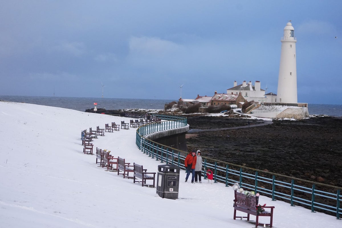
Blizzard conditions are set to hit parts of the UK as numerous amber and yellow winter weather warnings for snow and ice remain in place across the country.
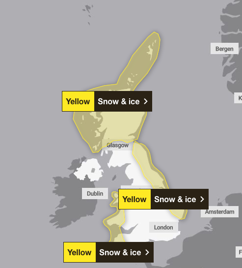
A number of severe weather warnings expired on Monday morning, but snow and ice warnings are still in force for much of Scotland, north of Glasgow, parts of Wales and the South West, and east England stretching up to the Scottish Borders.
The Met Office issued a yellow ice warning for Northern Ireland till 10am on Tuesday, while a fresh warning for snow and ice covers from just above Glasgow to the north of England from midnight until 11am on Tuesday.
Most of the current warnings are set to expire by 11am on Tuesday, but Scotland north of Glasgow will remain under a yellow warning until midnight, with the Met Office saying snow and ice is likely to bring further disruption.
A further 2-5cm of snow is likely to fall fairly widely, and there is a chance some areas could see a further 10-15cm, particularly over higher ground above 200 metres.
open image in gallery
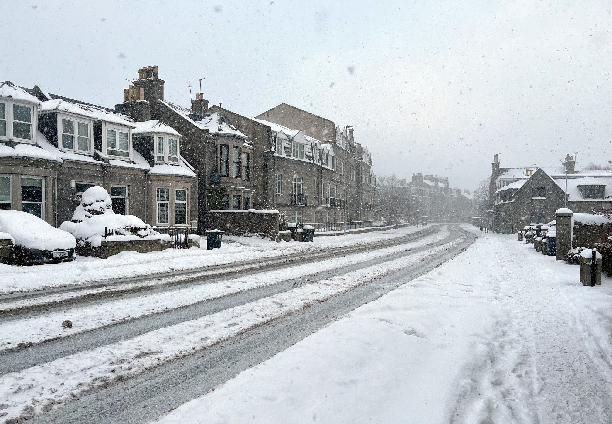
Scotland has faced the worst of the snowy weather (PA Wire)
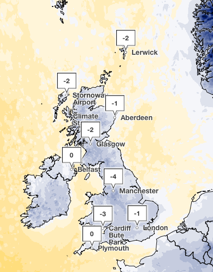
Temperatures overnight into Tuesday will continue to fall below freezing for much of the country, with the lowest temperatures accompanying snow possibly dipping to minus 12C, the Met Office said.
Met Office chief meteorologist, Matthew Lehnert, said: “The UK will continue to experience a range of winter weather hazards through this week, with low temperatures as well as snow showers and the risk of ice for many.
“A number of severe weather warnings have been issued and these are likely to be updated through the week so do keep up to date with the forecast.”
open image in gallery
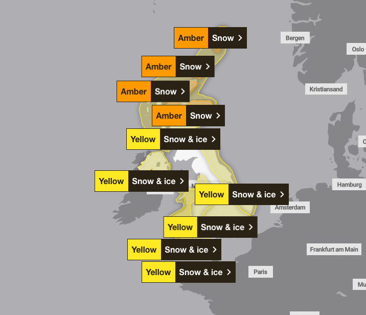
The UK was covered with weather warnings this morning (Met Office)
“Elsewhere in the UK, snow showers, ice and frost are expected at times, but milder air will make attempts to spread eastward from Tuesday. This will mean rain becomes more likely in the south, but there is also the possibility of more organised snow along the boundary of the mild and cold air masses. Strong winds could also be a feature later in the week.”
open image in gallery
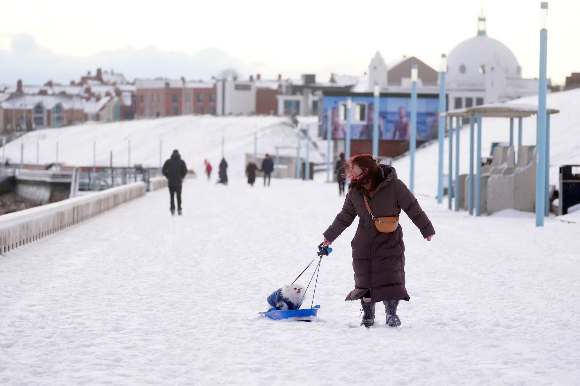
Temperatures will struggle to get above freezing as many people return to school or work after the festive period (PA Wire)
Travel disruption
Severe weather conditions have shut hundreds of schools across the UK on Monday as the Met Office warned travel could continue to be impacted in affected areas, with some rural parts becoming completely cut off.
Train services in northern Scotland will be disrupted until the end of the day on Tuesday, National Rail said.
Eurostar advised passengers travelling between London and the Netherlands to postpone their journey on Monday as services are unable to operate beyond Brussels due to the weather in the Netherlands.
All trains scheduled to depart from the Netherlands cannot run, a spokesperson added.
Loganair cancelled flights from Aberdeen and Inverness airports following heavy snowfall.
Liverpool John Lennon Airport posted on X on Monday morning to say the runway was closed due to wintry conditions and some flights were “subject to delay and there have been some cancellations”.
Both City of Derry Airport and Belfast International Airport said there had been a number of cancellations or delays on Monday.
The AA said there has been a 40 per cent spike in callouts compared to a typical Monday.
open image in gallery
Yellow snow and ice warnings will remain in place on Tuesday (Met Office)
Scottish transport secretary Fiona Hyslop said: “We’ve already seen challenging conditions and freezing temperatures, with more snow and ice on the way for the same areas.
“If you have to travel, then please ensure your vehicle is winter-ready and have a winter kit in your car.
“Follow Police Scotland travel advice. If you can delay your journey until the amber warning has expired, please do so.
“I’d also like to thank all the frontline staff such as gritter drivers, chainsaw gangs, police officers and many others who have been out working in dreadful conditions these past few days and over the next 48 hours.”
Health alerts in place
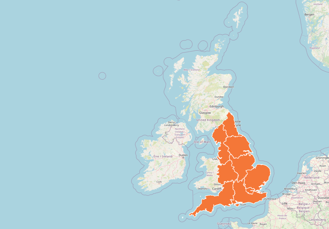
The UK Health Security Agency (UKHSA) has issued amber cold health alerts for all of England, as an early warning that adverse temperatures are likely to affect health and wellbeing, running until Friday.
The agency warns there could be significant impacts across health and social care services, including a rise in deaths, particularly among those aged 65 and over or with health conditions.
open image in gallery
Amber cold weather health alerts remain in place across the UK (UKHSA)
Dr Agostinho Sousa, head of extreme events and health protection at UKHSA, said: “As the colder weather sets in, it is vital to check in on friends, family and neighbours that are most vulnerable.
“The forecast temperatures can have a serious impact on the health of some people, leading to increased risk of heart attacks, strokes and chest infections, particularly for individuals over the age of 65 and those with pre-existing health conditions.”
Yellow snow and ice warnings will also be in place on Tuesday across Scotland until midnight, as well as the east coast and the southwest of England until 11am. Sleet is expected in the north on Tuesday morning, moving into the south in the evening, as the Met Office predicts a mixture of rain, sleet and snow will drift across the country with a risk of strong winds.
open image in gallery
The UK experienced sub-zero temperatures on Monday morning (Met Office)
Met Office weather forecast
Tuesday
Another cold day with a mixture of rain, sleet and snow which will move south-eastwards across Scotland and Northern Ireland, then later into parts of Wales and England, the Met Office said.
It will be drier in the south with sunny skies, before rain, sleet and snow moves in the evening.
There is a chance that a further spell of disruptive snow could affect central and northern Scotland later on Tuesday morning until early evening.
Tuesday will see a continuation of wintry showers at first across parts of Wales and south-west England, according to the Met Office.
Wednesday to Friday
Staying cold with frontal systems pushing in from the west. A mixture of rain, sleet and snow will move across the country at times with a risk of strong winds.
Further into the week there are signs that strong winds and heavy rain may bring additional hazards across the UK, the Met Office said.
Deputy chief meteorologist, Mike Silverstone, said: “While we’re confident an area of low pressure will move in from the west on Thursday and into Friday, the exact position of that low pressure is uncertain at this stage.
“The position is important as it will determine the type of severe weather different locations may experience.
“The most likely scenario at this stage is for low pressure to track near the south coast. Near and south of the low, heavy rain and strong winds are more likely, whilst snow could accumulate to the north as it encounters cold air. As confidence increases in the track of the low pressure, so will the detail of the weather impacts so it is important to stay up to date with the weather forecast through the week.”