Meteorologists have had their say on why the capital’s weather is so often different to the rest of the UK. It comes as Storm Goretti hits our shores, forcing The Met Office to issue a staggering nine weather warnings across parts of England, Wales, and the whole of Scotland, and Northern Island.
But the two weather experts we spoke to have slightly differing views as to why London has managed to give warnings the swerve. The first savant is Jim Dales of the British Weather Services.
He thinks part of the reason why is because the nature of the city, London is an ‘urban heat island’, which forces temperatures to be ever so slightly warmer than the surrounding areas. But he also added that our position on the map plays a significant part too.
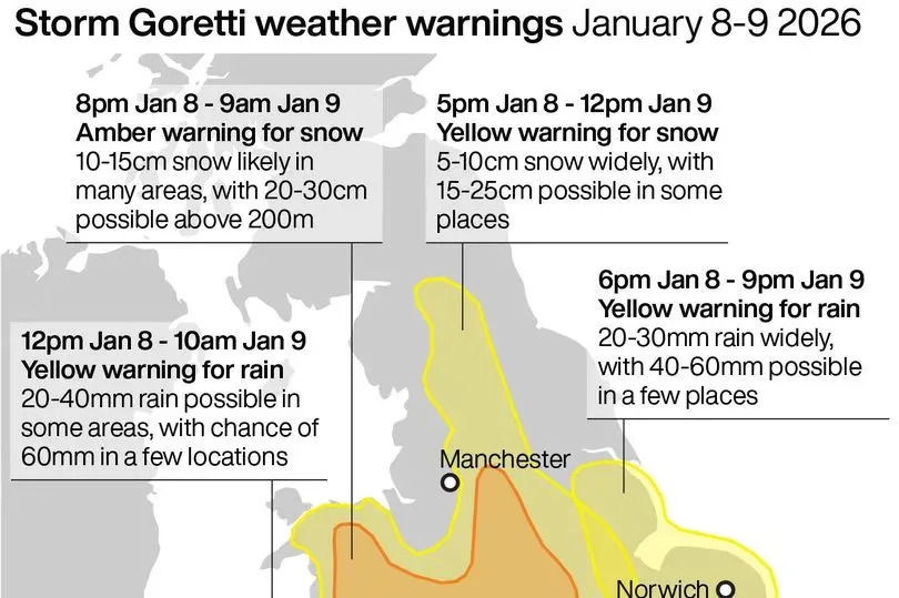
A graphic detailing the weather warnings covering England -Credit:PA
Jim said: “London is an urban heat island even in the winter time, it is normally a degree or so less cold. It’s not always the case though, [but] in this case in the snow scenario, [as to] why there’s no snow for London, that is more down to the latitude than it is anything else.
“Latitude plus the fact it’s an urban heat island. You’ve also got a fairly close proximity to the north sea and to the south to the Channel, so a little more mildness coming off those seas depending on wind direction.”
However he ruled out anything to do with greenhouse gases playing a role in us not being slapped with a weather warning. “I don’t think it’s anything to do with pollution, as the levels have got better not worse,” he said. “London will be slightly more polluted than other areas, but since ULEZ came in that’s going in the right direction.”
The nature of a city being heavily concreted is another contributing factor. He said: “It is also heavily concreted so any sunshine that comes in the daytime, you get that additional warmth of the concrete warming up that little bit more.”
MyLondon also spoke to Met Office weather forecaster Craig Snell. He has a slightly differing take as to why London has zero weather warnings.
He clarified warnings are issued to places which are likely to see disruption, and not zero snow. He said: “Firstly, our warning areas highlight where we are likely to see the most disruption and impacts from the snow and don’t necessarily mean that is the only area which will see snow in the next day or so.”
But another reason there is no snow warning hitting the capital is due to the types of air sweeping across the nation. Craig added: “The reason why the snow warning stops just to the north and west of London is all down to the battle between the cold air currently across the UK and milder air trying to come in from the Atlantic.”
However he didn’t rule out the possibility of snow entirely, with the possibility of a change in the forecast. He said: “Our current thoughts are that the slightly milder air will make inroads across southern counties which will generally mean precipitation will fall mainly as rain in London. Saying that we could see some sleet and wet snow fall across London with the higher ground across the north and west of London probably most prone to this, but any accumulations are expected to be slight and shouldn’t cause too many impacts. However, this is a developing weather system so some changes in the forecast are possible between now and late tomorrow, so best advice is to stay up to date with the latest forecast.”
Looking for more from MyLondon? Subscribe to our daily newsletters here for the latest and greatest updates from across London.