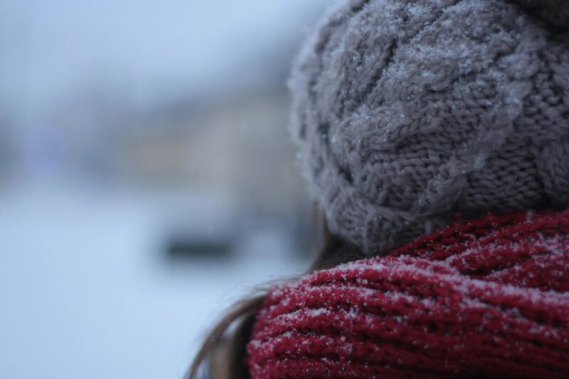
 Extreme cold is hitting the U.S. People are bundling up! Find out if the Arctic air will affect you. Image via Demeter Attila/ Pexels.
Arctic air surging south in the United States
A blast of Arctic air is moving across the United States, with some of the coldest temperatures expected Friday morning. A strong cold front has been moving across the lower 48 of the United States the past few days with, Canadian high pressure following along in its wake. As this high pressure dives south, the Arctic air also dives south. It will bring frigid conditions across the United States, particularly the southern and eastern U.S.
Freezing temperatures … in Florida?
Forecasters expect the Arctic air to impact many areas across the south and east, including as far south as south-central Florida! The Miami National Weather Service Office issued a Freeze Warning for Friday morning. The warning is mainly for inland areas where temperatures are expected to fall below freezing.
While south Florida can experience cold temperatures relative to their normal morning temperatures – which are in the low 50s this time of year – it has been a while since chilly weather has prompted a warning. In fact, the last time the Miami Weather Service issued a Freeze Warning was in January of 2022. (In October 2024, the National Weather Service consolidated and simplified its cold weather information. Prior to this a Freeze Warning was called a Hard Freeze Warning. You can find more information on the simplified weather information from the NWS here.)
While a Freeze Warning does warn about freezing temperatures, it is mainly used for the agricultural industry. Freeze Watches and Warnings are meant to let growers and producers of food – particularly sensitive plants (including Florida citrus) – know that it’s time to protect their crops from the cold temperatures that could damage or kill or them.
Temps and wind chills for Florida
For human protection, the National Weather Service issues Cold Weather Advisories and Extreme Cold Watches and Warnings. The NWS issues Cold Weather Advisories when dangerously cold conditions are forecast. Those advisories have been issued for most of south Florida for Friday morning. Wind chill values (what it will feel like when the wind is factored into the air temperature) should be as low as 26-30 degrees Fahrenheit (-3 to -1 degrees Celsius).
For some across North America, this is a typical winter day, but it’s important to remember that impacts from temperature are relative. In a place like south Florida where temperatures are warmer, the criteria for “dangerous” cold is very different than those to the north. It is always important to take every advisory issued by your National Weather Service office seriously.
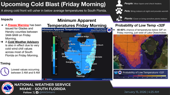 For the first time in 3 years, a Freeze Warning has been issued for south Florida. The cold temperatures will arrive Friday morning. Image via NWS Miami.
Staying safe in extreme cold
If extreme cold is forecast for your location, make sure you are protecting yourself and your loved ones. As soon as you know extreme cold is in the forecast, if you are able, adjust the time you will spend outside. The coldest part of the day is typically the morning, so avoid being outside at that time. If you have to be outside, bundle up! Dress in layers and cover any exposed areas to the outside air with hats and gloves.
Wind chill is an important factor
Know the risk from the wind. Wind chill is how much colder it feels due to wind. It’s based on how much heat is lost from any exposed skin from the wind. The stronger the wind, the more heat it draws away from your body, which will cool off your skin temperature, then your internal body temperature. As your body temperature starts to decrease, your risk of hypothermia increases.
Hypothermia is a serious health condition when your body temperature drops below 95 degrees Fahrenheit (35 degrees Celsius). Warnings signs that someone is suffering from hypothermia are shivering, confusion, difficulty speaking, stiff muscles and drowsiness. And, in serious cases, it can result in a lack of consciousness.
If you suspect someone has hypothermia and they have passed out, immediately call 911! Even if that person hasn’t passed out, call for medical assistance and start to warm them up from the center out. You can do this by lying next to them, covering both yourself and the other person with thick blankets to slowly warm their body temperature. The warmer you are, the more body heat you can transfer to that person until help arrives.
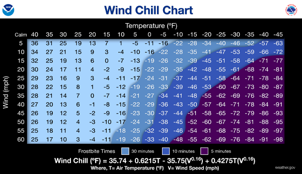 A chart that will help you determine what the wind chill is based on temperature and wind speed. Image via National Weather Service.
Arctic air particularly hard on the vulnerable
Cold impacts everyone differently, but there are particular groups of people that are especially vulnerable to the risks of cold weather. These include the very young, including newborns who can’t regulate their own body heat yet, as well as the elderly. People with chronic illness are also more susceptible to cold weather illness.
In addition, people who spend most of their time outside are at risk. This includes outdoor workers, but also the unhoused community and people who don’t have a regular place to stay. Underserved or impoverished communities who may not be able to afford to run their heat as often are also as risk from the cold. So make sure you are checking on your neighbors and community members so they can stay safe during an Arctic outbreak.
Stay up to date with your local forecast with your local weather service office. In the top left, enter your location for your up-to-date forecast.
Bottom line: Arctic air is diving south across the United States impacting millions of people, even as far south as south Florida! Another cold blast in on the way for early next week.
Read more: U.S. winter weather outlook and how La Niña will factor in
Rachel Duensing
View Articles
About the Author:
Rachel Duensing is a Certified Broadcast Meteorologist by the American Meteorological Society and is currently a meteorologist and climate reporter at CBS17 in Raleigh, North Carolina. Rachel has previously worked in Fort Myers, Florida and Carterville, Illinois. In addition to daily weather, she has covered tornado outbreaks, hurricanes, and extreme heat and cold.
Rachel received her Bachelor of Science degree in Meteorology and Digital Media from Valparaiso University in Valparaiso, Indiana. While at Valpo, she was a member of the Valparaiso University Storm Intercept Team, and along with professors and classmates, chased tornadoes and severe weather across the United State’s Great Plains and Midwest.
Rachel grew up outside Chester, Illinois, a small town in the southern end of the state (nowhere near Chicago!). When she was only 10 years old, Rachel learned about weather in science class, and when those lessons were followed up by a tornado outbreak outside her town, she took it as a sign and has been in love with weather ever since!
When not forecasting the weather or reporting on weather and climate, Rachel spends her time volunteering at a local cat shelter and watching hockey with her husband.