Storm Ingrid has hit parts of the UK as Cornwall and Devon was battered by strong winds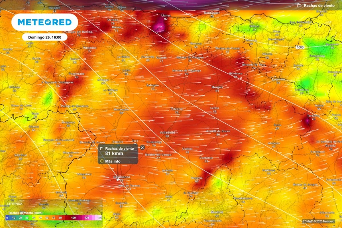
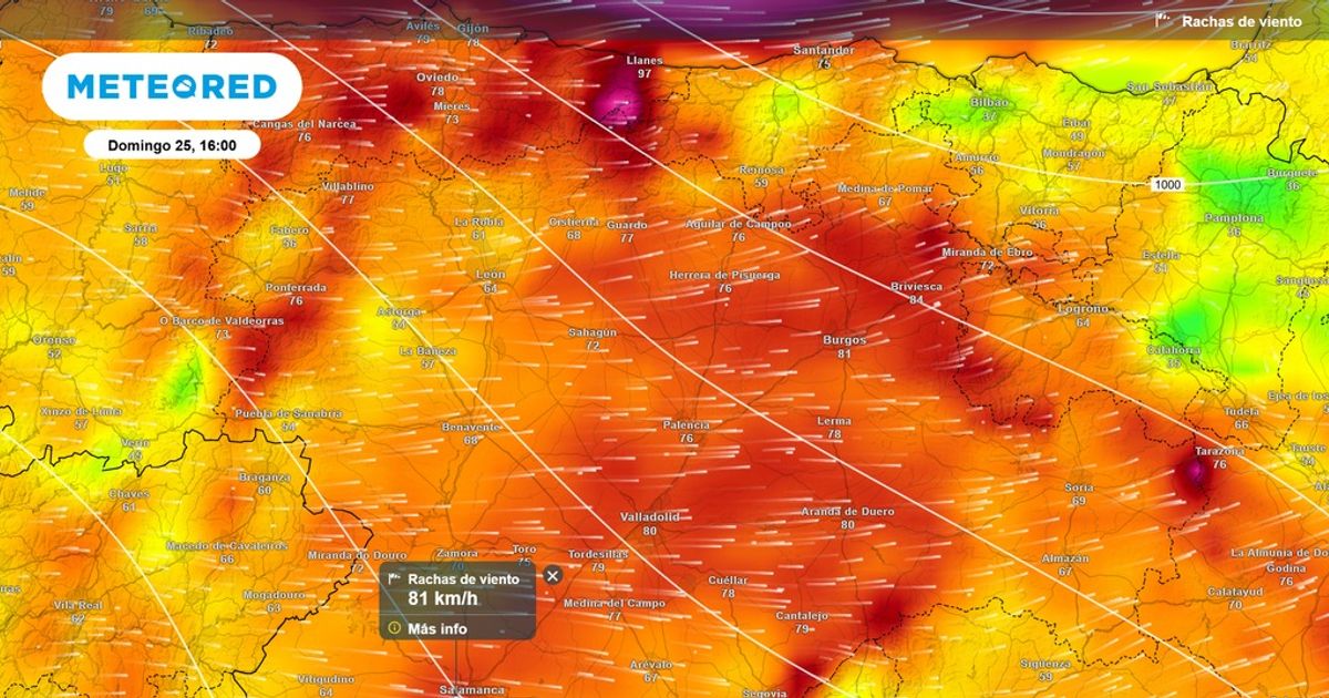
Strong winds are expected across Spain as Storm Ingrid continues to bring disruptive weather to Europe(Image: Meteored España)
Parts of mainland Spain and the Canary Islands have been hit slapped with red, amber and yellow alerts for wind, snow, storm, rain and coastal warnings as Storm Ingrid continues to bring chaos to parts of Europe.
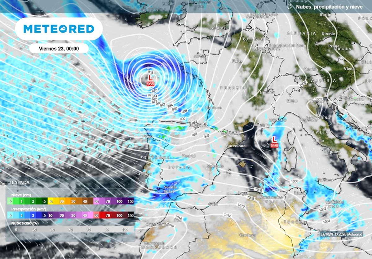
Storm Ingrid – which was named by the Portuguese weather service Instituto Português do Mar e da Atmosfera (IPMA) – has been bringing severe weather to Spain and Portugal over the last few days, with the worst of the weather experienced on Friday (January 23).
Issued by Spain’s weather agency AEMET (State Meteorological Agency), red coastal warnings are set to come into force on Sunday (January 25) across parts of north west Spain (A Coruna and Cantabria) as wind gusts are set to reach 88kmh. Yellow wind warnings cover large parts of Spain including Catalonia, Navarre, Murcia and Valencia.
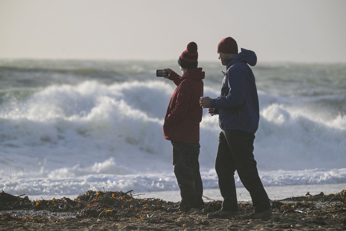
Storm Ingrid brought disruptive weather to parts of south west England this week(Image: Getty Images)
Most of these warnings continue into Monday (January 26), including yellow and amber snow warnings across parts of Spain, and wind alerts in place across most of the Balearic Island on Sunday and Monday (January 26). There is one storm warning in Minorca.
Spanish news site Majorca Daily Bulletin reported that Storm Ingrid is causing serious transport problems, especially when it comes to good vehicles and it could pose a threat to food supplies to the Balearic Islands. And Spanish weather site Meteored España warned that Storm Ingrid will continue to bring ‘adverse’ conditions to mainland Spain.
Warning that wind gusts are set to increase 80kmh, Meteored España said: “The presence of cold air associated with the system is favoring the appearance of snowfall in large areas of the northern half of the peninsula , with relatively low elevations and generating numerous incidents.
“Adding to this wintry context is the wind, another of the most prominent elements of the storm. The intense pressure differences generated by Ingrid are producing very strong gusts in numerous regions, increasing the feeling of the storm and the risk of complications.
“That westerly and northwesterly wind will be the main feature of Sunday in Zamora, Salamanca, and Burgos. From the early hours of the morning and throughout the day, moderate sustained winds will be noticeable , with speeds that will frequently exceed 40 kmh.”
Storm Ingrid was named by Portugal’s weather agency(Image: Meteored España)
People in the affected areas are being urged to take extra precautions due to the weather. Meteored España continued: “Given the windy conditions, it is essential to take extra precautions and adopt a series of preventative measures to minimize potential incidents.
“It is recommended to properly secure any objects that could be moved by the wind, such as flowerpots, patio furniture, awnings, or loose items on balconies and rooftops. These objects can become a hazard if lifted by strong gusts.”
As for the Canary Islands, amber coastal warnings are in force on Sunday in Fuerteventura and Lanzarote, with a less severe yellow coastal warning in force across La Gomera, Tenerife, La Palma and El Hierro the same day. The Canary Islands are currently in a state of pre-alert due to the weather conditions.
An alert on the Gobierno de Canarias (Canarian government) reads: “The Government of the Canary Islands, through the Directorate General of Emergencies, has updated the alert status for coastal phenomena across the archipelago, effective from 6:00 a.m. tomorrow, Saturday, January 24.
“This decision is based on information provided by the State Meteorological Agency and other available sources, and is in accordance with the Canary Islands Specific Emergency Plan for Risks of Adverse Meteorological Phenomena (PEFMA).”
And in the UK, downpours and high winds are likely to continue after Storm Ingrid wreaked havoc in the South West and washed away part of a historic pier in Devon. A yellow warning remains in place for Somerset, Devon and Cornwall and much of south Wales until 10pm on Saturday, while separate warnings in Northern Ireland and Scotland will run until 9am on Sunday.
Met Office meteorologist Tom Morgan said: “It’s been a contrasting picture depending on where you live, but if you haven’t seen rain so far this weekend, the likelihood is that you will see some tonight or through Sunday. Generally, it’s a bit of a mixed picture through the next few days.
“We’ve got a strong jet stream powering across the north Atlantic, fuelled by a big temperature contrast across north America. As it comes across the Atlantic, it gets stormy across the UK. So, unfortunately, the weather is looking very much unsettled right the way across the coming week.”