Home » United Kingdom Travel News » United Kingdom Faces Major Rainstorm with Flooding Risks and Travel Disruptions as Weather Warning Impacting South and Mid-Wales Sparks Urgent Public Advisory
Published on
January 26, 2026

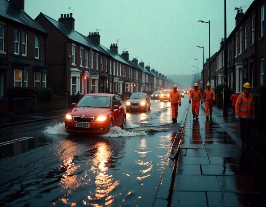
The United Kingdom is facing a powerful rainstorm that has triggered widespread flooding alerts and severe travel disruptions across South and Mid-Wales. From 15:00 GMT on Monday until 12:00 GMT on Tuesday, the region is expected to receive significant rainfall, with some areas potentially experiencing up to 80mm of rain. This deluge falls on already saturated ground, heightening the risk of flooding in low-lying areas, disrupting daily life, and creating hazardous travel conditions. The storm is set to affect major roads, public transport services, and local infrastructure, forcing authorities to issue urgent warnings for commuters and residents. Given the severity of the storm, it is critical for people to stay informed, prepare emergency kits, and follow safety measures to mitigate the impact of the storm’s relentless downpour.
Yellow Weather Warning for Rain Issued in South and Mid-Wales: Potential Flooding and Travel Disruptions Expected
A yellow weather warning has been issued for much of south and mid-Wales, as heavy rainfall threatens to cause significant disruptions and flooding across the region. The warning, which will be in effect from 15:00 GMT on Monday until 12:00 GMT on Tuesday, has raised concerns about the risk of severe flooding and possible travel delays, particularly for those traveling by road or using public transport.
According to the Met Office, the region can expect rainfall amounts ranging from 20mm (0.8in) to 30mm (1.2in), with some areas, such as Bannau Brycheiniog in the Brecon Beacons, potentially receiving as much as 80mm (3.2in) of rain. With the ground already saturated from previous downpours, this additional rainfall is expected to exacerbate flooding conditions, particularly in areas already prone to waterlogging.
Flooding Risks and Impact on Local Communities
As the rain continues to fall, the risk of flooding is heightened, especially for homes, businesses, and roads located in low-lying or flood-prone areas. The persistent rain could overwhelm drainage systems, resulting in localized flooding that may disrupt daily life. The public is advised to remain vigilant, particularly during the Monday evening and Tuesday morning commute times, when rainfall is expected to be at its heaviest.
Advertisement
Advertisement
Advertisement
Advertisement
In anticipation of potential disruptions, the Met Office has urged residents living in flood-risk areas to take precautionary measures. Homeowners are encouraged to check their flood plans, ensuring they have essential items ready, such as flood barriers, a torch, a fully charged mobile phone, and extra batteries. It’s also advisable to have an emergency kit prepared, including food, water, and other necessary supplies in case of power outages or emergency evacuations.
Travel Disruptions: What Commuters Should Know
The yellow warning also highlights the significant risk of travel disruptions due to heavy rainfall and flooding. With the possibility of flooding on major roads and local routes, travelers are advised to plan ahead and allow for additional travel time. Local authorities, including Traffic Wales, have issued safety guidelines for motorists, urging drivers to take extra care when driving in poor visibility and wet conditions.
Advertisement
Advertisement
Motorists are advised to slow down and maintain a safe distance from other vehicles to avoid accidents. If encountering floodwater on the road, drivers should seek alternative routes and avoid driving through water, as its depth may not be immediately clear. In some cases, flooded roads may be closed or impassable, causing further delays and detours.
For commuters relying on public transportation, there may also be delays or cancellations due to adverse weather conditions. Bus and rail services in affected areas are likely to be disrupted, with potential delays caused by flooded tracks or roads. Travelers are encouraged to check the status of their services and allow extra time for their journeys.
Local Government Response and Preparedness
In response to the warning, local authorities in affected areas are working to ensure that flood prevention measures are in place, including the monitoring of river levels and the clearance of blocked drains. Emergency teams are on standby to assist with flood management and help with evacuations if necessary. Local councils are also advising residents to avoid non-essential travel, especially during peak rainfall periods.
The counties affected by the warning include Blaenau Gwent, Bridgend, Caerphilly, Cardiff, Carmarthenshire, Ceredigion, Merthyr Tydfil, Monmouthshire, Neath Port Talbot, Newport, Pembrokeshire, Powys, Rhondda Cynon Taf, Swansea, Torfaen, and Vale of Glamorgan. These areas are expected to experience the heaviest rainfall, with some regions seeing the potential for significant flooding.
Preparing for Power Outages
In addition to flood risks, there is also the potential for power cuts due to the combination of heavy rain and strong winds. With the possibility of fallen trees or debris affecting power lines, residents are advised to be prepared for potential power outages. The Met Office has recommended that people gather essential items such as torches, mobile phone chargers, and backup batteries to ensure they are equipped in the event of a power failure.
Power companies are also on alert and will work to restore services as quickly as possible if outages occur. However, given the widespread nature of the storm, it may take longer than usual for power to be fully restored in some areas.
Community Safety: Stay Informed
As the storm approaches, it is crucial for residents and travelers in affected areas to stay informed about the weather conditions and any changes to local transport and flood alerts. The Met Office will continue to monitor the situation and issue updates as necessary. Local news outlets and emergency services will provide timely information regarding closures, delays, and safety precautions.
For those living in areas at risk of flooding, it is especially important to remain prepared and remain in close communication with local authorities. While the heavy rainfall is expected to subside by Tuesday afternoon, the immediate priority is ensuring the safety of all residents and travelers across the region.
The United Kingdom is preparing for a severe rainstorm, bringing heavy rainfall and flooding risks to South and Mid-Wales. The storm, expected from Monday afternoon until Tuesday midday, could cause significant travel disruptions and impact local infrastructure.
The heavy rain in south and mid-Wales presents significant risks for local communities, particularly concerning flooding and disruptions to travel. With up to 80mm of rain expected in some areas, residents are urged to prepare for potential flooding, power outages, and travel delays. As the storm continues, staying informed and following safety guidelines will be essential for minimizing disruptions and ensuring the safety of all affected.