
Inconsistencies in Israel’s latest evacuation notice for Gazapublished at 12:10 British Summer Time
12:10 BST
 Benedict Garman
BBC Verify senior journalist
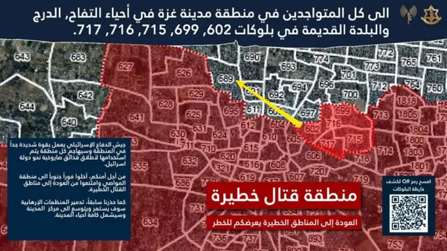 Image source, IDF
A new notice was published by the Israeli military last night, warning people to evacuate additional areas of Gaza City.
The Israel Defense Forces (IDF) has divided Gaza into numbered blocks and when it issues warnings for certain areas they are shaded red – it often says it will operate with “extreme force” in these zones.
The notices advise people to leave for their “safety” and to “refrain from returning”. They usually precede air strikes or other military action.
We’ve been logging and mapping each of them, and we sometimes identify inconsistencies or a lack of clarity that could lead to confusion for those relying on them.
The latest, external is a good example of this. The text specifies five blocks in Gaza City. Two of them – 602 and 699 – have not been subject to notices before.
They are coloured red in the map that goes with the notice. But the IDF has an official online map which does not have them shaded – this is where people are directed to via QR codes on leaflets dropped from the air.
Conversely, blocks 603 and 611 are not pictured as red zones in the latest notice, but both were warned to evacuate at the end of June, and remain red on the map on the IDF’s website.
This suggests they continue to be “dangerous combat zones”. Anyone relying on the latest notice wouldn’t necessarily know that.
We’ve put these points to the IDF and will update if we hear back.