
Four counties in England could escape a fourth heatwave arriving in August, with temperatures set to peak at 35C Four counties in England could escape a fourth heatwave arriving in August
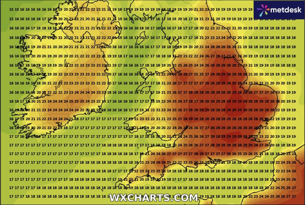
Large parts of England could be set to swelter in August with the arrival of a fourth heatwave of the summer.
The second full week of the month is seeing weather maps from WX Charts turn red.
Temperatures must reach at least 25C for three consecutive days for most parts of England in order to be officially classed as a heatwave by the Met Office, while it is 28C for London and parts of the South East.
READ MORE: 20 counties in England set to sizzle in heatwave with temperatures reaching 31C
Get breaking news on BirminghamLive WhatsApp, click the link to join
While the heatwave threshold is set to be passed in dozens of counties across the Midlands, East Anglia and the South East, four counties in England could escape the heat, according to wxcharts.com.
The mercury is set to turn up a notch or two from Sunday, August 10, to Thursday, August 14.
 Four counties in England could escape a five-day heatwave arriving in August(Image: WX Charts)
Within that period, counties in England could experience highs of 35C, with the hottest widespread temperatures forecast to arrive on Wednesday, August 13.
However four counties are set to escape meeting the heatwave threshold during that period, which are: Cumbria, Durham, Tyne & Wear and Northumberland.
Cornwall, Lancashire, Cheshire and Merseyside could also escape meeting a full five-day heatwave, according to WX Charts.
In its long-range forecast from August 5 to 14, the Met Office said: “An unseasonably deep area of low pressure clearing to the east, may bring widely windy and wet weather at first, especially for the north or northeast of the UK.
“Following this will be a breezy but sunny day for most with a risk of showers in the north.
“The forecast around this is rather uncertain, however, and it is also possible that it will clear more quickly.
“Following this, a continuation of the broadly changeable pattern is expected, with spells of rain or showers, some drier, brighter interludes and temperatures mainly near average.
“As we move towards mid-month, there is an increased chance of high pressure becoming more dominant, leading to drier, warmer and more settled conditions becoming more widespread.”