Rapid warming is underway from southern to western and central Europe as a Heat Dome strengthens over the continent. A new, long-lasting heatwave is forecast to engulf much of Europe, with locally challenging August temperatures breaking historical records. Over the next 10 days, a powerful ridge will push temps into the low 40s across many European countries.
As the early August model guidance hinted, a significant heatwave is rapidly developing across the southern half of Europe, expanding northward. After a temporary mid-summer overheating pause, peak afternoon temperatures return to the low 40s °C over France, the central Balkans, and Italy.
Extreme, scorching heat will also worsen ongoing drought conditions across Iberia, central, southern, and partly western Europe, where recent devastating and historic wildfires have been ongoing in south France, the west Iberian peninsula, Greece, and Turkey.
A major Heat Dome is building up over a large part of Europe this week and will remain strong throughout the new week, lasting into mid-August. Over time, the excessive heat will spread north and east, reaching the UK and Benelux, to Slovakia, Ukraine, and Poland on the east. The following video shares the evolution of weather patterns over the next two weeks.
The mid-range trends suggest a long-lasting, intense heatwave will develop and affect many countries. Stable hot weather is significantly and rapidly increasing temperatures, leading to temperatures of around 40 °C again over France, Italy, the central Balkans, and Spain and Portugal, where extreme heat has already been baking the peninsula since early this month.
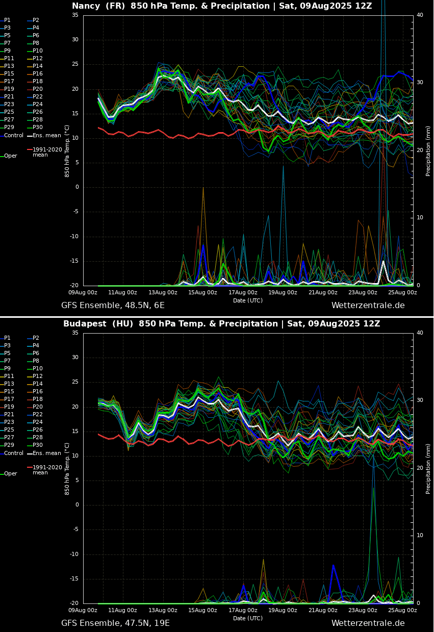
Let’s quickly check the general trends with the meteogram charts for Nancy, France (upper), and Budapest, Hungary (bottom). We can see that the heatwave has already brought well-above-normal temperatures. It also intensifies over France after Tuesday, August 12th, and extends until mid-August.
Central and Eastern Europe will also see a rapid temperature increase throughout mid-week as the heat dome expands east. The heat wave will also be long-lasting.
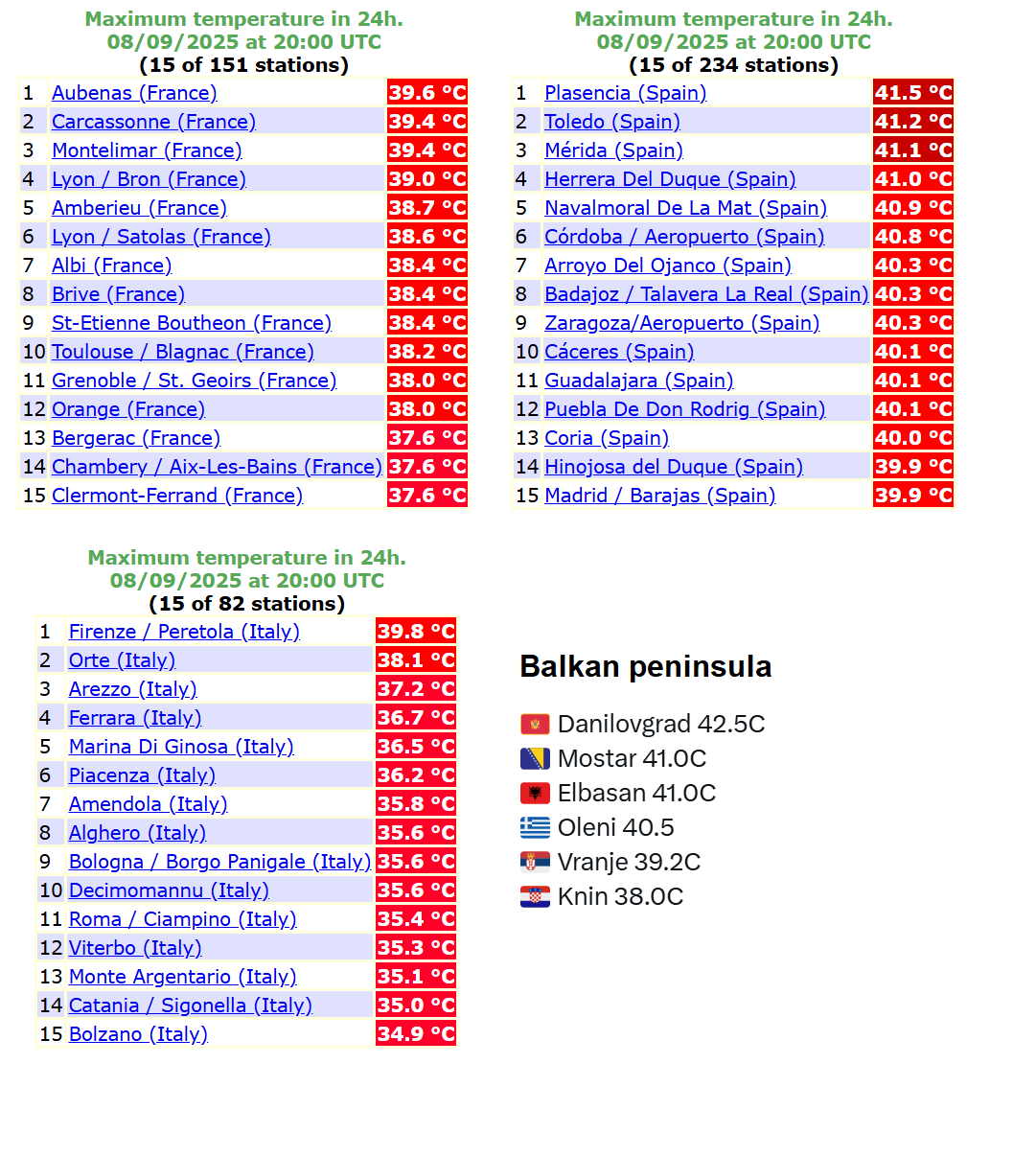
Heatwave strengthening; Saturday brings Iberia and the central Balkans to 42 °C, near 40s in France and Italy
On Saturday, the heat significantly intensified from the Mediterranean region and the Iberian peninsula northwards, expanding into France, Italy, and the Balkans. Afternoon temperatures reached nearly 40 °C in southern France, the Po Valley in Northern Italy, and Greece.
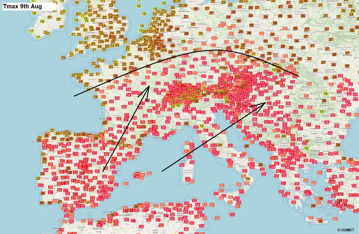
Spain pushed up to 42 °C again, similar to the whole week. The central Balkans has also rapidly heated up, with 40-42 °C observed over Bosnia, Albania, and North Macedonia.
The much higher temperatures, back into the mid-30s, have reached central France, southern Germany, the Alpine region, Hungary, and Slovakia. So, there has been quite a significant and rapid warming up compared to just a few days ago. The scorching heat will intensify more on Sunday and spread further north and east.
Again, the intense heatwave typically results from developing the heat dome feature aloft. Let’s examine this large-scale feature and why understanding its behavior is essential.
What is a Heat Dome?
When significant and historic record-breaking heatwaves occurred in Europe, the United States, and Canada in the past, the Heat Dome was a contributing factor. The heat dome is usually the dominant feature of summer weather patterns on both continents.
We refer to this phenomenon as a heat dome when extremely high temperatures develop. Here’s how it works and why understanding it on a broader scale is essential.
The upper-level ridge pattern, or very warm air mass in the higher altitudes, also known as the Upper High (or blocking High), usually forms the heat dome. This weather pattern brings high and sometimes record-breaking temperatures to the region underneath.
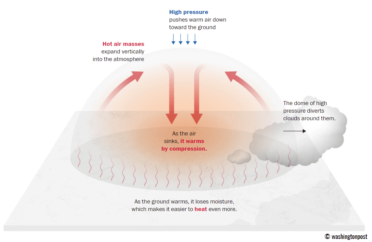
This term is used when a broad area of high-pressure air parks over a large portion of the continent. If the event is remarkably stable and extreme, it usually lasts several days or weeks.
The heat dome works like a lid on a pot. The extensive dome traps warm air at all levels underneath, with layers sinking toward the ground. Therefore, the air mass becomes anomalously warm at the lowest elevations and extremely hot near the surface.
How does a heat dome impact the life underneath?
Excessive heat in heat domes can significantly impact human health and be dangerous to particularly vulnerable populations, such as elderly individuals, children, and those with pre-existing health conditions that can be worsened by extreme heat.
Due to prolonged exposure to high temperatures, construction workers, farmers, and agricultural workers who work outdoors for long hours are at increased risk of heat-related illnesses. People living in poverty are also more susceptible to the fatalities of heat domes, as their houses are often built with heat-trapping surfaces such as concrete and asbestos.
Heat exhaustion occurs upon exposure to high temperatures for extended periods. It leads to dehydration, dizziness, and, in more severe cases, heat exhaustion can progress to heat stroke.
High relative humidity during a heatwave can also significantly affect the body. For this reason, we use a Heat Index to represent the natural feel of scorching hot temperatures and high humidity. These graphics illustrate the natural relationship between temperature and humidity.
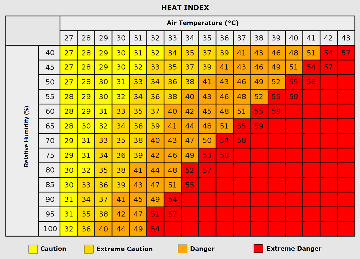
When the air mass has a temperature around +35 °C, humidity below 60 percent is much less challenging than when the humidity is very high, e.g., above 80 %. Thus, the actual feel temperature would be near 50 degrees Celsius.
Heat waves have also been associated with increased rates of heart attacks, strokes, and respiratory illnesses.
Our additional article, “Health risks during a heatwave and sweltering hot weather,” provides further details on the health risks.
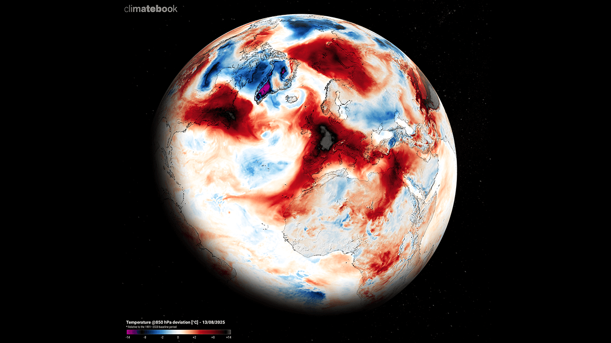
The Heat Dome dominates a large part of the European continent through mid-August, igniting an extreme, potentially historic heatwave in some regions
As the weekend ends, the Heat Dome will gradually continue strengthening from the southwestern into western and central Europe. The core of the blocking ridge aloft will be centered over France, expanded towards Ireland and the UK, and the northern Balkans on the other side.
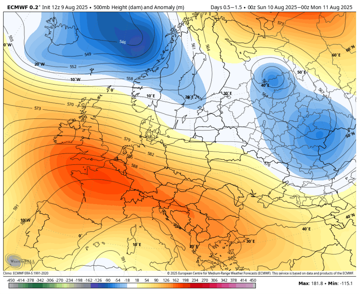
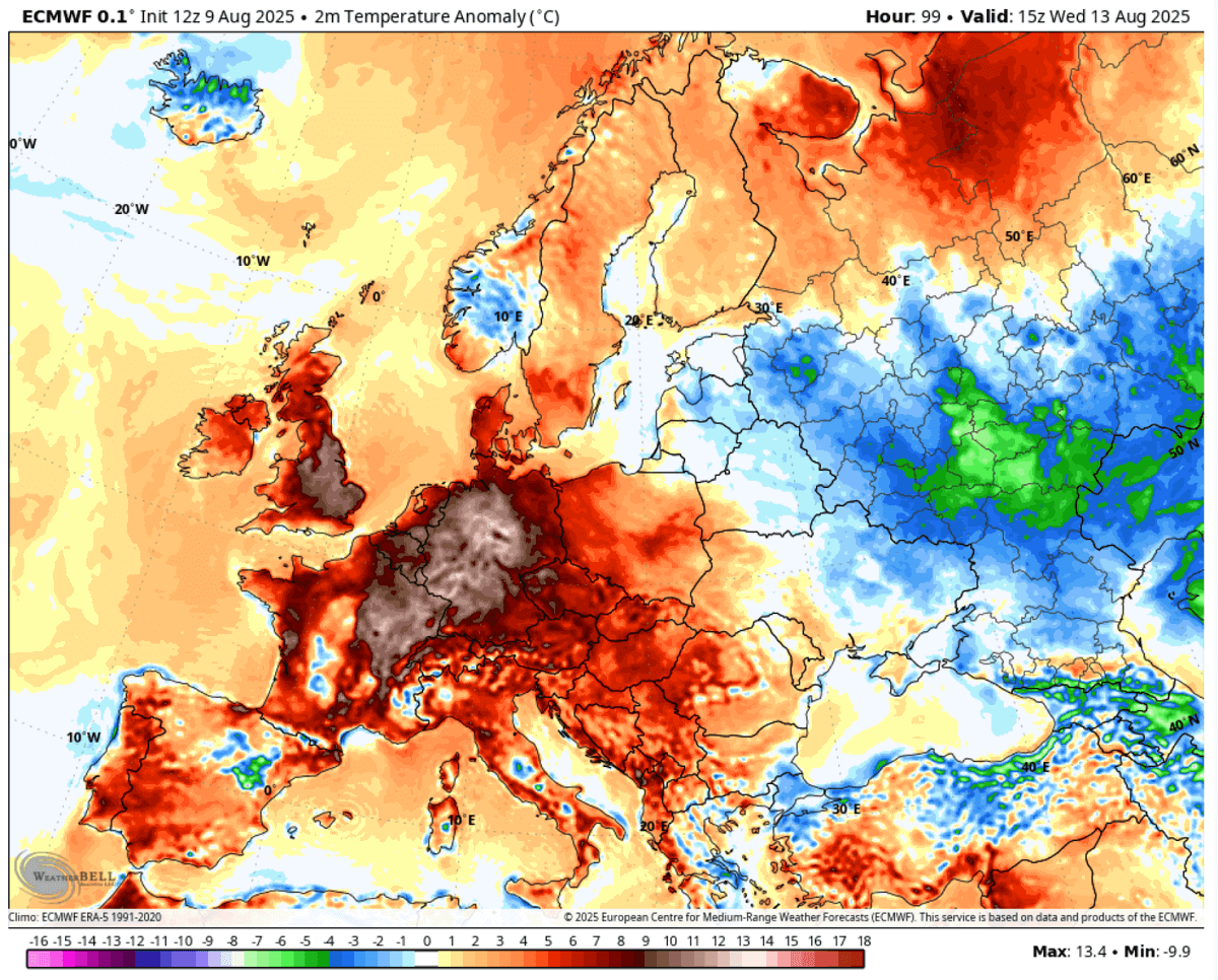
The first half of the week will bring the most anomalous temperatures from France to the UK, Benelux, Germany, and the Alpine region. Temperatures will be around 10 °C above normal in these 5 days. Starting Monday, the strengthening of the heat dome will release a significantly warm air mass plume into western Europe.
Temperatures will be 10 °C or even higher than normal daily. In France, the temperature anomaly will reach around 15 °C, above normal for mid-August.
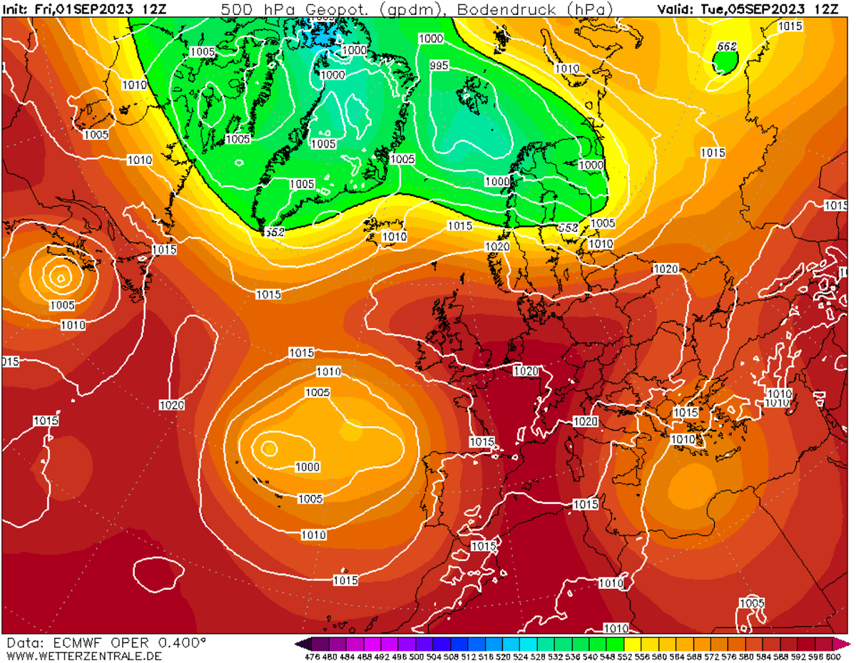
After mid-week, the heat dome’s center will mature, expand, and shift further north and east, therefore reaching towards Eastern Europe.
The large block will build up an Omega pattern, with its core expanding across the central part of the continent. One significant low will be over Russia, and the other will be over the North Atlantic.
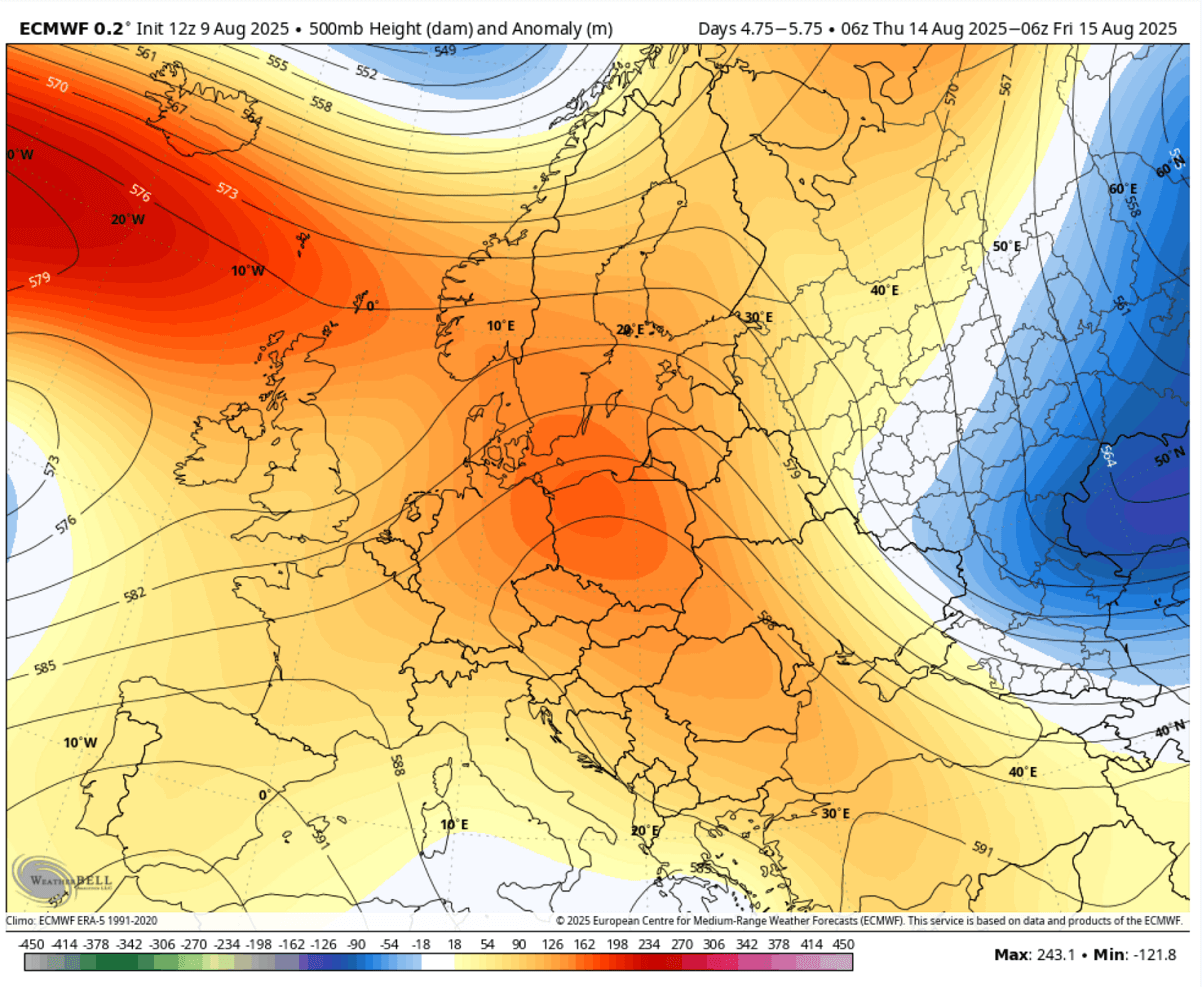
This is a textbook scenario for extreme, potentially historic heat beneath the dome. This will also allow the temperature to climb higher in this part of Europe, while central Europe has seen no change since the beginning of the week. Extreme heat will bring a long-lasting heatwave.
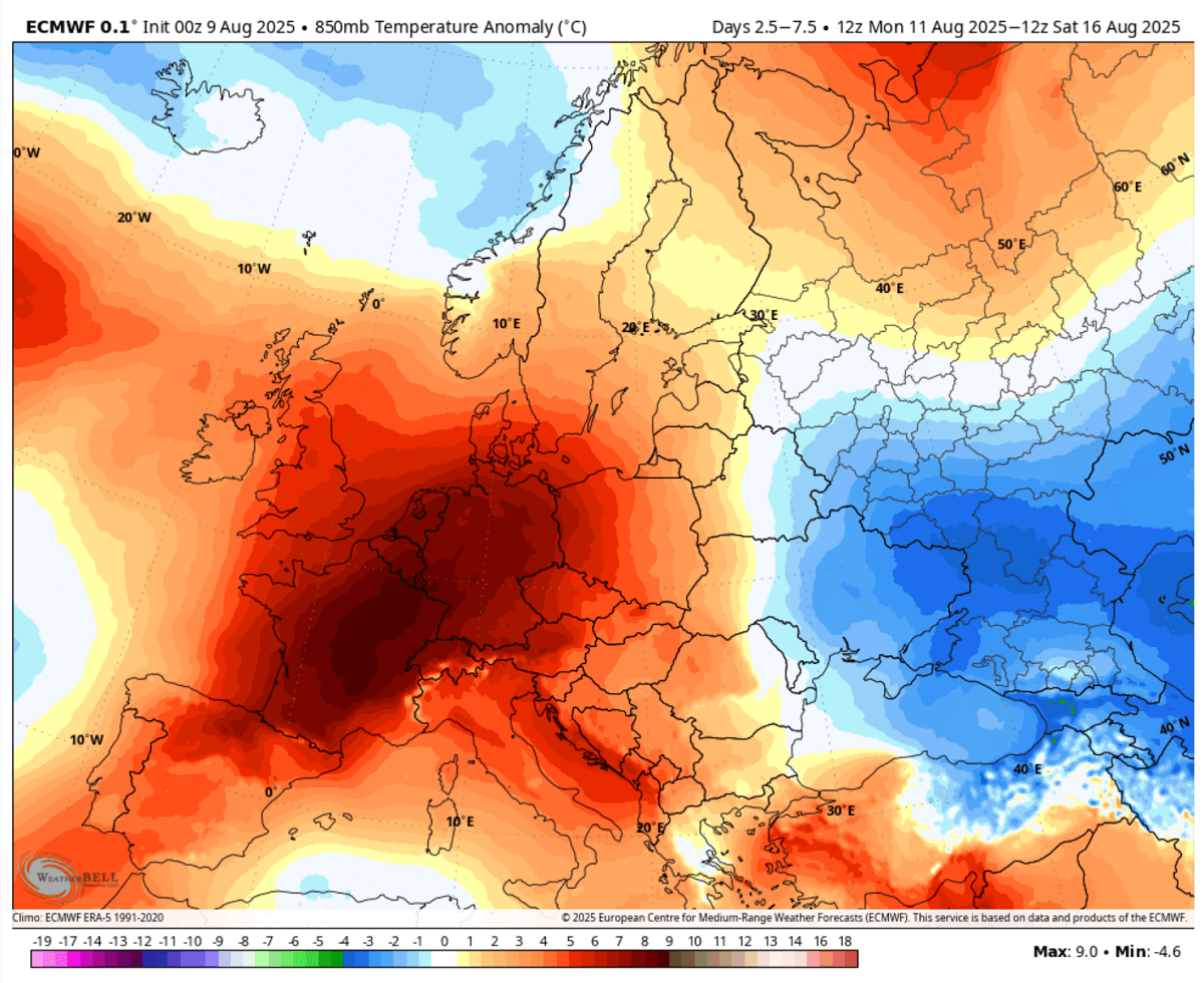
The 5-day period from Wednesday through Sunday next weekend indicated the most anomalous air mass over France, Germany, central Europe, Poland, the Baltic region, and even southern Scandinavia again. This is right under the core of the dome of heat aloft. Temperatures will be 8-10 °C above the average in this period, even more on some days.
The lowlands will experience extreme temperatures for multiple days, becoming dangerously excessive heat.
The following chart indicates the 2m temperature anomaly on Wednesday, indicating that a large part of western and central Europe will be baking under extremely high temperatures.
An extended period of 35-40 °C or even higher will also significantly increase the wildfire threat and exacerbate the drought conditions.
France, Portugal, and Spain could warm up to near 44 °C, upper 30s to low 40s over Italy, the Balkans, western Germany, and Benelux
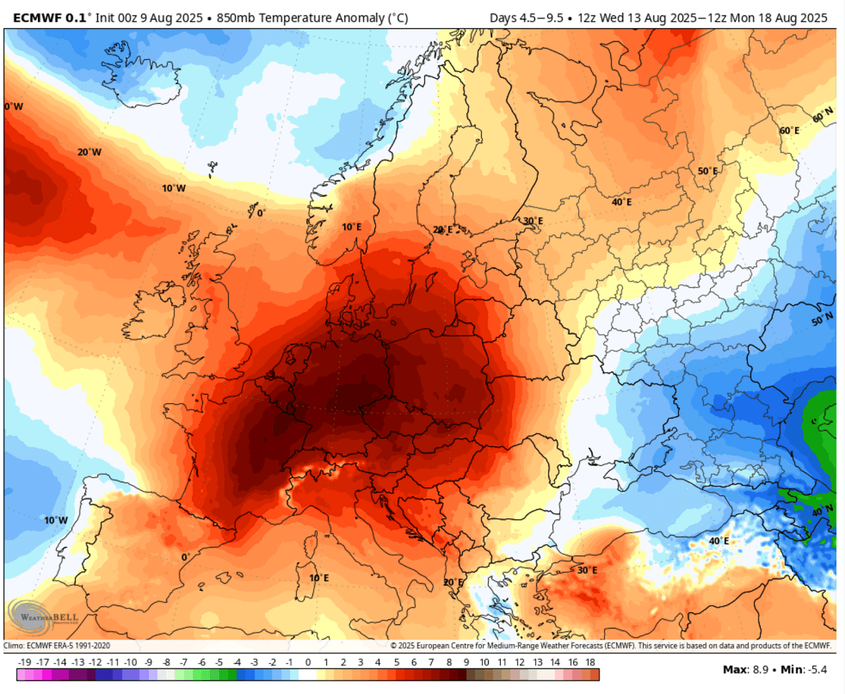
With a heat dome again becoming the dominant feature through mid-month, the effect of subsiding air mass warms and dries up the lower levels as the air mass sinks towards the ground. The extreme heatwave recipe is here.
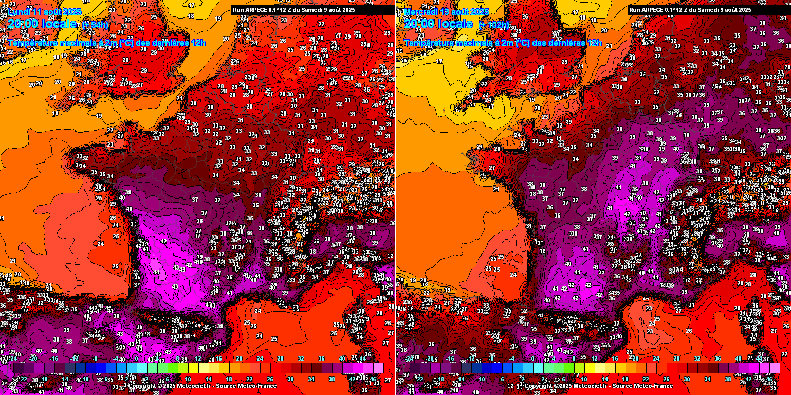
France will reach 40-44 °C in the south and central plains from Sunday through Wednesday, with the upper 30s gradually reaching towards Benelux and western Germany.
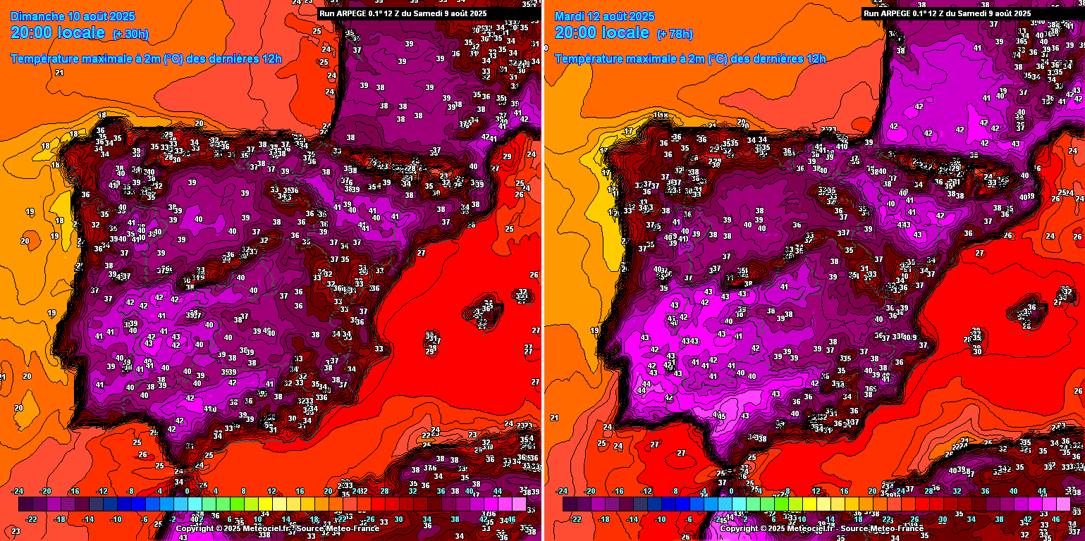
Spain and Portugal will see no real change from the ongoing extreme conditions. Each of the following 7 days will push many regions into the low 40s, with Tuesday likely to bring the week’s highest temperatures.
Typically, the most significant temperatures will be over south-central Portugal and southern and western Spain, with maximum temperatures around 41-44 °C for multiple days.
As the heatwave expands north and east into mid-week, temperatures will also increase over most of Germany. On Tuesday and Wednesday, the western part of the country should experience temperatures in the upper 30s to near 40 °C.
Wednesday will also bring much higher temperatures across central, northern, and southern Germany. The peak afternoon temperatures are forecasted to reach 36-39 °C.
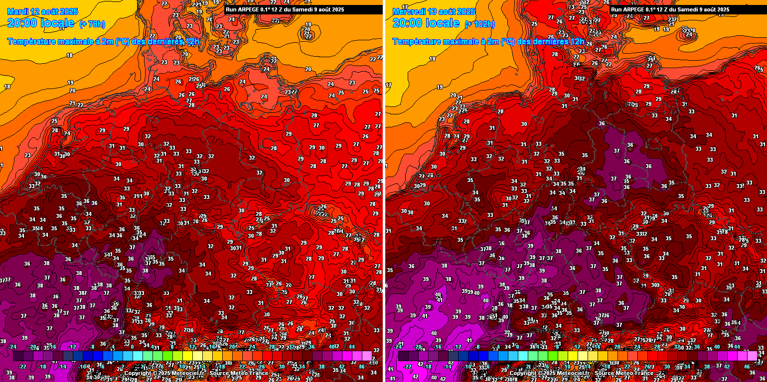
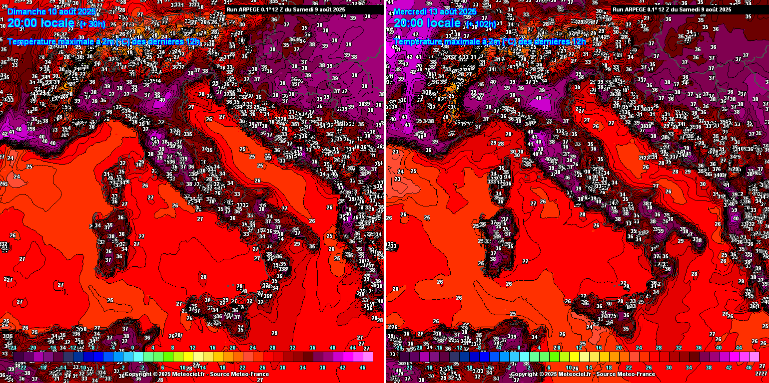
Central Europe, Italy, and the Balkan countries will see the first extreme conditions on Sunday as the eastern edge of the heat dome rises over the Alps.
Due to the favorable pressure patterns over the continent, the downslope dry winds in some areas will allow temperatures to climb extremely high, most likely challenging some heat records across the northern Mediterranean region and Adriatic coast.
North Italian plains and Tuscany will reach 42 °C from Sunday through Wednesday. The heat will be extreme! The highest temperatures continue pushing all days into the upper 30s to low 40s °C over the central and southern Balkans, especially across eastern Croatia, Bosnia, Hungary, and Serbia.
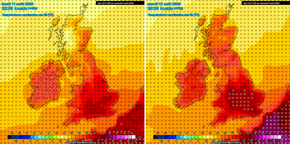
The weather charts for the UK and Ireland have significantly improved since our latest update, meaning temperatures will be much higher. So, Ireland and the UK are now expected to experience an intense heatwave. Temperatures over Ireland and Scotland will push into the mid-20s, while those in southern and central England will move back into the 30s by Monday.
Most weather models agree that Tuesday will be the hottest day. Peak afternoon temperatures will reach 32-34 °C, possibly touching the 35 °C mark in some areas.
Overall, conditions similar to those of the whole week are forecast to extend into the weekend and most likely into the following week. Both global models, ECMWF and GFS, are well-aligned on the mid-term trends, potentially extending the heat dome and historic heatwave for another week.
** With the return of much hotter weather, we advise everyone to be cautious when using an open fire while camping during the holidays. Monitor the local countries that already have alerts on this matter, and some of them are also forbidding the use of fire due to the extreme drought underway. **
Wxcharts, WeatherBell, and Wetterzentrale provided images for use in this article.