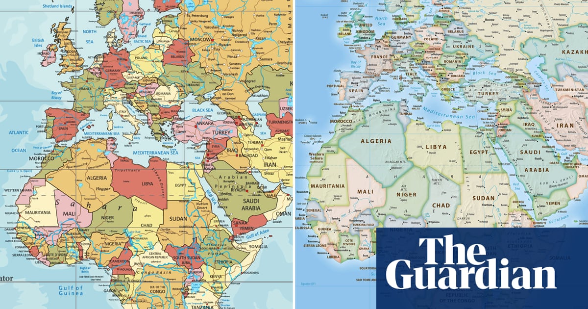
The African Union has backed a campaign to end the use by governments and international organisations of the 16th-century Mercator map of the world in favour of one that more accurately displays Africa’s size.
Created by the cartographer Gerardus Mercator for navigation, the projection distorts continent sizes, enlarging areas near the poles like North America and Greenland while shrinking Africa and South America. “It might seem to be just a map, but in reality, it is not,” the African Union Commission deputy chair, Selma Malika Haddadi, told Reuters, saying the Mercator fostered a false impression that Africa was “marginal”, despite being the world’s second-largest continent by area, with more than 1 billion people. The union has 55 member states.
A 16th-century map of Africa from Mercator’s atlas. Photograph: Royal Geographical Society/Getty Images
Such stereotypes influence media, education and policy, she said.
Gerardus Mercator. Photograph: Archive Photos/Getty Images
Criticism of the Mercator map is not new, but the Correct the Map campaign led by the advocacy groups Africa No Filter and Speak Up Africa has revived the debate, urging organisations to adopt the 2018 Equal Earth projection, which tries to reflect countries’ true sizes.
“The current size of the map of Africa is wrong,” said Moky Makura, the executive director of Africa No Filter. “It’s the world’s longest misinformation and disinformation campaign, and it just simply has to stop.”
Fara Ndiaye, a co-founder of Speak Up Africa, said the Mercator affected Africans’ identity and pride, especially children who might encounter it early in school.
“We’re actively working on promoting a curriculum where the Equal Earth projection will be the main standard across all [African] classrooms,” Ndiaye said, adding she hoped it would also be the one used by global institutions, including Africa-based ones. Haddadi said the AU endorsed the campaign, adding it aligned with its goal of “reclaiming Africa’s rightful place on the global stage” amid growing calls for reparations for colonialism and slavery.
The AU will advocate for wider map adoption and discuss collective actions with member states, Haddadi added.
The Mercator projection is still widely used, including by schools and tech companies. Google Maps switched from Mercator on desktop to a 3D globe view in 2018, though users can still switch back to the Mercator if they prefer.
skip past newsletter promotion
Nesrine Malik and Jason Okundaye deliver your weekly dose of Black life and culture from around the world
Privacy Notice: Newsletters may contain info about charities, online ads, and content funded by outside parties. For more information see our Privacy Policy. We use Google reCaptcha to protect our website and the Google Privacy Policy and Terms of Service apply.
after newsletter promotion
The Equal Earth map advocated by the Correct the Map campaign. Photograph: equal-earth.com
On the mobile app, however, the Mercator projection remains the default.
Correct the Map wants organisations such as the World Bank and the UN to adopt the Equal Earth map. A World Bank spokesperson said it already used the Winkel tripel projection or Equal Earth for static maps and was phasing out Mercator on web maps.
The campaign said it had sent a request to the UN geospatial body, UN-GGIM. A UN spokesperson said that once received it must be reviewed and approved by a committee of experts.
Other regions are backing the AU’s efforts. Dorbrene O’Marde, the vice-chair of the Caribbean Community (Caricom) Reparations Commission, endorsed Equal Earth as a rejection of the Mercator map’s “ideology of power and dominance”.