Sunday, 28 September 2025, 19:03
Spain’s state meteorological agency (Aemet) has updated the weather warning for extreme risk of rainfall to red level in the provinces of Valencia and Castellón from this Sunday evening, 28 September. The new forecasts indicate that heavy downpours of rain could continue until Tuesday morning.
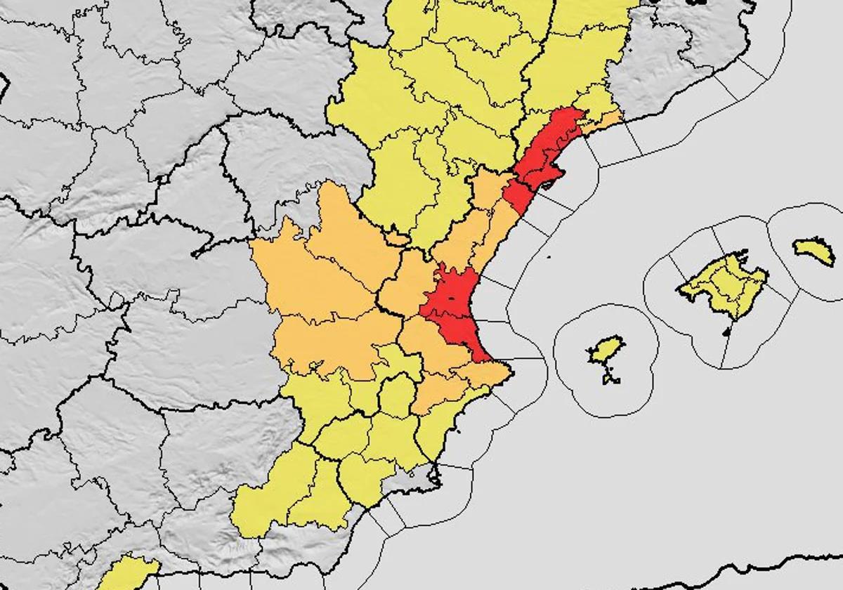
In fact, Aemet has warned of the “extraordinary danger” in the provinces of Tarragona, Castellón and Valencia and forecast that there could be flash flooding and watercourses could break their banks.
According to the latest Aemet forecast, the extreme risk of rain affects areas along the coast of Castellón and Valencia, where the accumulated rainfall in 12 hours could reach 180mm In fact, in some places this figure could be reached in just three or four hours.
The emergency coordination centre of the Generalitat regional government, according to the Aemet forecast, has already decreed a red alert for rain on the north coast of Castellón and the entire coast of Valencia. Inland, it is still amber and in Alicante it is yellow.
In Castellón, the red warning for extreme rain begins this Sunday from 8 pm and will be extended throughout the day on Monday, when the coast of the province of Valencia will be added to the alert – from 4am – which could affect areas hit by the ‘Dana’ of eleven months ago.
At 3.30pm this Sunday the population of Valencia received the ES-Alert message, warning of a red risk of heavy rain for Monday, September 29- Specifically, the message people received on their mobile phones stressed the need to avoid travel and crossing flood-prone areas, in addition to respecting all traffic closures that may occur due to the storm. Likewise, the Generalitat (regional government) urged residents near flood zones to seek higher ground or go to a higher floor, and in all cases to follow the instructions issued by the relevant authorities.
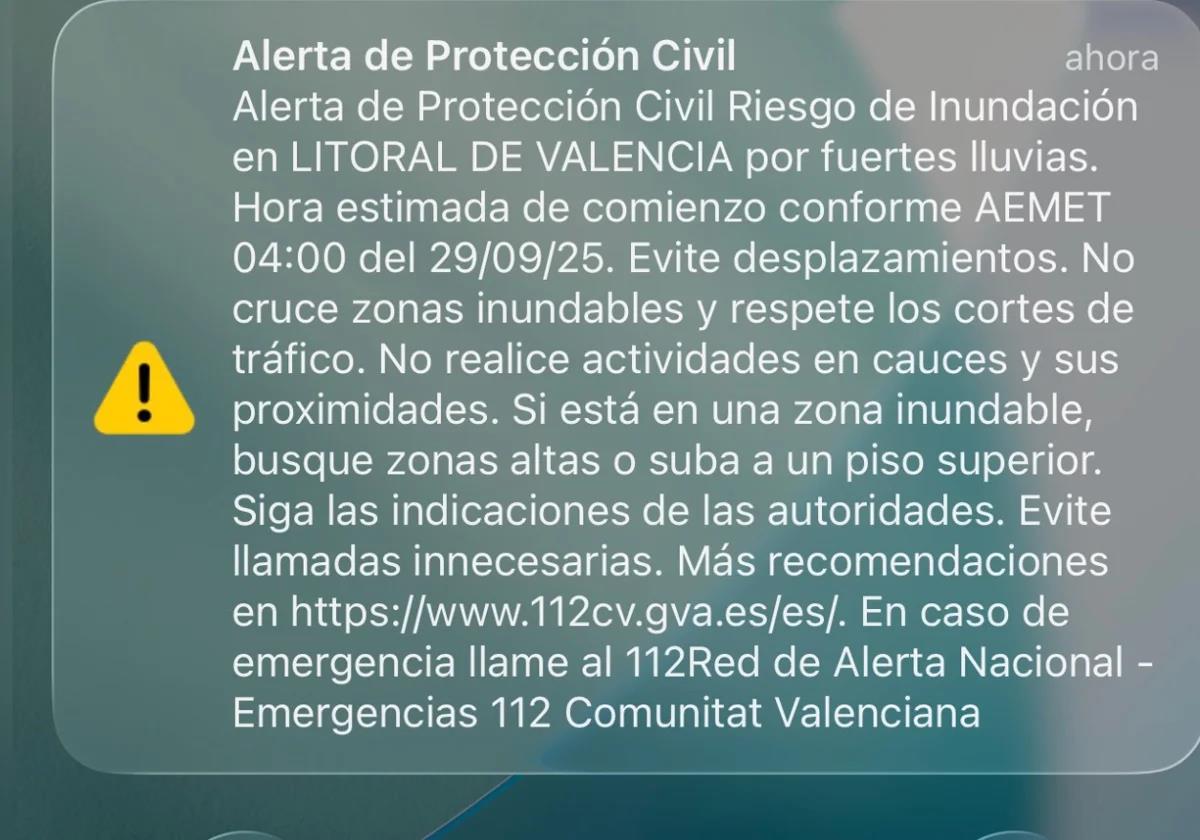
The ES-Alert issued by the civil protection agency.
SUR
The PM of the Spanish government, Pedro Sánchez, has called for «great caution» in the face of the heavy rains expected in the coming hours, especially in the provinces of Tarragona, Castellón and Valencia on Sunday evening and Monday. “Let us follow the instructions of the civil protection agency and the emergency services at all times,” he urged on his X social media account.
Spain’s national roads authority, the Directorate-General of Traffic (DGT), has recommended avoiding driving as far as possible from Sunday afternoon, especially in the provinces of Valencia and Castellón due to the risk of heavy rainfall forecast in the area.
(12:30 h) El Centro de Coordinación de Emergencias de la @generalitat actualiza las alertas por lluvias y tormentas para hoy y mañana:
➡️Para hoy:
🔴nivel rojo por lluvias en el litoral norte de Castellón
🟠nivel naranja por lluvias y tormentas en el interior de Valencia
🟡nivel… pic.twitter.com/Lsujor7wWe— Emergències 112CV (@GVA112) September 28, 2025
In view of the weather forecast, Valencia city council has decreed the suspension of all school activities in the districts affected by the ‘Dana’ and in flood-prone areas. At the same time, Valencia has also suspended the outdoor sports activities of the municipal sports foundation; the city’s parks and gardens and the facilities inside them are closed, as well as the municipal cemeteries, and the CAES del Carmen weather emergency centre has been opened in addition to the CAES in Santa Cruz de Tenerife and Benimaclet.
Meeting of the Generalitat
The regional secretary for emergencies and the Interior, Irene Rodríguez, has announced that the emergencies and security authorities have met in order to coordinate “all the preventive measures that need to be taken in the face of this episode of heavy rain”.
Specifically, she detailed that it involved “all the fire service resources of the Valencia region, the government delegation, the state meteorological agency (Aemet), forest firefighters, roads and health departments, etc.”: “All the services involved in these rain services have been called to this meeting”.
The aim of the meeting is “initially to see what the forecast is and how it will progress over the next few hours”. “To have the most up-to-date information possible and to take preventive decisions to protect the population and self-protection,” she remarked.
Local flash flood risk
In the coming hours the former-hurricane Gabrielle, now a storm, will penetrate the west of the Iberian Peninsula, moving towards the southeast as it rapidly loses intensity. However, the sine of low pressure that will remain over the southern third of the Iberian Peninsula, together with the high pressure to the north, will give rise to a humid flow from the east over the Mediterranean coast which, together with the subtropical humidity at mid-levels and the instability associated with the high trough that accompanies the disturbance, could give rise to very heavy and persistent rain in the southern and eastern third of the Iberian Peninsula over the next few days.
According to Aemet, the downpours may lead to ” local sudden and flash floods” in low-lying areas, streams and wadis, so the potential danger level of this situation is high.
According to the state forecast, Monday 29 and Tuesday 30 September will be the most adverse days of the episode. The greatest intensities and accumulations of rain are expected in the south of the Valencia region, and especially in the province of Valencia, between Monday and the first half of Tuesday, when 250-300mm could be exceeded, with torrential intensities.